NSL – Netzwerk Stadt und Landschaft ETH Zürich
  • Progetti
      • Progetti delle cattedre
        • Prof. Dr. Bryan T. Adey | Gestione delle infrastrutture
        • Prof. Dr. Tom Avermaete | Storia e teoria dell’urbanistica
        • Prof. Dr. Kay W. Axhausen | Pianificazione dei trasporti
        • Prof. Dr. Francesco Corman | Sistemi di trasporto
        • Prof. Teresa Galí-Izard | Chair of Being Alive
        • Prof. Dr. Adrienne Grêt-Regamey | Pianificazione paesaggistica e sistemi urbani
        • Prof. Dr. Eva Heinen | Pianificazione dei trasporti e della mobilità
        • Prof. Dr. David Kaufmann | Sviluppo del territorio e politica urbana
        • Prof. Hubert Klumpner | Architettura e Urbanistica
        • Dr. Anastasios Kouvelas | Ingegneria e controllo del traffico
        • Prof. Dr. Christian Schmid | Sociologia
        • Prof. Milica Topalovic | Architettura e pianificazione territoriale
        • Dr. Jennifer Duyne Barenstein | ETH Wohnforum – ETH CASE
        • NSL-Archiv
      • Ex cattedre
      • Colloqui NSL – Il colloquio NSL è una presentazione semestrale di lavori eccellenti. Il tema viene stabilito di volta in volta dal professore che presenta l’invito.
      • Progetti NSL
          • E-Bike City
          • Future Cities Lab Global
          • Urbane Potentiale und Strategien in metropolitanen Territorien
 – am Beispiel des Metropolitanraums Zürich (NFP65)
          • Large-scale Virtualization and Modeling Lab (LVML)
      • NSL Forum
        • NSL Forum & Cycling Research Board
        • NSL Forum: Pandemie? Mitten im Klimawandel. Was bedeutet das für die räumliche Entwicklung der Schweiz? Ein Dialog.
    Close
  • Insegnamento
    • Insegnamento
        • Bachelor e Master dipartimento ARCH
        • Bachelor e master dipartimento BAUG
        • MSc in Sviluppo territoriale e sistemi infrastrutturali
        • MAS/CAS in Regenerative Materials
        • CAS ETH in Regenerative Systems: dalla sostenibilità alla rigenerazione
        • MAS/CAS Pianificazione del territorio
        • MAS Urban and Territorial Design
        • MAS ETH in edilizia abitativa
        • Doctoral Programme in Landscape and Urban Studies
      • La conoscenza delle forze decisive per lo sviluppo del territorio e la loro interazione, nonché la capacità di sviluppo di strategie risolutive per problematiche territoriali rappresentano i presupposti centrali per lo svolgimento responsabile ed efficace di funzioni di pianificazione al servizio della collettività e di imprese private. Altrettanto importanti sono la formazione, il perfezionamento e l'agggiornamento universitari nel settore della pianificazione territoriale, urbana e del paesaggio. Dal 1965 l'ETH di Zurigo offre corsi di aggiornamento e percorsi di studi post-laurea (NDS, oggi MAS) in questo ambito. I corsi sono gestiti dalla Rete Scientifica Città e Paesaggio (NSL).
    Close
  • Pubblicazioni
    • Cover NL 65Newsletter – NSL riunisce esperti dell’ETH di Zurigo e cura il dialogo con altri ambienti che si occupano o si interessano di questioni relative alla città e al paesaggio.
    • A map describing the different phases of India’s neoliberal highway programme. Source: The author.Pubblicazioni delle cattedre di NSL – Un elenco completo delle pubblicazioni con funzioni di ricerca avanzate è disponibile al seguente link:
      • ETH Zürich Research Collection
    • disP – The Planning Review – La rivista scientifica interdisciplinare tratta temi legati a sviluppo territoriale, urbanistica, pianificazione paesaggistica e ambientale, architettura del paesaggio, economia regionale e ambientale e pianificazione del traffico.
      • Istruzioni per autori / autrici
      • Types of Articles
      • Editore
      • Guida per la stesura di recensioni letterarie
      • Redazione
      • Ultimo numero
      • facebook
    • DELUS Cover Issue 1DELUS – Journal for Landscape and Urban Studies – DELUS è una pubblicazione annuale dell’Istituto di studi urbani e del paesaggio dell’ETH di Zurigo.
    Close
  • Attualità
  • Contatto
      • it
        • de
        • en
        • fr
      • Search

    • Close
      • it
        • de
        • en
        • fr

Using Macroscopic Fundamental Diagrams to Estimate Traffic Heterogeneity

Capacity gained for various sample sizes for the city of Lucerne and four regions in London. Image: Lukas Ambühl, Allister Loder

The macroscopic fundamental diagram provides insights on traffic flow at a macroscopic level. Given its elegance, it has become a popular tool to analyse various traffic-related problems. We show that the MFD can also be used to estimate the level of heterogeneity in a network, which allows city planners the possibility to analyse the efficiency of their road network.

The macroscopic fundamental diagram (MFD) relates the average traffic density to the average flow in an urban network. Under relatively homogeneous conditions, a well-defined MFD exists, where the average traffic flow increases with the average traffic density until a maximum is reached. Afterwards, the flow reduces with increasing traffic density. In other words, the MFD offers an elegant way to model traffic flow macroscopically. It has been shown that the MFD is determined mainly by the urban road structure, traffic control (Geroliminis & Daganzo, 2007), and the level of inhomogeneity in the distribution of traffic (Daganzo, Gayah, & Gonzales, 2011; Gayah & Daganzo, 2011; Knoop, van Lint, & Hoogendoorn, 2015). Even though it was shown that the MFD exists in simulations as well as in the real world, there remains much uncertainty in the estimation of the MFD under real-world traffic conditions and urban dynamics. 

New Re-sampling Methodology

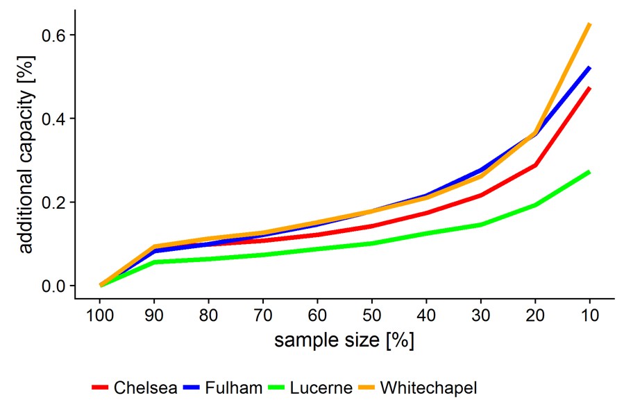
We propose a new re-sampling methodology that allows estimating the level of heterogeneity. Knowing the level of homogeneity allows to evaluate how efficient the road infrastructure is used by vehicles. Generally, the MFD is derived by a length-weighted average of flows and densities across all links in a city. This method, however, might not offer a complete view of traffic conditions. During the morning commute, for example, roads leading into the city are more congested than those leading out. Taking averages of flow and density might provide an estimate on the actual mean performance of the network, but not on the potential performance (i.e. when all links are similarly congested). Therefore, the rationale of our proposed method is therefore to determine the least inhomogeneous sub-samples by first creating many random sub-samples of the network and then estimating an MFD for each. The image shows the capacity gained for various sample sizes for the city of Lucerne and four regions in London. For example, if the entire network behaved like the 10% best links, the additional traffic capacity could increase by 25%. We conclude that the area below such curves is directly related to the heterogeneity of a network and gives city planners the possibility to analyse the efficiency of their road network. 

Lukas Ambühl and Allister Loder are PhD students at the Institute for Transport Planning and Systems since 2015 and 2016, respectively. Both are interested in understanding and modeling congestion at the city level. Lukas focuses on the traffic engineering side, whereas Allister focuses on the transport planning perspective. Co-author: Dr. Monica Menendez. They are funded by ETH Research Grants ETH-04 15-1 and ETH-27 16-1. We especially thank Thomas Karrer and Milena Scherer from the city of Lucerne and Ashley Turner and Andy Emmonds from Transport for London (TfL) for their collaboration.

This text is based on the full article: Ambühl, Lukas; Loder, Allister; Menendez, Monica; Axhausen, Kay W. (2018): Introducing a re-sampling methodology for the estimation of empirical macroscopic fundamental diagrams. Transport Research Record. (in print) 

Other References

Daganzo, C. F.; Gayah, V. V.; Gonzales, E. J. (2011): Macroscopic relations of urban traffic variables: Bifurcations, multivaluedness and instability. Transportation Research Part B: Methodological, 45(1). S.278–288. https://doi.org/10.1016/j.trb.2010.06.006

Gayah, V. V.; Daganzo, C. F. (2011): Clockwise hysteresis loops in the Macroscopic Fundamental Diagram: An effect of network instability. Transportation Research Part B: Methodological, 45(4). S.643–655. https://doi.org/10.1016/j.trb.2010.11.006

Geroliminis, N.; Daganzo, C. F. (2007): Macroscopic modeling of traffic in cities. In: TRB 86th Annual Meeting (S. 07–0413). Retrieved from http://moodle.epfl.ch/file.php/7471/2011_/Macroscopic_FD.pdf

Knoop, V. L.; van Lint, H.; Hoogendoorn, S. P. (2015): Traffic dynamics: Its impact on the Macroscopic Fundamental Diagram. Physica A: Statistical Mechanics and Its Applications, 438. S.236–250. https://doi.org/http://dx.doi.org/10.1016/j.physa.2015.06.016


Share this...
  • Facebook
  • Linkedin
  • Whatsapp
  • Email
Questo contributo è stato pubblicato nella seguente newsletter:

38 | Juni 2018: Big Data in der Forschung / Big Data in Research

  • Connecting Large Scale Transport Models and Mobility Trace Data
  • The New Science of Cities
  • Big Data for Assessing Ecosystem Services
  • To Exploit Big Data for the Management of Infrastructure
  • Using Macroscopic Fundamental Diagrams to Estimate Traffic Heterogeneity
Kurzmeldungen
  • NSL Kolloquium Schmelzende Landschaften: Der Film ist online!
  • Alternative Energien für Fitness- und Wellnessangebote als Beitrag zu einem nachhaltigen urbanen Lebensstil
Publikationen
  • Rift – 7.5 Views on the Jordan Valley. Pamphlet 22
  • Estimations of the Potential and the Impact of Rail Freight in Urban Areas
Aktuell
  • The Disappearance of Robin Hood
  • 1. Schweizer Landschaftskongress | 1er congrès suisse sur le paysage
  • NSL Colloquium: Re-Thinking the 21st Century City
  • Prof. Günther Vogt erhält den Ehrendoktortitel der Universität Liechtenstein
  • Ein Planer mit Herz für die Schweizer Demokratie
  • DAS Verkehrsingenieurwesen

Cattedre

Prof. Dr. Bryan T. Adey
Prof. Dr. Kay W. Axhausen
Prof. Dr. Tom Avermaete
Prof. Maria Conen
Prof. Dr. Francesco Corman
Dr. Jennifer Duyne Barenstein
Prof. Teresa Galí-Izard
Prof. Dr. Adrienne Grêt-Regamey
Prof. Dr. Guillaume Habert
Prof. Dr. Eva Heinen
Prof. Damian Jerjen
Prof. Dr. David Kaufmann
Prof. Hubert Klumpner
Dr. Anastasios Kouvelas
Prof. Freek Persyn
Prof. Dr. Christian Schmid
Prof. Milica Topalovic
Prof. Martina Voser

Contatto

Indirizzo
ETH Zürich
NSL – Netzwerk Stadt und Landschaft
Stefano-Franscini-Platz 5
HIL H 44.2
8093 Zürich

Direzione NSL
Direttore: Prof. Dr. David Kaufmann
Vicedirettrice: Prof. Milica Topalovic

Ufficio di coordinamento NSL
Claudia Gebert
Telefono: +41 (0)44 633 36 33


Iscriviti alla newsletter della NSL

Redazione disP

Caporedattrice
Dr. sc. techn. Martina Koll-Schretzenmayr, pianificatrice territoriale ETH/NDS,
Telefono +41 (0)44 633 29 47

Indirizzo
ETH Zürich
Redaktion disP
NSL – Netzwerk Stadt und Landschaft
Stefano-Franscini-Platz 5
HIL H 33.3
8093 Zürich
Fax +41 (0)44 633 12 15
E-Mail

Archivio NSL (gta)

Archivio storico e di ricerca per l’architettura
del paesaggio e la pianificazione ambientale svizzere

Richieste di consultazione

Indirizzo
ETH Zürich
NSL Archive (gta)
Stefano-Franscini-Platz 5
HIL C 65.2
CH-8093 Zurich


Protezione dei dati