NSL – Netzwerk Stadt und Landschaft ETH Zürich
  • Progetti
      • Progetti delle cattedre
        • Prof. Dr. Bryan T. Adey | Gestione delle infrastrutture
        • Prof. Dr. Tom Avermaete | Storia e teoria dell’urbanistica
        • Prof. Dr. Kay W. Axhausen | Pianificazione dei trasporti
        • Prof. Dr. Francesco Corman | Sistemi di trasporto
        • Prof. Teresa Galí-Izard | Chair of Being Alive
        • Prof. Dr. Adrienne Grêt-Regamey | Pianificazione paesaggistica e sistemi urbani
        • Prof. Dr. Eva Heinen | Pianificazione dei trasporti e della mobilità
        • Prof. Dr. David Kaufmann | Sviluppo del territorio e politica urbana
        • Prof. Hubert Klumpner | Architettura e Urbanistica
        • Dr. Anastasios Kouvelas | Ingegneria e controllo del traffico
        • Prof. Dr. Christian Schmid | Sociologia
        • Prof. Milica Topalovic | Architettura e pianificazione territoriale
        • Dr. Jennifer Duyne Barenstein | ETH Wohnforum – ETH CASE
        • NSL-Archiv
      • Ex cattedre
      • Colloqui NSL – Il colloquio NSL è una presentazione semestrale di lavori eccellenti. Il tema viene stabilito di volta in volta dal professore che presenta l’invito.
      • Progetti NSL
          • E-Bike City
          • Future Cities Lab Global
          • Urbane Potentiale und Strategien in metropolitanen Territorien
 – am Beispiel des Metropolitanraums Zürich (NFP65)
          • Large-scale Virtualization and Modeling Lab (LVML)
      • NSL Forum
        • NSL Forum & Cycling Research Board
        • NSL Forum: Pandemie? Mitten im Klimawandel. Was bedeutet das für die räumliche Entwicklung der Schweiz? Ein Dialog.
    Close
  • Insegnamento
    • Insegnamento
        • Bachelor e Master dipartimento ARCH
        • Bachelor e master dipartimento BAUG
        • MSc in Sviluppo territoriale e sistemi infrastrutturali
        • MAS/CAS in Regenerative Materials
        • CAS ETH in Regenerative Systems: dalla sostenibilità alla rigenerazione
        • MAS/CAS Pianificazione del territorio
        • MAS Urban and Territorial Design
        • MAS ETH in edilizia abitativa
        • Doctoral Programme in Landscape and Urban Studies
      • La conoscenza delle forze decisive per lo sviluppo del territorio e la loro interazione, nonché la capacità di sviluppo di strategie risolutive per problematiche territoriali rappresentano i presupposti centrali per lo svolgimento responsabile ed efficace di funzioni di pianificazione al servizio della collettività e di imprese private. Altrettanto importanti sono la formazione, il perfezionamento e l'agggiornamento universitari nel settore della pianificazione territoriale, urbana e del paesaggio. Dal 1965 l'ETH di Zurigo offre corsi di aggiornamento e percorsi di studi post-laurea (NDS, oggi MAS) in questo ambito. I corsi sono gestiti dalla Rete Scientifica Città e Paesaggio (NSL).
    Close
  • Pubblicazioni
    • Cover NL 65Newsletter – NSL riunisce esperti dell’ETH di Zurigo e cura il dialogo con altri ambienti che si occupano o si interessano di questioni relative alla città e al paesaggio.
    • A map describing the different phases of India’s neoliberal highway programme. Source: The author.Pubblicazioni delle cattedre di NSL – Un elenco completo delle pubblicazioni con funzioni di ricerca avanzate è disponibile al seguente link:
      • ETH Zürich Research Collection
    • disP – The Planning Review – La rivista scientifica interdisciplinare tratta temi legati a sviluppo territoriale, urbanistica, pianificazione paesaggistica e ambientale, architettura del paesaggio, economia regionale e ambientale e pianificazione del traffico.
      • Istruzioni per autori / autrici
      • Types of Articles
      • Editore
      • Guida per la stesura di recensioni letterarie
      • Redazione
      • Ultimo numero
      • facebook
    • DELUS Cover Issue 1DELUS – Journal for Landscape and Urban Studies – DELUS è una pubblicazione annuale dell’Istituto di studi urbani e del paesaggio dell’ETH di Zurigo.
    Close
  • Attualità
  • Contatto
      • it
        • de
        • en
        • fr
      • Search

    • Close
      • it
        • de
        • en
        • fr

Settlement Relationships and their Morphological Homogeneity Across Time and Scale

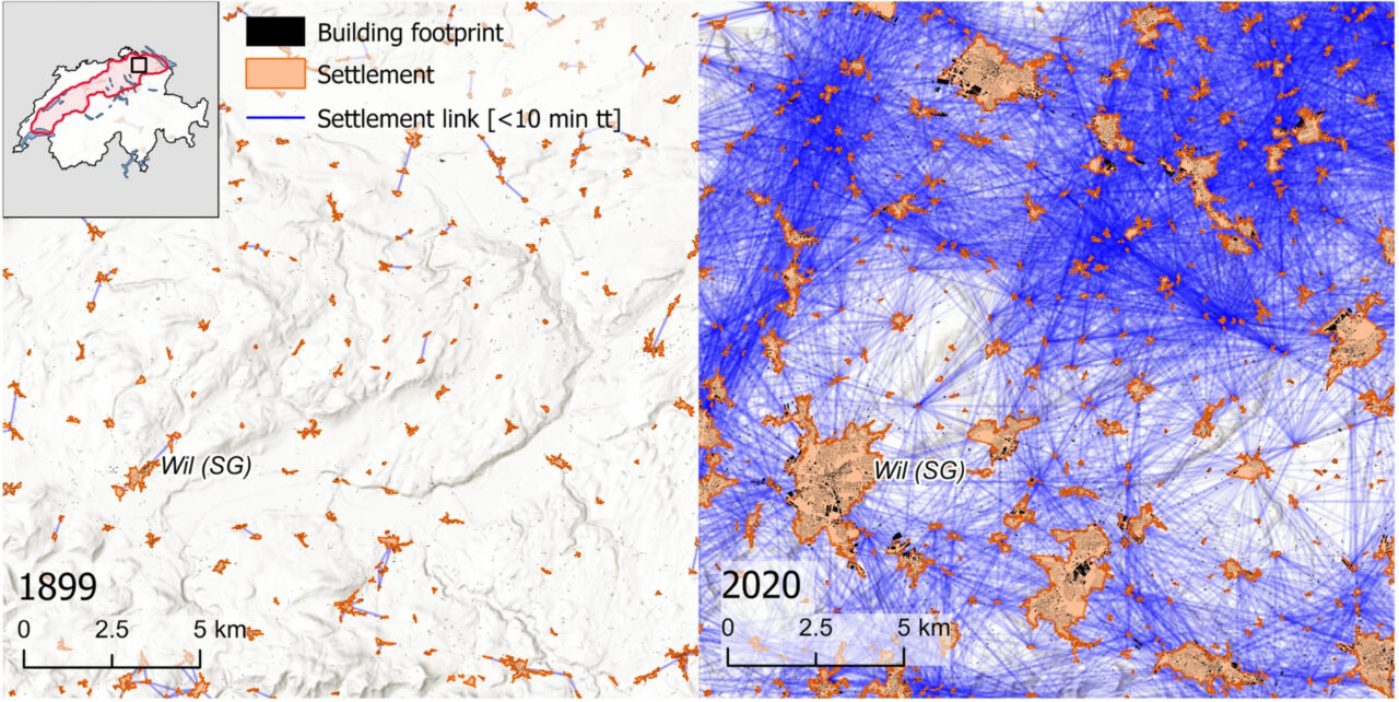
Example of the settlement network evolution between 1899 and 2020. This depiction shows the same area in the north-east of the study area, between Winterthur (ZH) and St. Gallen (SG), at two different time steps. The settlement links represent pairs of settlements that are reachable within 10 min of travel time (tt). The size of the settlements has changed over time, as they have sprawled and merged with one another. Hill-shade map source: ESRI, CGIAR, and USGS

Yves M. Räth, Adrienne Grêt-Regamey, Chenjing Jiao, Sidi Wu, Maarten J. van Strien
2023
Full text

Homogeneous settlement morphologies negatively impact urban vibrancy, the environment, and emotions. Mainly resulting from the separation of functions such as work and living, homogeneous settlements have often been found around large cities.

However, it remains unknown whether this phenomenon occurs in settlements of any size and persisted over time. In this study, we investigated the relationship between the internal structures of settlements and their location within a settlement network at a large spatial scale and a fine resolution, over seven time steps covering 120 years of settlement development. Using building footprints and road geometries from historical maps of the Swiss Plateau in combination with historical travel speeds, we analyzed networks at both the local- (building networks) and the regional-scale (settlement networks). Our findings show that particularly small settlements located near larger settlements exhibit a high degree of morphological homogeneity, and that this pattern persisted since the early twentieth century despite strong changes in mobility. These results suggest that the position of a settlement within a settlement network can have an impact on its morphological homogeneity, which in turn can have consequences for the functionality and livability of the settlement and provides useful insight to the development of settlements.
Leggi anche

Beispiel für die Zeitreihe des Verkehrsvolumens auf ländlichen Strassen (rote Linien) in der Region um die Stadt Peking in China. Das Jahr für jeden Zeitschritt steht unterhalb der Abbildung. Die Breite des Strassenabschnitts ist proportional zum Verkehrsvolumen auf der Strasse. Die Ausdehnung des Stadtgebiets ist in Dunkelrot dargestellt. Es ist deutlich zu erkennen, dass der Strassenverkehr im ländlichen Gebiet dieser Region zwischen 1975 und 2015 stark zugenommen hat. © ETH Zürich

Globale Modellierung des ländlichen Strassenverkehrs ausserhalb der Städte
» Articoli newsletter

×
Share this...
  • Facebook
  • Linkedin
  • Whatsapp
  • Email
Questo contributo è stato pubblicato nella seguente newsletter:

60 | Dezember 2023: Resiliente Urbane Systeme / Resilient Urban Systems

  • Wie verändert sich das Verkehrsgleichgewicht durch Home office?
  • City of Codes
  • Adaptive Urban Planning for an Uncertain Future: Infrastructure Interventions for the Technological Shift in Transportation
  • Antifragile Urban Mobility: Traffic Control Beyond Resilience
  • Zwischen Wolkenkratzern und Zustimmung? Über Akzeptanz für urbane Verdichtung aus raumplanerischer Perspektive
  • Escape Determinism – Unlocking Desirable Urban Development Pathways
  • Verfechter des öffentlichen Raums
Kurzmeldungen
  • NSL Colloquium Planetary Urbanisation: Video now Online!
  • Prof. Maria Conen und Prof. Dr. Elli Mosayebi erneuern das Direktorium des ETH Wohnforum
  • Community-led Landscape Restoration 2024: Call for Applications
  • Martina Voser zur ordentlichen Professorin für Landschaftsarchitektur ernannt
  • Prof. Dr. Eva Heinen zur ordentlichen Professorin für Verkehrs-​ und Mobilitätsplanung ernannt
Publikationen
  • Vocabularies for an Urbanising Planet: Theory Building through Comparison NOW OPEN ACCESS DOWNLOAD
  • Extended Urbanisation. Tracing Planetary Struggles NOW OPEN ACCESS DOWNLOAD!
  • Settlement Relationships and their Morphological Homogeneity Across Time and Scale
  • Listening In: Conversations on Architectures, Cities and Landscapes, 1700-1900 – Programme and Abstracts
  • disP 59/2, June 2023
Weiterbildung / Studiengänge
  • EPFL ETH MAS Urban and Territorial Design
  • MAS ETH in Housing
Aktuell
  • LUS Doctoral Crits
  • Planetary Urbanisation – Aufruf zur Tat | Agrifutures Zürich – Agrarökologisches Gestalten
  • Reflective Practitioners

Cattedre

Prof. Dr. Bryan T. Adey
Prof. Dr. Kay W. Axhausen
Prof. Dr. Tom Avermaete
Prof. Maria Conen
Prof. Dr. Francesco Corman
Dr. Jennifer Duyne Barenstein
Prof. Teresa Galí-Izard
Prof. Dr. Adrienne Grêt-Regamey
Prof. Dr. Guillaume Habert
Prof. Dr. Eva Heinen
Prof. Damian Jerjen
Prof. Dr. David Kaufmann
Prof. Hubert Klumpner
Dr. Anastasios Kouvelas
Prof. Freek Persyn
Prof. Dr. Christian Schmid
Prof. Milica Topalovic
Prof. Martina Voser

Contatto

Indirizzo
ETH Zürich
NSL – Netzwerk Stadt und Landschaft
Stefano-Franscini-Platz 5
HIL H 44.2
8093 Zürich

Direzione NSL
Direttore: Prof. Dr. David Kaufmann
Vicedirettrice: Prof. Milica Topalovic

Ufficio di coordinamento NSL
Claudia Gebert
Telefono: +41 (0)44 633 36 33


Iscriviti alla newsletter della NSL

Redazione disP

Caporedattrice
Dr. sc. techn. Martina Koll-Schretzenmayr, pianificatrice territoriale ETH/NDS,
Telefono +41 (0)44 633 29 47

Indirizzo
ETH Zürich
Redaktion disP
NSL – Netzwerk Stadt und Landschaft
Stefano-Franscini-Platz 5
HIL H 33.3
8093 Zürich
Fax +41 (0)44 633 12 15
E-Mail

Archivio NSL (gta)

Archivio storico e di ricerca per l’architettura
del paesaggio e la pianificazione ambientale svizzere

Richieste di consultazione

Indirizzo
ETH Zürich
NSL Archive (gta)
Stefano-Franscini-Platz 5
HIL C 65.2
CH-8093 Zurich


Protezione dei dati