NSL – Netzwerk Stadt und Landschaft ETH Zürich
  • Projects
      • Projects of the Chairs
        • Prof. Dr. Bryan T. Adey | Infrastructure Management
        • Prof. Dr. Tom Avermaete | History and Theory of Urban Design
        • Prof. Dr. Kay W. Axhausen | Traffic and Transport Planning
        • Prof. Dr. Francesco Corman | Transport Systems
        • Prof. Teresa Galí-Izard | Chair of Being Alive
        • Prof. Dr. Adrienne Grêt-Regamey | Planning of Landscape and Urban Systems (PLUS)
        • Prof. Dr. Eva Heinen | Transportation and Mobility Planning
        • Prof. Dr. David Kaufmann | Spatial Development and Urban Policy
        • Prof. Hubert Klumpner | Architecture and Urban Design
        • Dr. Anastasios Kouvelas | Traffic Engineering and Control
        • Prof. Dr. Christian Schmid | Sociology
        • Prof. Milica Topalovic | Architecture and Territorial Planning
        • Dr. Jennifer Duyne Barenstein | ETH Wohnforum – ETH CASE
        • NSL-Archiv
      • Former Chairs
      • NSL Colloquia – The NSL Colloquia are a bi-annual presentation of exceptional work under a rotating theme determined by the inviting professor.
      • NSL Projects
          • E-Bike City
          • Future Cities Lab Global
          • Urban Potential and Strategies in Metropolitan Territories
 – The Zurich Metropolitan Region as an Example (NFP65)
          • Large-scale Virtualization and Modeling Lab (LVML)
      • NSL Forum
        • NSL Forum & Cycling Research Board
        • NSL Forum: Pandemie? Mitten im Klimawandel. Was bedeutet das für die räumliche Entwicklung der Schweiz? Ein Dialog.
    Close
  • Teaching
    • Teaching
      • Bachelor and Master Degree Programmes, Department ARCH
      • Bachelor and Master Degree Programmes, Department BAUG
      • MSc in Spatial Development and Infrastructure Systems
      • MAS/CAS in Regenerative Materials
      • CAS in Regenerative Systems: Sustainability to Regeneration
      • MAS/CAS Spatial Development
      • MAS Urban and Territorial Design
      • MAS in Housing
      • Doctoral Programme in Landscape and Urban Studies
      • The teaching component of the NSL seeks to impart the knowledge and skills needed to develop the standard strengths of spatial planning and their interaction as well as the ability to develop strategies for the solution of spatial problems. These are central prerequisites for a responsible and successful exercise of planning functions in the service of the public commonwealth and of private companies. Especially important in fufilling these prerequisites is the quality of university-level education: graduate and post-graduate work as well as professional development in spatial, urban and landscape planning. The ETH Zurich has offered programmes such as continuing education courses and post-graduate programmes (NDS, now MAS) since 1965. The NSL (Network City and Landscape) is responsible for these courses and programmes.
    Close
  • Publications
    • Cover NL 65NSL Newsletter – The NSL brings the experts at ETH Zurich together and also maintains a dialogue with other groups that deal with or are interested in issues relating to cities and landscapes.
    • A map describing the different phases of India’s neoliberal highway programme. Source: The author.Publications of NSL Chairs – A complete list of publications can be reached via the following link, which also includes advanced search capabilities:
      • ETH Zürich Research Collection
    • disP – The Planning Review – The interdisciplinary scientific journal covers the topics of spatial development, urban planning, landscape and environmental planning, landscape architecture, traffic planning, and regional and environmental economics, as well as special issues on specific themes.
      • Instructions for Authors
      • Types of Articles
      • Publisher
      • Book Review Guidelines
      • Editorial Staff
      • Latest Issue
      • facebook
    • DELUS Cover Issue 1DELUS – Journal for Landscape and Urban Studies – DELUS is an annual publication by the Institute of Landscape and Urban Studies at ETH Zürich.
    Close
  • News
  • Contact
      • en
        • de
        • fr
        • it
      • Search

    • Close
      • en
        • de
        • fr
        • it

Advancing Tools and Methods for Mobility and Transportation Planning | Module VIII

The flow of people and goods within and through city areas is a fundamental dimension of contemporary urban design, planning and management. Understanding, modelling and simulating such flows in a high-density city such as Singapore was at the core of our research.

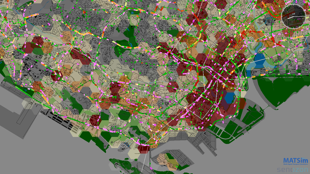
To this end, we implemented and continue to improve a full-scale implementation of the agent-based transport simulation software MATSim for the case of Singapore. We not only enhanced the performance and functionality of this open-source simulation software, but also developed new approaches to improve the use of public transport smart card data to model the spatial dynamics of work activities.

To make MATSim more accessible for practitioners, we developed a new decision support system for transport planning. At the heart of the system is a spatial database that integrates the various data sources required for modelling and manages the input and output of the transport simulation. Various visualization tools connecting to that database help both researchers and planners to better analyse and communicate their findings and plans to different stakeholders.

The availability of public transport smart card data also opened a new strand of research. First, we applied such data to better understand the impact of different bus types and occupancy levels on the time it takes for people to get on and off vehicles. Next, we described the travel time between stops as a function of various attributes of the road network and the built environment. By integrating such models and travel demand derived from smart card data into the simulation tool MATSim, we can turn Big Data into Smart Data, which allows us to predict the impact of redesigning existing or new public transport lines with regard to service reliability and crowdedness.

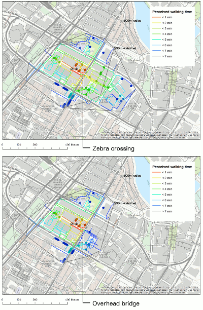
In collaboration with the Urban Redevelopment Authority, we also engaged in a research project to study pedestrian behaviour and quantify the walkability of Singapore’s city centre. With meticulous effort we mapped various characteristics of the built environment that impact the walking quality, such as availability of activated frontages, width of the walkway or cover from sun and rain. The research clearly demonstrated that such urban design qualities not only impact pedestrian’s satisfaction but also their route choice behaviour. To make those findings applicable in planning practice, we also developed a GIS tool that allows the evaluation of the impact of new pedestrian infrastructure and planning policies.

If you are interested in learning more about these three research projects, please refer to the movies:

MATSim Singapore
Big Data MATSim
Embracing Walkability

Researchers for module VIII are Prof. Dr. Kay W. Axhausen, Dr. Alexander Erath, Artem Chakirov, Pieter J. Fourie, Sergio Ordonez, Lijun Sun, Teresa Tan, Michael van Eggermond, Atizaz Ali, and Basil Vitins.
 

NL27: Advancing Tools and Methods for Mobility and Transportation Planning | Module VIII
Case study to evaluate the impact of replacing a pedestrian overhead bridge with a conventional zebra crossing. The walkability tool allows computing and comparing the walksheds for the different planning scenarios.
Share this...
  • Facebook
  • Linkedin
  • Whatsapp
  • Email
This article has been published in the following newsletter edition:

27 | September 2015: Abschlussbericht Future Cities Laboratory FCL

  • ETH’s Architecture and Urbanization Outpost in Singapore: An Interdisciplinary Culture of Collaboration
  • Diverse Neighbourhoods & Airport Regions | Module IV
  • Planetary Urbanization in a Comparative Perspective | Module V
  • Territorial Organization | Module VI
  • Landscape Ecology | Module VII
  • Advancing Tools and Methods for Mobility and Transportation Planning | Module VIII
  • Prof. Dr. Adrienne Grêt-Regamey ist neue NSL-Leiterin
Kurzmeldungen
  • The Hinterland of Contemporary Cities
  • Alternative Building Materials
  • Plans and Politics
Publikationen
  • Brachlandschaften / Wastelands
  • Habitat Marocain Documents: Dynamics Between Formal and Informal Housing
  • radikal normal. Positionen zur Architektur der Stadt
  • Generische Beschreibung von Eisenbahnbetriebsprozessen
  • Theoretikerinnen des Städtebaus. Texte und Projekte für die Stadt
  • System dynamics of urban traffic based on its parking-related-states
  • Gesamtwirtschaftliche Effekte des öffentlichen Verkehrs mit besonderer Berücksichtigung der Verdichtungs- und Agglomerationseffekte
  • The Renaissance of Nakta Mountain

Chairs

Prof. Dr. Bryan T. Adey
Prof. Dr. Kay W. Axhausen
Prof. Dr. Tom Avermaete
Prof. Maria Conen
Prof. Dr. Francesco Corman
Dr. Jennifer Duyne Barenstein
Prof. Teresa Galí-Izard
Prof. Dr. Adrienne Grêt-Regamey
Prof. Dr. Guillaume Habert
Prof. Dr. Eva Heinen
Prof. Damian Jerjen
Prof. Dr. David Kaufmann
Prof. Hubert Klumpner
Dr. Anastasios Kouvelas
Prof. Freek Persyn
Prof. Dr. Christian Schmid
Prof. Milica Topalovic
Prof. Martina Voser

Contact

Address
ETH Zürich
NSL – Netzwerk Stadt und Landschaft
Stefano-Franscini-Platz 5
HIL H 44.2
8093 Zürich

NSL Director
Director: Prof. Dr. David Kaufmann
Deputy Director: Prof. Milica Topalovic

NSL Coordination
Claudia Gebert
Telephone: +41 (0)44 633 36 33


Register for the NSL Newsletter

disP Publication Office

Editor-in-Chief
Dr. sc. techn. Martina Koll-Schretzenmayr, Spatial planner ETH/NDS,
Telephone +41 (0)44 633 29 47

Mailing address
ETH Zürich
Redaktion disP
NSL – Netzwerk Stadt und Landschaft
Stefano-Franscini-Platz 5
HIL H 33.3
8093 Zürich
Fax +41 (0)44 633 12 15
E-Mail


NSL Archive (gta)

Research and Bequest Archive for
Swiss Landscape Architecture and Spatial Planning

Consultation Requests

Mailing address
ETH Zürich
NSL Archive (gta)
Stefano-Franscini-Platz 5
HIL C 65.2
CH-8093 Zurich


Privacy Policy