Scenario planning is increasingly used in urban planning in recognition of the uncertain and complex interactions between the built and the natural environment. Scenario planning develops alternative stories about the future, as combinations of important drivers of change, qualitatively. The use of computational models can inform the development of future scenarios when a large number of factors and scenarios exist.
Qualitative scenario storylines are usually represented through a 2×2 scenario matrix diagram, where four scenarios are proposed as the four combinations of «low» and «high” values of two drivers, X and Y, assigned in each axis.
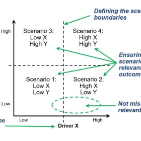
The definition of future scenarios through such a diagram brings some challenges, including:
- How do we know that the drivers X and Y, among all economic, environmental, social, and technological factors, are the most important ones for the scenario generation?
- How do we know that the identified four scenarios produce different outcomes and have relevant implications for planning?
- How can we define sensible boundaries between scenarios beyond the categorical «low» and «high»?
- How can we ensure that we are not missing out on some relevant scenarios that do not fit one of the quadrants perfectly?
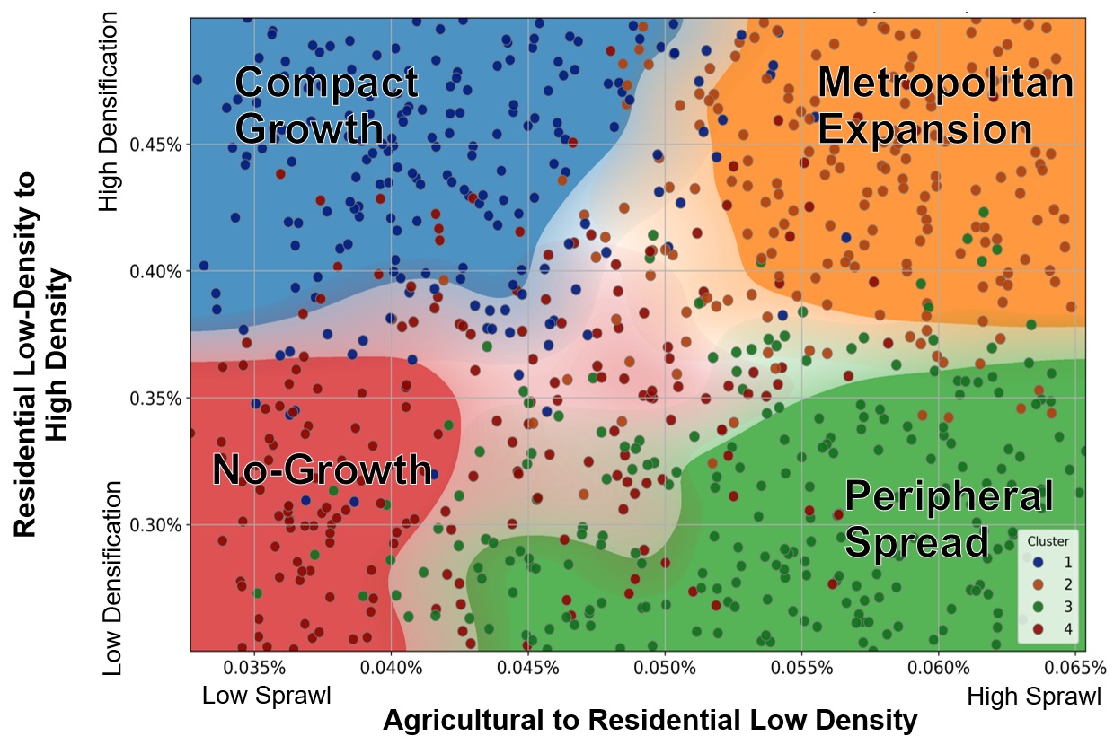
To tackle such challenges, the module Adaptive Mobility, Infrastructure and Land Use, at the Future Cities Laboratory Global, is developing a model-based approach to map future scenarios, quantitatively, using simulations of future land use change. The model-based approach allows the integration of participatory processes, spatial development simulation models, spatial similarity analysis, and clustering techniques to define scenario boundaries that reflect relevant spatial patterns. We use this method to simulate spatial development in the Canton of Zurich for 2050 using a cellular automata Land Use Cover Change (LUCC) model. By varying LUCC transition rates and the influence of different LUCC drivers, we simulated an ensemble of hundreds of potential futures. Using sensitivity analysis, we identified the degree of densification and the degree of sprawl as the main factors of change. Four distinct scenarios, and their respective boundaries, were identified through clustering techniques: «Compact Growth», «Metropolitan Expansion», «Peripheral Spread», and «No Growth».
This quantitative approach proposes a data-driven foundation that can help the construction of scenario narratives by ensuring that the generated scenarios are relevant for planning and spatially different.
 Orlando Roman is a doctoral researcher at the Singapore-ETH Centre and the Infrastructure Management Group of the Institute of Construction and Infrastructure Management, ETH Zürich.
Prof. Dr. Bryan T. Adey is the Head of the Infrastructure Management Group.
Find out more