NSL – Netzwerk Stadt und Landschaft ETH Zürich
  • Progetti
      • Progetti delle cattedre
        • Prof. Dr. Bryan T. Adey | Gestione delle infrastrutture
        • Prof. Dr. Tom Avermaete | Storia e teoria dell’urbanistica
        • Prof. Dr. Kay W. Axhausen | Pianificazione dei trasporti
        • Prof. Dr. Francesco Corman | Sistemi di trasporto
        • Prof. Teresa Galí-Izard | Chair of Being Alive
        • Prof. Dr. Adrienne Grêt-Regamey | Pianificazione paesaggistica e sistemi urbani
        • Prof. Dr. Eva Heinen | Pianificazione dei trasporti e della mobilità
        • Prof. Dr. David Kaufmann | Sviluppo del territorio e politica urbana
        • Prof. Hubert Klumpner | Architettura e Urbanistica
        • Dr. Anastasios Kouvelas | Ingegneria e controllo del traffico
        • Prof. Dr. Christian Schmid | Sociologia
        • Prof. Milica Topalovic | Architettura e pianificazione territoriale
        • Dr. Jennifer Duyne Barenstein | ETH Wohnforum – ETH CASE
        • NSL-Archiv
      • Ex cattedre
      • Colloqui NSL – Il colloquio NSL è una presentazione semestrale di lavori eccellenti. Il tema viene stabilito di volta in volta dal professore che presenta l’invito.
      • Progetti NSL
          • E-Bike City
          • Future Cities Lab Global
          • Urbane Potentiale und Strategien in metropolitanen Territorien
 – am Beispiel des Metropolitanraums Zürich (NFP65)
          • Large-scale Virtualization and Modeling Lab (LVML)
      • NSL Forum
        • NSL Forum & Cycling Research Board
        • NSL Forum: Pandemie? Mitten im Klimawandel. Was bedeutet das für die räumliche Entwicklung der Schweiz? Ein Dialog.
    Close
  • Insegnamento
    • Insegnamento
        • Bachelor e Master dipartimento ARCH
        • Bachelor e master dipartimento BAUG
        • MSc in Sviluppo territoriale e sistemi infrastrutturali
        • MAS/CAS in Regenerative Materials
        • CAS ETH in Regenerative Systems: dalla sostenibilità alla rigenerazione
        • MAS/CAS Pianificazione del territorio
        • MAS Urban and Territorial Design
        • MAS ETH in edilizia abitativa
        • Doctoral Programme in Landscape and Urban Studies
      • La conoscenza delle forze decisive per lo sviluppo del territorio e la loro interazione, nonché la capacità di sviluppo di strategie risolutive per problematiche territoriali rappresentano i presupposti centrali per lo svolgimento responsabile ed efficace di funzioni di pianificazione al servizio della collettività e di imprese private. Altrettanto importanti sono la formazione, il perfezionamento e l'agggiornamento universitari nel settore della pianificazione territoriale, urbana e del paesaggio. Dal 1965 l'ETH di Zurigo offre corsi di aggiornamento e percorsi di studi post-laurea (NDS, oggi MAS) in questo ambito. I corsi sono gestiti dalla Rete Scientifica Città e Paesaggio (NSL).
    Close
  • Pubblicazioni
    • Cover NL 65Newsletter – NSL riunisce esperti dell’ETH di Zurigo e cura il dialogo con altri ambienti che si occupano o si interessano di questioni relative alla città e al paesaggio.
    • A map describing the different phases of India’s neoliberal highway programme. Source: The author.Pubblicazioni delle cattedre di NSL – Un elenco completo delle pubblicazioni con funzioni di ricerca avanzate è disponibile al seguente link:
      • ETH Zürich Research Collection
    • disP – The Planning Review – La rivista scientifica interdisciplinare tratta temi legati a sviluppo territoriale, urbanistica, pianificazione paesaggistica e ambientale, architettura del paesaggio, economia regionale e ambientale e pianificazione del traffico.
      • Istruzioni per autori / autrici
      • Types of Articles
      • Editore
      • Guida per la stesura di recensioni letterarie
      • Redazione
      • Ultimo numero
      • facebook
    • DELUS Cover Issue 1DELUS – Journal for Landscape and Urban Studies – DELUS è una pubblicazione annuale dell’Istituto di studi urbani e del paesaggio dell’ETH di Zurigo.
    Close
  • Attualità
  • Contatto
      • it
        • de
        • en
        • fr
      • Search

    • Close
      • it
        • de
        • en
        • fr

Quantifying long-term evolution of intra-urban spatial interactions

Cities, as the core of modern society, are playing increasingly important roles through global urbanisation, providing people with housing, transportation, communication, and functional institutions for various social activities. Enabled by the transportation infrastructure layer, diverse social interactions among various entities shape a city’s interaction layers, creating social economic outputs, which further spur the growth of the cities themselves.

However, understanding the long-term impact that changes in a city’s transportation infrastructure have on its spatial interactions remains a challenge, as the real impact may not be revealed in static or aggregated mobility measures such as traffic flow, which are remarkably robust to perturbations. More generally, the lack of longitudinal and cross-sectional data demonstrating the evolution of spatial interactions at a meaningful urban scale further hinders evaluation of the sensitivity of movement indicators, limiting our capacity to understand the evolution of urban mobility in depth.

Lijun Sun and team from the Future Cities Laboratory of the Singapore-ETH Centre investigated ways to detect the change of urban structure using emerging big data. Using large-scale individual-based transit data over three years, the team quantified the impact of the completion of a metro line extension – the Circle Line (CCL) in Singapore on the urban structural evolution of Singapore.

In the paper Quantifying Long-term Evolution of Intra-urban Spatial Interactions published in the Journal of The Royal Society Interface, the team reported that, despite Singapore being known to be a dynamic and fast-changing city, human mobility displays robust statistical patterns invariance before and after the public transit infrastructure was completed.

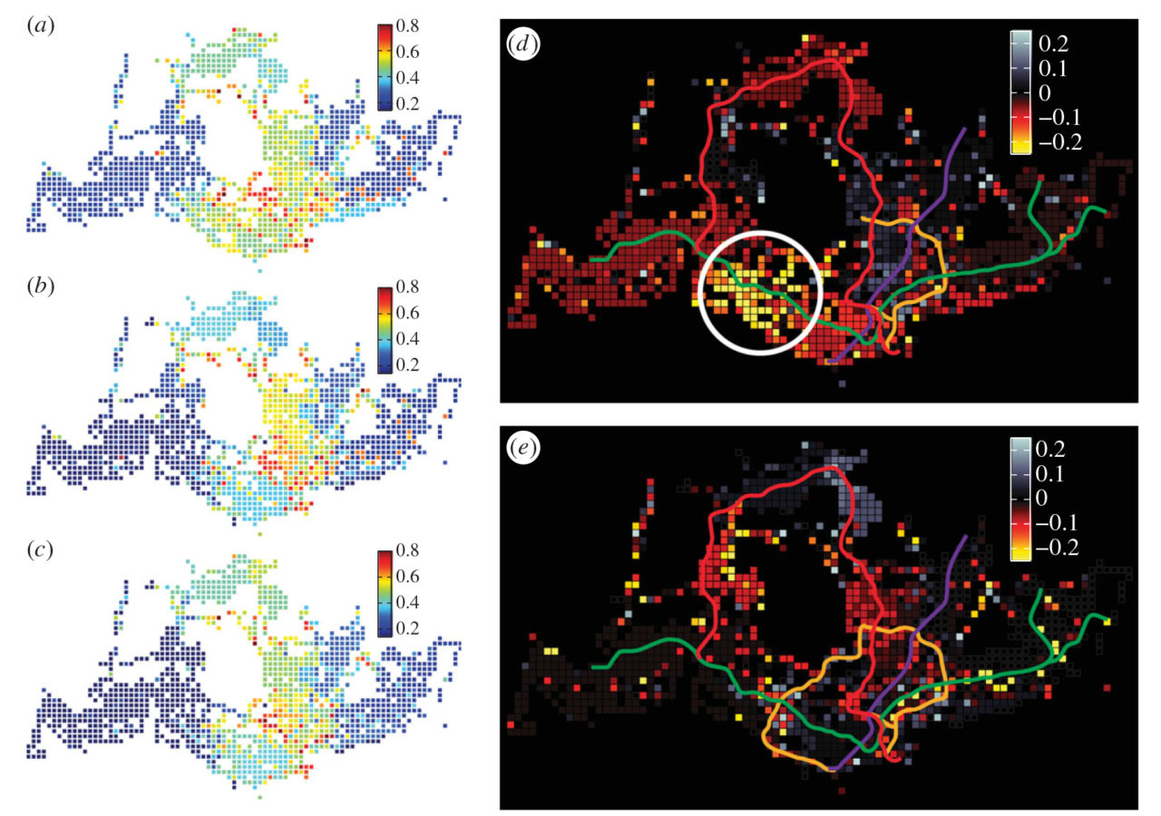
However, the team identified community mutability, which can only be measured via highly disaggregated mobility traces, as a highly sensitive measure that is able to uncover the subtle yet global effects of the infrastructure project in the evolution of spatial interactions. The team found that mutability is a highly sensitive index to detect the change in human mobility caused by major transportation infrastructure, showing the evolving borders in urban community structure and with this the way people interact to shape, sustain or transform a city.

The completion of the CCL enables travellers to re-identify their desired destinations collectively with lower transport cost, making the community structure more consistent. These changes in locality are dynamic and characterised over short time scales, offering a different approach to identify and analyse the long-term impact of new infrastructures on cities and their evolution dynamics.

The team believes that the findings and analysis framework offers analytical tools to better sense the evolution of mobility patterns in cities, providing insights for urban planning, modeling and understanding the evolution of cities through the coupling of infrastructure and interaction networks.

Lijun Sun is a researcher from the Mobility and Transportation Planning module of the Future Cities Laboratory of the Singapore-ETH Centre. His main focus lies on data-driven transport modeling, public transport, human mobility, and behaviour and cities and citizens.

Image: The figure shows spatial distribution of overall mutability index over three years: (A) 2011 (B) 2012 and (C) 2013. Panel (D) and (E) show the difference from 2011 to 2012 and from 2012 to 2013, respectively.

Share this...
  • Facebook
  • Linkedin
  • Whatsapp
  • Email
Questo contributo è stato pubblicato nella seguente newsletter:

24 | Dezember 2014: Energie(wende)

  • Sharing is Saving: How collaborative mobility can reduce the impact of energy consumption for transportation
  • Die Rolle der Raumplanung bei der Transformation der elektrischen Energieversorgung
  • Visuell-akustische Simulationen zur umfassenderen Standortevaluation von Windparks
  • Strategies for energy efficiency of rail freight transportation
  • Electric Vehicle Simulation
  • Quantifying long-term evolution of intra-urban spatial interactions
Kurzmeldung
  • 3D GIS zur Planung von elektrischen Versorgungsnetzen
  • Elektrifizierung des nicht-spurgeführten städtischen öffentlichen Verkehrs – Ein betrieblicher Systemvergleich
  • Zernez Energia 2020 gewinnt Sonderpreis
  • Der Raum im Städtebau 1890–1930: Positionen in Theorie und Praxis
  • Die Systematisierung städtebaulichen Wissens: Eine wissenschaftsgeschichtliche Untersuchung städtebaulicher Manuale in der Gründungsphase der Disziplin Städtebau (1875-1930)
  • Urbane Profile
  • The Public Spectacle
Publikationen
  • Shape Grammars Overview and Assessment for Transport and Urban Design – Review, Terminology, Assessment, and Application
  • Partial proportional odds model: An alternate choice for analyzing pedestrian crash injury severities
  • The City as Resource
  • Effects of non-aeronautical activities at airports on the public transport access system: A case study of Zurich Airport
  • Siedlungsflächenmanagement Schweiz. Problemorientierte Flächenübersichten als zentrale Grundlage für eine Siedlungsentwicklung nach innen
  • Enzyklopädie zum gestalteten Raum. Im Spannungsfeld zwischen Stadt und Landschaft
  • Back to Form. Landscape Architecture and Representation in Europe after the Sixties
  • Landschaft als Wunderkammer. Fragen nach einer Haltung. / Landscape as a Cabinet of Curiosities. In Search of a Position

Cattedre

Prof. Dr. Bryan T. Adey
Prof. Dr. Kay W. Axhausen
Prof. Dr. Tom Avermaete
Prof. Maria Conen
Prof. Dr. Francesco Corman
Dr. Jennifer Duyne Barenstein
Prof. Teresa Galí-Izard
Prof. Dr. Adrienne Grêt-Regamey
Prof. Dr. Guillaume Habert
Prof. Dr. Eva Heinen
Prof. Damian Jerjen
Prof. Dr. David Kaufmann
Prof. Hubert Klumpner
Dr. Anastasios Kouvelas
Prof. Freek Persyn
Prof. Dr. Christian Schmid
Prof. Milica Topalovic
Prof. Martina Voser

Contatto

Indirizzo
ETH Zürich
NSL – Netzwerk Stadt und Landschaft
Stefano-Franscini-Platz 5
HIL H 44.2
8093 Zürich

Direzione NSL
Direttore: Prof. Dr. David Kaufmann
Vicedirettrice: Prof. Milica Topalovic

Ufficio di coordinamento NSL
Claudia Gebert
Telefono: +41 (0)44 633 36 33


Iscriviti alla newsletter della NSL

Redazione disP

Caporedattrice
Dr. sc. techn. Martina Koll-Schretzenmayr, pianificatrice territoriale ETH/NDS,
Telefono +41 (0)44 633 29 47

Indirizzo
ETH Zürich
Redaktion disP
NSL – Netzwerk Stadt und Landschaft
Stefano-Franscini-Platz 5
HIL H 33.3
8093 Zürich
Fax +41 (0)44 633 12 15
E-Mail

Archivio NSL (gta)

Archivio storico e di ricerca per l’architettura
del paesaggio e la pianificazione ambientale svizzere

Richieste di consultazione

Indirizzo
ETH Zürich
NSL Archive (gta)
Stefano-Franscini-Platz 5
HIL C 65.2
CH-8093 Zurich


Protezione dei dati