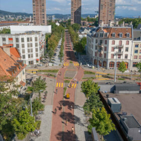
How can cities plan safer cycling routes without reliable data on cycling infrastructure? Using machine learning on aerial imagery, we generated a comprehensive historical dataset of cycling-specific infrastructure across Switzerland’s largest urban areas. This opens new possibilities for planning and research.
Encouraging cycling as a sustainable and safe mode of transportation requires a clear picture of where infrastructure exists – and where more is needed. Until now, data on cycling infrastructure in Switzerland has been fragmented, inconsistent across administrative boundaries, and often incomplete at intersections, where safety improvements matter most. Consistently connecting historical crash data to road infrastructure is currently not easily done.
Ten Types of Cycling-relevant Infrastructure Identified
Our work uses machine learning to fill these gaps. By training an object detection model on high-resolution aerial images, we identified ten types of cycling-relevant infrastructure, from bicycle lanes and pictograms to crosswalks and waiting spaces at intersections. Applying the method to the ten largest Swiss agglomerations, we created a dataset that goes back over 25 years and is consistent for all analysed agglomerations.
The results show a steady expansion of cycling infrastructure over the last two decades, with certain agglomerations standing out as having relatively more cycling infrastructure than others. Different types of roads also tend to be better equipped, depending on their size and the level of government responsible for maintaining the road. Importantly, the dataset includes historical changes, allowing for the study of how infrastructure developments relate to crash risks or shifts in cycling demand. The full results will be published in an academic journal soon.
Existing Aerial Imagery can be Transformed into Valuable Planning Data
This approach demonstrates how existing aerial imagery can be transformed into valuable planning data. As aerial imagery is widely available beyond Switzerland, our approach offers a transferable method for researchers and policymakers worldwide who aim to support cycling as part of climate-friendly urban mobility strategies.
 David Zani is a researcher at Professor Bryan Adey’s Chair of Infrastructure Management at ETH Zurich. His work focuses on infrastructure appraisals and decision-making. Contact on LinkedIn
This project was undertaken in collaboration with Sebastiano Papini at D-MTEC.