NSL – Netzwerk Stadt und Landschaft ETH Zürich
  • Projekte
      • Projekte der Professuren
        • Prof. Dr. Bryan T. Adey | Infrastrukturmanagement
        • Prof. Dr. Tom Avermaete | Geschichte und Theorie des Städtebaus
        • Prof. Dr. Kay W. Axhausen | Verkehrsplanung
        • Prof. Dr. Francesco Corman | Verkehrssysteme
        • Prof. Teresa Galí-Izard | Professur Being Alive
        • Prof. Dr. Adrienne Grêt-Regamey | Planung von Landschaft und Urbanen Systemen
        • Prof. Dr. Eva Heinen | Verkehrs- und Mobilitätsplanung
        • Prof. Dr. David Kaufmann | Raumentwicklung und Stadtpolitik
        • Prof. Hubert Klumpner | Architektur und Städtebau
        • Dr. Anastasios Kouvelas | Strassenverkehrstechnik
        • Prof. Dr. Christian Schmid | Soziologie
        • Prof. Milica Topalovic | Architektur und Territorialplanung
        • Dr. Jennifer Duyne Barenstein | ETH Wohnforum – ETH CASE
        • NSL-Archiv
      • Ehemalige Professuren
      • NSL Kolloquienreihe – Präsentation herausragender Arbeit zu einem von der einladenden Professur festgelegten Thema.
      • NSL Projekte
          • E-Bike City
          • Future Cities Lab Global
          • Urbane Potentiale und Strategien in metropolitanen Territorien
 – am Beispiel des Metropolitanraums Zürich (NFP65)
          • Large-scale Virtualization and Modeling Lab (LVML)
      • NSL Foren
        • NSL Forum & Cycling Research Board
        • NSL Forum: Pandemie? Mitten im Klimawandel. Was bedeutet das für die räumliche Entwicklung der Schweiz? Ein Dialog.
    Close
  • Lehre
    • Lehrangebote
      • Bachelor- und Masterstudium Departement ARCH
      • Bachelor- und Masterstudium Departement BAUG
      • MSc Raumentwicklung und Infrastruktursysteme
      • MAS/CAS in Regenerative Materials
      • CAS in Regenerative Systems: Sustainability to Regeneration
      • MAS/CAS Raumentwicklung
      • MAS Urban and Territorial Design
      • MAS in Housing
      • Doctoral Programme in Landscape and Urban Studies
      • Die Kenntnis der für die räumlichen Entwicklungen massgebenden Kräfte und deren Zusammenwirken wie auch die Fähigkeit zur Entwicklung von Lösungsstrategien für räumliche Problemstellungen sind zentrale Voraussetzungen für verantwortungsvolles und erfolgreiches Ausüben planerischer Funktionen im Dienste öffentlicher Gemeinwesen und privater Unternehmen. Entsprechend bedeutend ist die universitäre Aus-, Weiter- und Fortbildung im Bereich der Raum-, Stadt- und Landschaftsplanung. An der ETH Zürich werden in diesem Bereich seit 1965 Fortbildungs-Kurse und Nachdiplom-Studiengänge (NDS, heute MAS) angeboten. Träger ist das NSL (Netzwerk Stadt und Landschaft).
    Close
  • Publikationen
    • Cover NL 65Newsletter – Das NSL führt Fachleute der ETH Zürich zusammen und pflegt den Dialog mit weiteren Kreisen, die sich mit Fragen rund um Stadt und Landschaft befassen oder sich dafür interessieren.
    • A map describing the different phases of India’s neoliberal highway programme. Source: The author.Ausgewählte Publikationen der NSL–Professuren – Eine vollständige Publikationsliste mit erweiterten Suchfunktionen ist über den folgenden Link zu erreichen:
      • ETH Zürich Research Collection
    • disP – The Planning Review – Die interdisziplinäre wissenschaftliche Zeitschrift behandelt Themen aus den Bereichen Raumentwicklung, Stadtplanung/Städtebau, Landschafts- und Umweltplanung, Landschaftsarchitektur, Regional- und Umweltökonomie sowie Verkehrsplanung.
      • Angaben für Autor:innen
      • Types of Articles
      • Verlag
      • Richtlinien für Buchbesprechungen
      • Redaktion
      • Aktuelle Ausgabe
    • DELUS Cover Issue 1DELUS – Journal for Landscape and Urban Studies – DELUS ist eine jährliche Publikation des Instituts für Stadt- und Landschaftsforschung der ETH Zürich
    Close
  • Aktuell
  • Kontakt
      • de
        • en
        • fr
        • it
      • Search

    • Close
      • de
        • en
        • fr
        • it

Digital Planning Tools and «Focal Practices»

Neighbour preference calculation. © U-TT, ETH Zurich.

The experiences gained from designing and implementing digital tools that aim to replicate an urban development methodology allows a critical reflection on the limits of emerging planning technology. These limits become clear when assessing how successful the technology is in enhancing the «focal practices» (Borgmann 1984) of participants in the planning process.

Enhancement or Control

Exercising meaningful ways for open, democratic contributions to urban planning could be considered focal practices of contemporary citizenry. Enhancing such practice is at the forefront of reimagining how digital tools could reshape the city. However, current planning technologies – and the acts of employing them – occupy a contested field taut between the experience of user-oriented participation and technical-oriented efficiency and performance. In other words, technology can either enhance the ability to engage, connect and act within the material world or tend to guide procedures toward normative outcomes and pre-programed optimisation models. The interest therefore lies in designing planning technologies that offer tangible links and responses between rich experiences of creative agency and socially agreeable quantitative indicators.

Planning Control

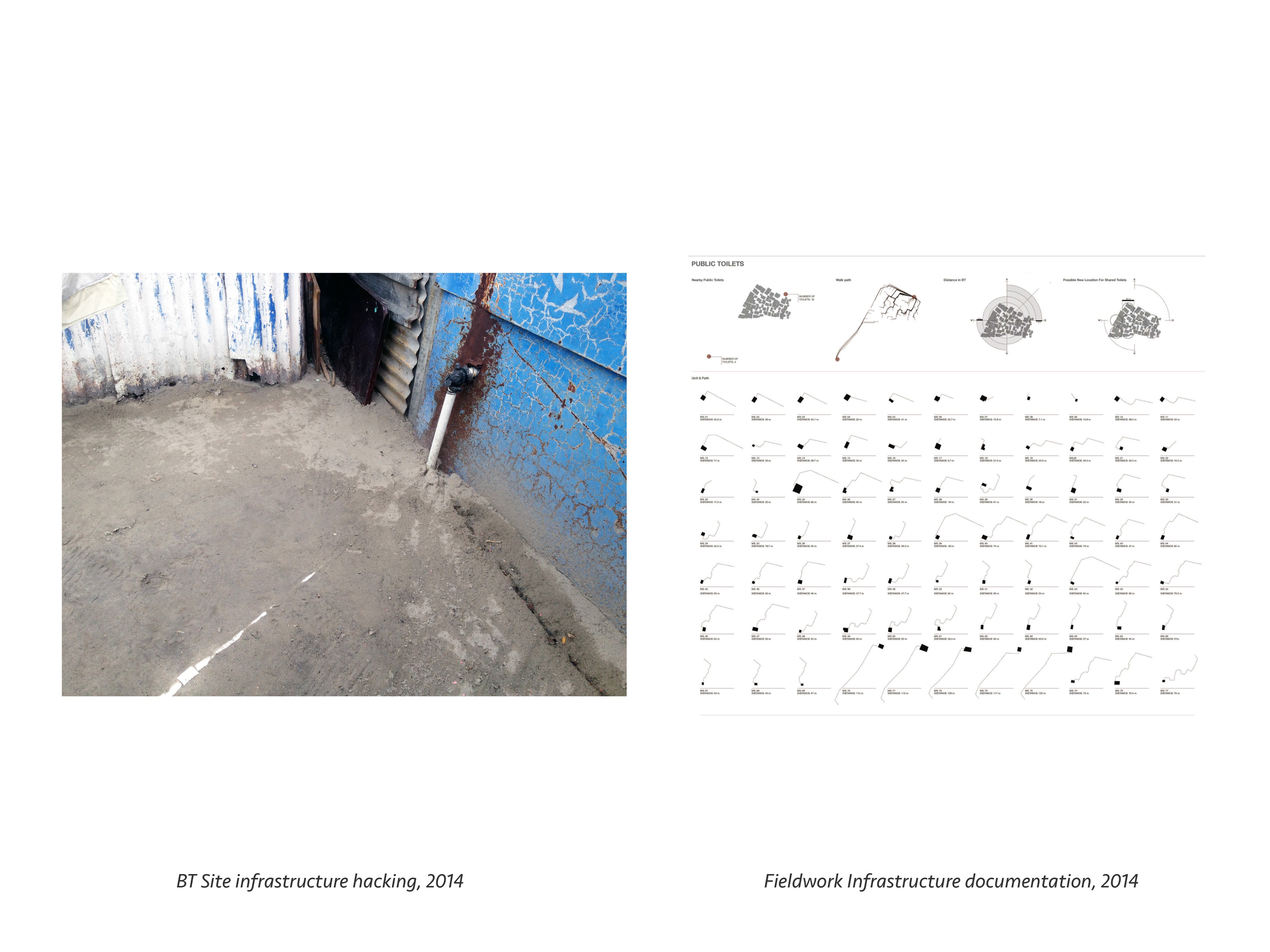
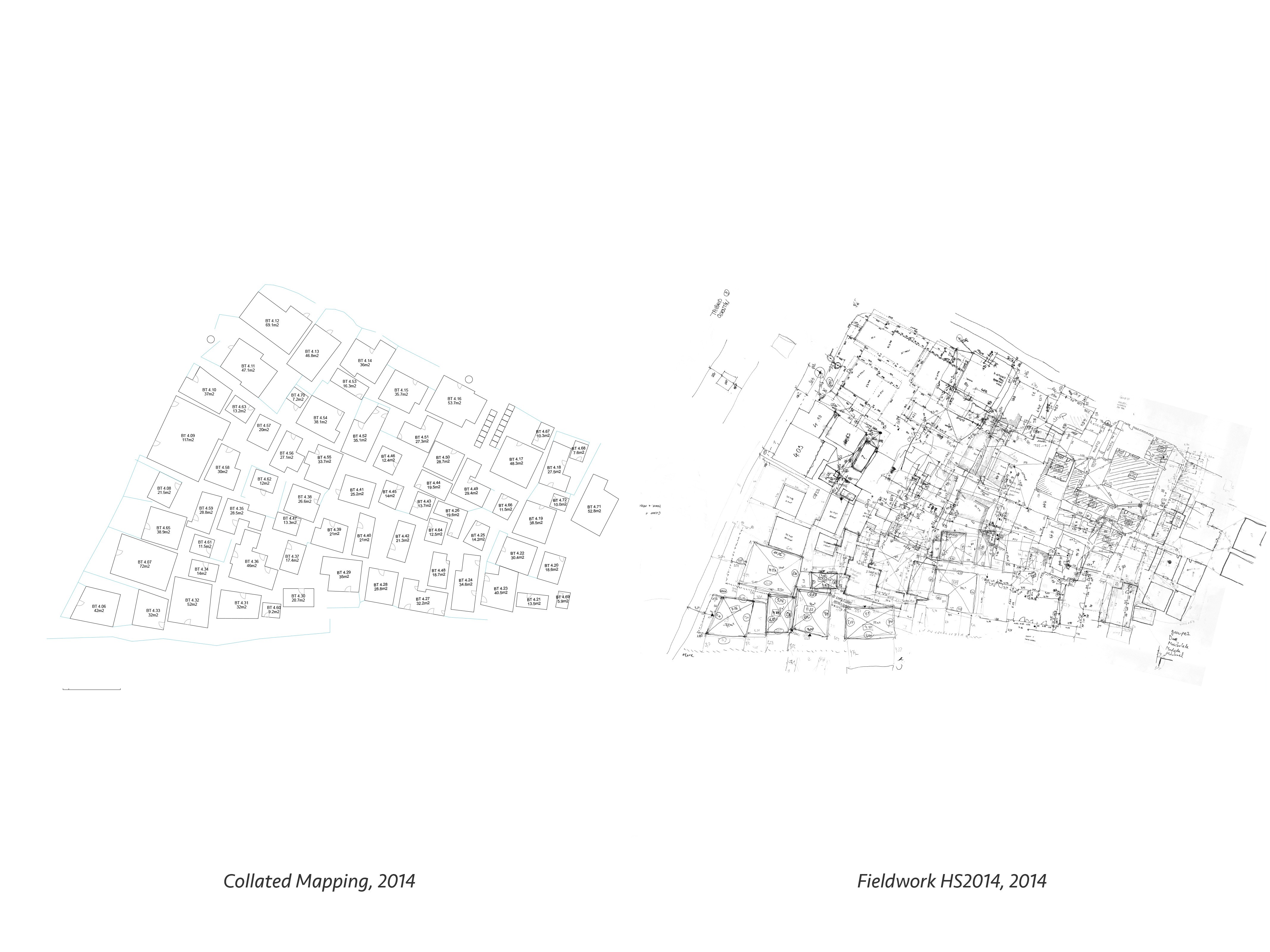
The cadastral system of land registration and associated modern tools for land management embody sets of technologies geared toward the documentation and control of land. This has served to increasingly abstract and optimise its commodity value, benefiting and legitimising certain practices that align to this system of value and exclude those that do not. Accordingly, informal settlements also possess forms of planning and management that fulfil similar goals of control and commodification. These practices are however enforced by non-written agreements and community leadership relations with vastly different scope for development. Studying these systems through participatory digital tools workshops has allowed us to assess the behaviour and perceptions of various stakeholders in relation to urban planning.

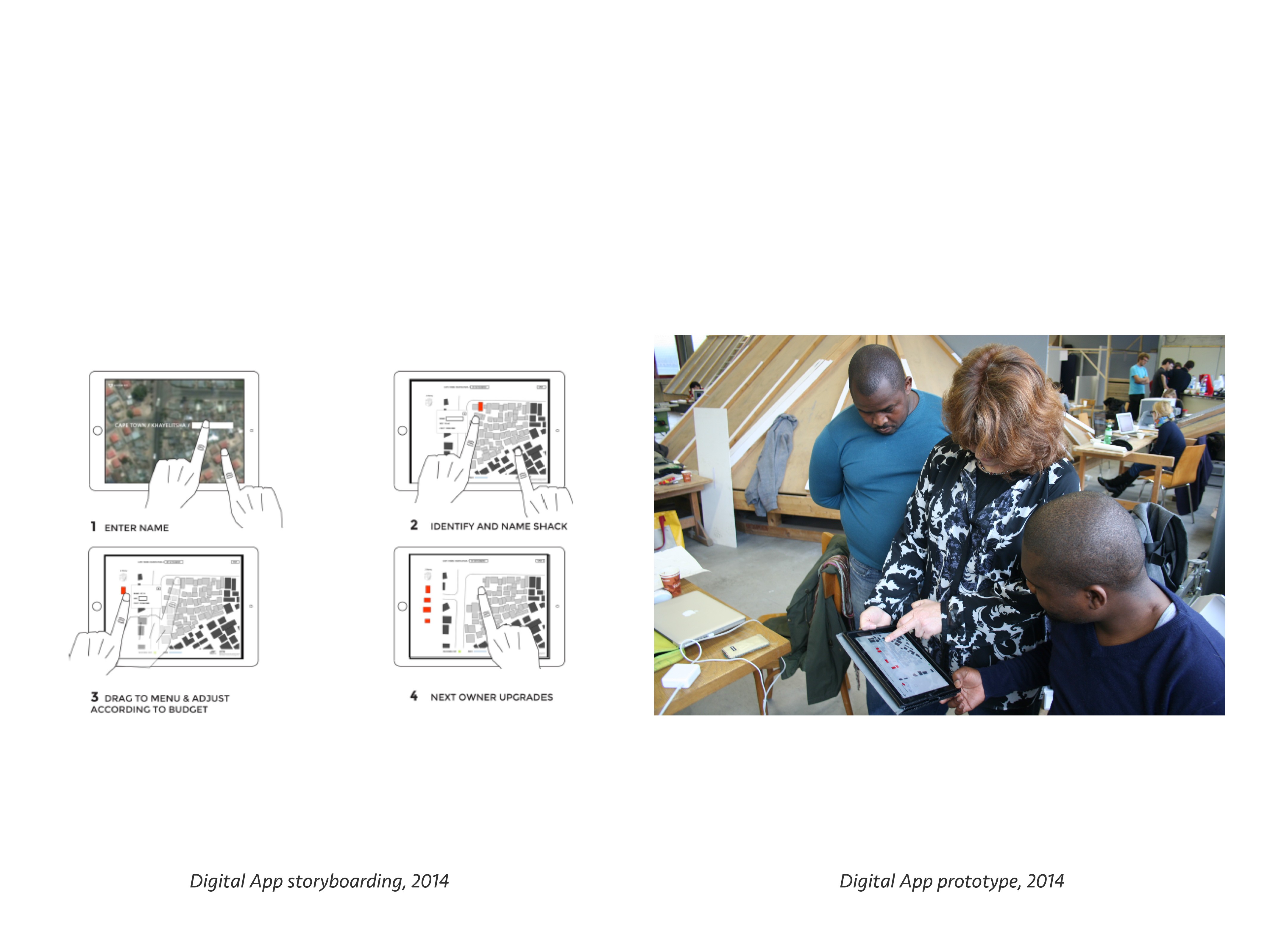
Programming Critical Inputs

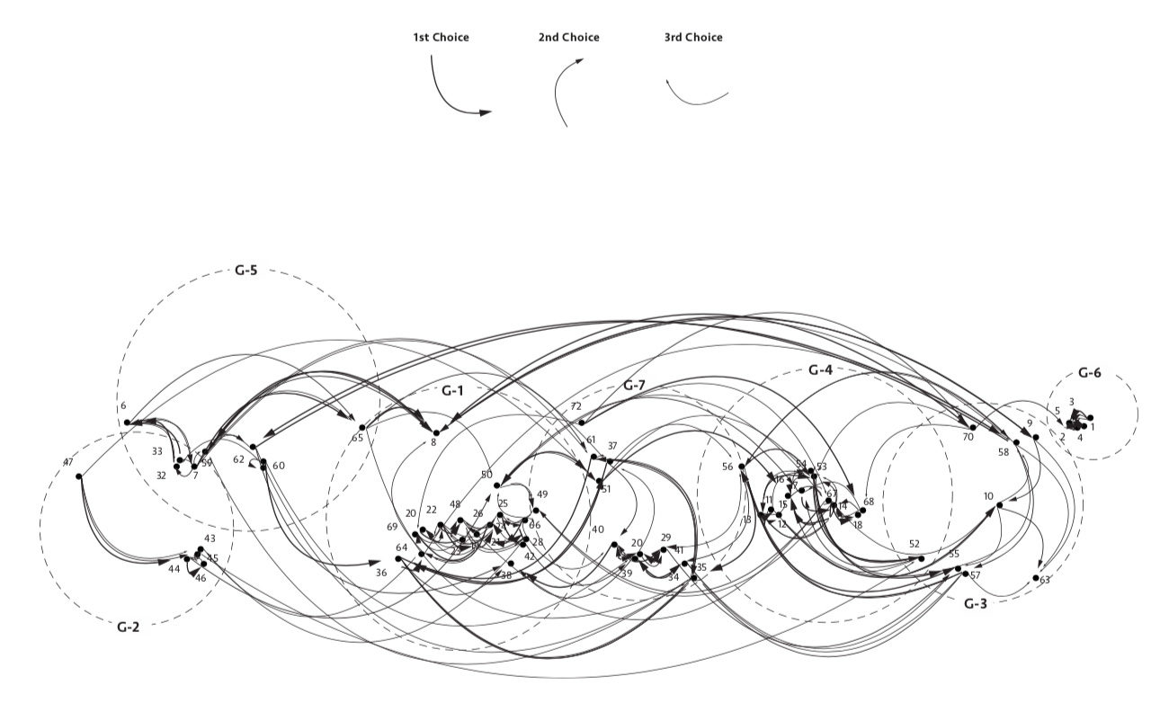
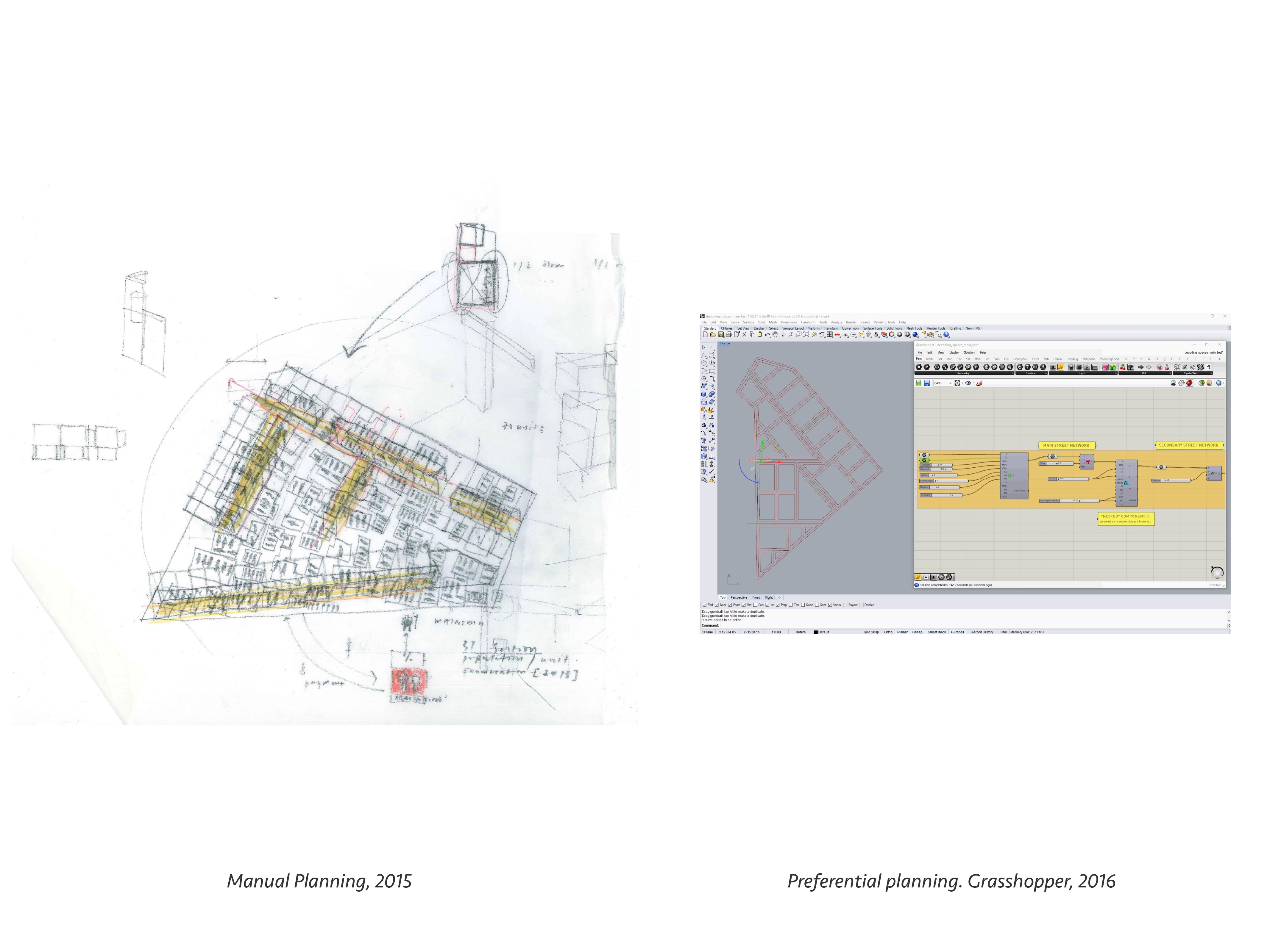
The digital tools have been programmed to allow the synthesis of multi-user input at critical milestones in the urban development methodology. The milestones have been clustered in scales and give shape to the planning outputs through: Individual preferences (neighbour preferences, location preferences, unit size preferences based on micro-finance affordability), Community preferences (existing street networks, public spaces, additional rental stock), Municipal planning frameworks (plot sizes, street widths, proximity to existing infrastructure, zoning and urban use mix)

Vigilance

Focal practices are activities and cultural behaviours with identifiable social value. These respond poorly to ideologies of optimisation. Acknowledging this, we tend to apply the current version of the digital tools mainly for automated urban layout generation, and computational analysis based on pre-defined spatial properties. The results of generated urban simulations are generally treated as points of departure and some cases present didactic examples of excessive optimisation resulting in poor urban design qualities.
Looking forward, a better understanding of human decision-making within complex systems, would greatly enlighten the critical behaviours and motivations of planning. It will also increasingly challenge the idea that decisions on urban spatial quality are best made by citizens and experts in transparent and uniquely human ways.

In Closing

How can individual choice be reconciled with sustainable objectives of long-term urban planning?
Given that technology is not neutral, how can open storyboarding be used to conceive of tools that respond to alternative world-views?
How can social network technology support long-term participation in urban projects?
Can methods developed with digital tools offer transferability to low-tech systems?

Manual – Digital planning tools. © U-TT, ETH Zurich.
Hacked Infrastructure – calculated infrastructure distances. © U-TT, ETH Zurich.
Field work collective mapping – registered occupation plan. © U-TT, ETH Zurich.
Tablet application storyboarding – Tablet application prototype. © U-TT, ETH Zurich.

Scott Lloyd MSc ETH Arch coordinates the Urban-Think Tank Chair of Architecture and Urban Design’s «Empower» project. The project focuses on readjusting urban land in Cape Town, South Africa, by designing and implementing new housing prototypes within a reconfigured urban plan. The IA and MIS chairs at ETH Zurich collaborated on digital planning tools. PHD candidate Michael Walczak is continuing optimisation of the tools. The project is supported by the Swiss Re Foundation.

Share this...
  • Facebook
  • Linkedin
  • Whatsapp
  • Email
Dieser Artikel wurde im folgenden Newsletter publiziert:

40 | Dezember 2018: Technologie beeinflusst Verhalten / Technology Influences Behaviour

  • Induced Demand: Modelling the Potential Impacts of Automated Vehicles in Zurich
  • Digital Planning Tools and «Focal Practices»
  • Führungslose Schweizer Raumentwicklung?
  • Robotic Landscapes: Designing Natural and Robotic Formation Processes in Dynamic Terrains
  • Autonomous Vehicles as Reactivators for Peripheral Areas
Kurzmeldungen
  • Mobility Pricing
  • MntPath – Modelling Future Pathways of Mountain Regions
  • Modelling Place-making to Enable the Transformation of Spaces into Places
  • Smarte Züge ohne Lokführer
Publikationen
  • Sozialraum Hochhaus. Nachbarschaft und Wohnalltag in Schweizer Großwohnbauten
  • Towards an Integrative Approach to Spatial Transformation
  • Soil function assessment for Switzerland
  • Spatial modelling of origin-destination commuting flows in Switzerland
  • disP 54/3, October 2018
Aktuell
  • Ab 2019 leitet Patrick Bonzanigo den MAS Raumplanung ETH
  • MAS, DAS und CAS ETH in Raumplanung 2019/21
  • Master of Advanced Studies ETH Urban Design 2019/20
  • Between the Academy and Activism
  • Future Cities Lab: European – South East Asian Architectural Dialogue
  • Kees Christiaanse erhält den ULI Germany Leadership Award 2018 in der Kategorie Stadtplanung
  • ETH Forum Wohnungsbau: LAND NUTZEN! Wie Städte gerechter wachsen und lebenswert bleiben können
  • Shareland Doctoral Colloquium
  • Summer School in Land-System Science
  • ProbandInnen gesucht – Visualisierungen von Landschaften mit Virtual Reality-Brillen
  • 111 BUNKER. Entdecke das verborgene Zürich!
  • Ausstellungseröffnung mit Diskussionsrunde Masterarbeit «Kanderwasser»
  • Digital Planning Tools and «Focal Practices»
  • Führungslose Schweizer Raumentwicklung?
  • Robotic Landscapes: Designing Natural and Robotic Formation Processes in Dynamic Terrains
  • Autonomous Vehicles as Reactivators for Peripheral Areas

Professuren

Prof. Dr. Bryan T. Adey
Prof. Dr. Kay W. Axhausen
Prof. Dr. Tom Avermaete
Prof. Maria Conen
Prof. Dr. Francesco Corman
Dr. Jennifer Duyne Barenstein
Prof. Teresa Galí-Izard
Prof. Dr. Adrienne Grêt-Regamey
Prof. Dr. Guillaume Habert
Prof. Dr. Eva Heinen
Prof. Damian Jerjen
Prof. Dr. David Kaufmann
Prof. Hubert Klumpner
Dr. Anastasios Kouvelas
Prof. Freek Persyn
Prof. Dr. Christian Schmid
Prof. Milica Topalovic
Prof. Martina Voser

Kontakt

Adresse
ETH Zürich
NSL – Netzwerk Stadt und Landschaft
Stefano-Franscini-Platz 5
HIL H 44.2
8093 Zürich

Leitung NSL
Leiter: Prof. Dr. David Kaufmann
Stv. Leiterin: Prof. Milica Topalovic

Koordinationsstelle NSL
Claudia Gebert
Telefon: +41 (0)44 633 36 33


Für den NSL Newsletter anmelden

Redaktion disP

Leitende Redaktorin
Dr. sc. techn. Martina Koll-Schretzenmayr, Raumplanerin ETH/NDS,
Telefon +41 (0)44 633 29 47

Adresse
ETH Zürich
Redaktion disP
NSL – Netzwerk Stadt und Landschaft
Stefano-Franscini-Platz 5
HIL H 33.3
8093 Zürich
Fax +41 (0)44 633 12 15
E-Mail


NSL Archiv (gta)

Forschungs- und Nachlassarchiv für
Schweizer Landschaftsarchitektur und Raumplanung

Nutzungsanfragen

Adresse
ETH Zürich
NSL Archive (gta)
Stefano-Franscini-Platz 5
HIL C 65.2
CH-8093 Zurich


Datenschutz (Privacy Policy)