NSL – Netzwerk Stadt und Landschaft ETH Zürich
  • Projets
      • Projets des chaires
        • Prof. Dr. Bryan T. Adey | Gestion des infrastructures
        • Prof. Dr. Tom Avermaete | Histoire et théorie de l’urbanisme
        • Prof. Dr. Kay W. Axhausen | Planification des transports
        • Prof. Dr. Francesco Corman | Systèmes de transport
        • Prof. Dr. Adrienne Grêt-Regamey | Aménagement du paysage et des systèmes urbains
        • Prof. Dr. David Kaufmann | Aménagement du territoire et politique urbaine
        • Prof. Hubert Klumpner | Architecture et urbanisme
        • Dr. Anastasios Kouvelas | Ingénierie de trafic et surveillance
        • Prof. Dr. Christian Schmid | Sociologie
        • Prof. Milica Topalovic | Architecture et aménagement du territoire
        • EiR PD Dr. Joris Van Wezemael | Spatial Transformation Laboratories (STL)
        • Prof. em Dr. h. c. Günther Vogt | Architecture du paysage
        • ETH Wohnforum – ETH CASE
        • Archive NSL
      • Colloques NSL – Le colloque NSL consiste en une présentation semestrielle d’un travail remarquable. Le thème est à chaque fois défini par la chaire qui invite.
      • Projets NSL
        • Future Cities Lab Global
        • Stratégies et potentiels urbains dans des territoires métropolitains d’après l’exemple de l’espace métropolitain de Zurich (PNR 65)
        • Landscape Visualization and Modeling Lab (LVML)
      • NSL Forum: Pandemie? Mitten im Klimawandel. Was bedeutet das für die räumliche Entwicklung der Schweiz? Ein Dialog.
      • Anciennes chaires
    Close
  • Enseignement
    • Enseignement
      • Bachelor et mastère, departement ARCH
      • Bachelor et mastère département BAUG
      • MSc en Développement territorial et Systèmes d’infrastructures
      • MAS/CAS Aménagement du territoire
      • MAS Urban and Territorial Design
      • MAS ETH en logement
      • Doctoral Programme in Landscape and Urban Studies
      • La connaissance des forces déterminantes pour les développements territoriaux et de leurs concomitances, mais aussi l'aptitude au développement de stratégies de solutions pour les problématiques territoriales, sont des conditions centrales pour l'exercice responsable et efficace des missions de conception au service de collectivités publiques ou d'entreprises privées. Tout aussi décisifs sont les formations universitaires initiale et continue, et le perfectionnement dans les disciplines d'aménagements territorial, urbain et paysager. L'ETH Zurich propose dans ces disciplines depuis 1965 des cours de formation continue et des cycles d'études post-diplôme (NDS, aujourd'hui MAS). Ils sont organisés par le Réseau Ville et Paysage (NSL).
    Close
  • Publications
    • Newsletter – Le NSL rassemble des experts de l’ETH Zurich et entretient un dialogue avec d’autres milieux qui traitent ou s’intéressent à des questions liées à la ville et au paysage.
    • Publications des chaires du NSL – La liste complète des publications avec option de recherche avancée peut être atteinte via le lien suivant:
      • ETH Zürich Research Collection
    • DISP_58/3_CoverdisP – The Planning Review – La revue scientifique interdisciplinaire traite de thèmes tirés des domaines suivants: aménagement du territoire, aménagement urbain/urbanisme, aménagement du paysage et de l’environnement, architecture du paysage, économie régionale et de l’environnement, mais aussi planification des transports.
      • Publier dans disP – The Planning
      • Editeur
      • Directives pour les comptes-rendus de livres
      • Rédaction
      • Version actuelle
      • facebook
    Close
  • Actualités
  • Contact
      • fr
        • de
        • en
        • it
      • Search

    • Close

Digital Planning Tools and «Focal Practices»

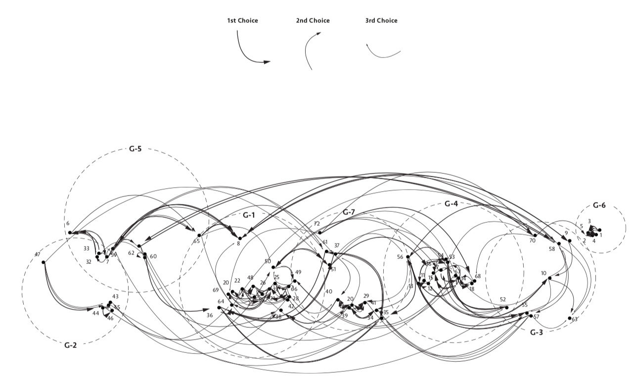
Neighbour preference calculation. © U-TT, ETH Zurich.

The experiences gained from designing and implementing digital tools that aim to replicate an urban development methodology allows a critical reflection on the limits of emerging planning technology. These limits become clear when assessing how successful the technology is in enhancing the «focal practices» (Borgmann 1984) of participants in the planning process.

Enhancement or Control

Exercising meaningful ways for open, democratic contributions to urban planning could be considered focal practices of contemporary citizenry. Enhancing such practice is at the forefront of reimagining how digital tools could reshape the city. However, current planning technologies – and the acts of employing them – occupy a contested field taut between the experience of user-oriented participation and technical-oriented efficiency and performance. In other words, technology can either enhance the ability to engage, connect and act within the material world or tend to guide procedures toward normative outcomes and pre-programed optimisation models. The interest therefore lies in designing planning technologies that offer tangible links and responses between rich experiences of creative agency and socially agreeable quantitative indicators.

Planning Control

The cadastral system of land registration and associated modern tools for land management embody sets of technologies geared toward the documentation and control of land. This has served to increasingly abstract and optimise its commodity value, benefiting and legitimising certain practices that align to this system of value and exclude those that do not. Accordingly, informal settlements also possess forms of planning and management that fulfil similar goals of control and commodification. These practices are however enforced by non-written agreements and community leadership relations with vastly different scope for development. Studying these systems through participatory digital tools workshops has allowed us to assess the behaviour and perceptions of various stakeholders in relation to urban planning.

Programming Critical Inputs

The digital tools have been programmed to allow the synthesis of multi-user input at critical milestones in the urban development methodology. The milestones have been clustered in scales and give shape to the planning outputs through: Individual preferences (neighbour preferences, location preferences, unit size preferences based on micro-finance affordability), Community preferences (existing street networks, public spaces, additional rental stock), Municipal planning frameworks (plot sizes, street widths, proximity to existing infrastructure, zoning and urban use mix)

Vigilance

Focal practices are activities and cultural behaviours with identifiable social value. These respond poorly to ideologies of optimisation. Acknowledging this, we tend to apply the current version of the digital tools mainly for automated urban layout generation, and computational analysis based on pre-defined spatial properties. The results of generated urban simulations are generally treated as points of departure and some cases present didactic examples of excessive optimisation resulting in poor urban design qualities.
Looking forward, a better understanding of human decision-making within complex systems, would greatly enlighten the critical behaviours and motivations of planning. It will also increasingly challenge the idea that decisions on urban spatial quality are best made by citizens and experts in transparent and uniquely human ways.

In Closing

How can individual choice be reconciled with sustainable objectives of long-term urban planning?
Given that technology is not neutral, how can open storyboarding be used to conceive of tools that respond to alternative world-views?
How can social network technology support long-term participation in urban projects?
Can methods developed with digital tools offer transferability to low-tech systems?

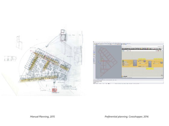
Manual – Digital planning tools. © U-TT, ETH Zurich.
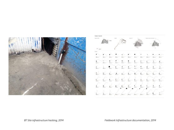
Hacked Infrastructure – calculated infrastructure distances. © U-TT, ETH Zurich.
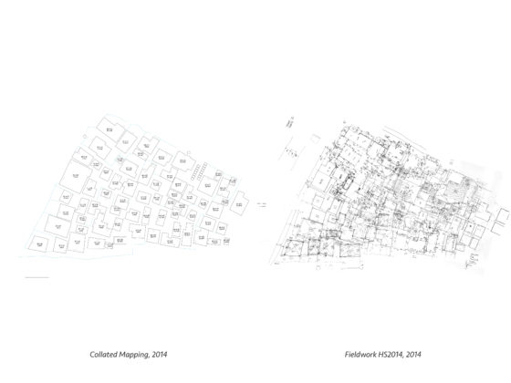
Field work collective mapping – registered occupation plan. © U-TT, ETH Zurich.
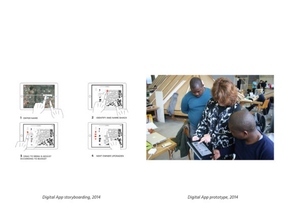
Tablet application storyboarding – Tablet application prototype. © U-TT, ETH Zurich.

Scott Lloyd MSc ETH Arch coordinates the Urban-Think Tank Chair of Architecture and Urban Design’s «Empower» project. The project focuses on readjusting urban land in Cape Town, South Africa, by designing and implementing new housing prototypes within a reconfigured urban plan. The IA and MIS chairs at ETH Zurich collaborated on digital planning tools. PHD candidate Michael Walczak is continuing optimisation of the tools. The project is supported by the Swiss Re Foundation.
Share this...
  • Facebook
  • Twitter
  • Linkedin
  • Email
Cet article a été publié dans le newsletter suivant:

40 | Dezember 2018: Technologie beeinflusst Verhalten / Technology Influences Behaviour

  • Induced Demand: Modelling the Potential Impacts of Automated Vehicles in Zurich
  • Digital Planning Tools and «Focal Practices»
  • Führungslose Schweizer Raumentwicklung?
  • Robotic Landscapes: Designing Natural and Robotic Formation Processes in Dynamic Terrains
  • Autonomous Vehicles as Reactivators for Peripheral Areas
Kurzmeldungen
  • Mobility Pricing
  • MntPath – Modelling Future Pathways of Mountain Regions
  • Modelling Place-making to Enable the Transformation of Spaces into Places
  • Smarte Züge ohne Lokführer
Publikationen
  • Sozialraum Hochhaus. Nachbarschaft und Wohnalltag in Schweizer Großwohnbauten
  • Towards an Integrative Approach to Spatial Transformation
  • Soil function assessment for Switzerland
  • Spatial modelling of origin-destination commuting flows in Switzerland
  • disP 54/3, October 2018
Aktuell
  • MAS, DAS und CAS ETH in Raumplanung 2019/21
  • Summer School in Land-System Science
  • Master of Advanced Studies ETH Urban Design 2019/20
  • Ab 2019 leitet Patrick Bonzanigo den MAS Raumplanung ETH
  • 111 BUNKER. Entdecke das verborgene Zürich!
  • ProbandInnen gesucht – Visualisierungen von Landschaften mit Virtual Reality-Brillen
  • Shareland Doctoral Colloquium
  • ETH Forum Wohnungsbau: LAND NUTZEN! Wie Städte gerechter wachsen und lebenswert bleiben können
  • Future Cities Lab: European – South East Asian Architectural Dialogue
  • Between the Academy and Activism
  • Kees Christiaanse erhält den ULI Germany Leadership Award 2018 in der Kategorie Stadtplanung
  • Ausstellungseröffnung mit Diskussionsrunde Masterarbeit «Kanderwasser»

Chaires

Prof. Dr. Bryan T. Adey
Prof. Dr. Kay W. Axhausen
Prof. Dr. Tom Avermaete
Prof. Maria Conen
Prof. Dr. Francesco Corman
Dr. Jennifer Duyne Barenstein
Prof. Teresa Galí-Izard
Prof. Dr. Adrienne Grêt-Regamey
Prof. Dr. Guillaume Habert
Prof. Dr. David Kaufmann
Prof. Hubert Klumpner
Dr. Anastasios Kouvelas
Prof. Freek Persyn
Prof. Dr. Christian Schmid
Prof. Milica Topalovic
EiR PD Dr. Joris Van Wezemael
Prof. em Dr. h. c. Günther Vogt
ETH Wohnforum – ETH CASE

Contact

Adresse
ETH Zürich
NSL – Netzwerk Stadt und Landschaft
Stefano-Franscini-Platz 5
HIL H 44.2
8093 Zürich

Direction NSL
Directeur: Prof. Hubert Klumpner
Représentant du directeur: Prof. Dr. David Kaufmann

Bureau de coordination NSL
Claudia Gebert
Téléphone: +41 (0)44 633 36 33

Inscrivez-vous à la newsletter NSL

Rédaction disP

Rédactrice responsable
Dr. sc. techn. Martina Koll-Schretzenmayr, aménageuse territoriale ETH/NDS,
Téléphone +41 (0)44 633 29 47

Assistance de rédaction
Téléphone +41 (0)44 633 29 69

Adresse
ETH Zürich
Redaktion disP
NSL – Netzwerk Stadt und Landschaft
Stefano-Franscini-Platz 5
HIL H 33.2
8093 Zürich
Fax +41 (0)44 633 12 15
Adresse électronique

Archive NSL (gta)

Archives de recherche et posthumes pour l’architecture du paysage et l’aménagement du territoire suisses.

Recherche

Adresse
ETH Zürich
NSL Archive (gta)
Stefano-Franscini-Platz 5
HIL C 65.2
CH-8093 Zurich