NSL – Netzwerk Stadt und Landschaft ETH Zürich
  • Projects
      • Projects of the Chairs
        • Prof. Dr. Bryan T. Adey | Infrastructure Management
        • Prof. Dr. Tom Avermaete | History and Theory of Urban Design
        • Prof. Dr. Kay W. Axhausen | Traffic and Transport Planning
        • Prof. Dr. Francesco Corman | Transport Systems
        • Prof. Christophe Girot | Landscape Architecture
        • Prof. Dr. Adrienne Grêt-Regamey | Planning of Landscape and Urban Systems (PLUS)
        • Prof. Dr. David Kaufmann | Spatial Development and Urban Policy
        • Prof. Hubert Klumpner | Architecture and Urban Design
        • Dr. Anastasios Kouvelas | Traffic Engineering and Control
        • Prof. Dr. Christian Schmid | Sociology
        • Prof. Milica Topalovic | Architecture and Territorial Planning
        • EiR PD Dr. Joris Van Wezemael | Spatial Transformation Laboratories (STL)
        • Prof. em Dr. h. c. Günther Vogt | Landscape Architecture
        • ETH Wohnforum – ETH CASE
        • NSL Archive
      • NSL Colloquia – The NSL Colloquia are a bi-annual presentation of exceptional work under a rotating theme determined by the inviting professor.
      • NSL Projects
        • Future Cities Lab Global
        • Urban Potential and Strategies in Metropolitan Territories
 – The Zurich Metropolitan Region as an Example (NFP65)
        • Landscape Visualization and Modeling Lab (LVML)
      • NSL Forum: Pandemie? Mitten im Klimawandel. Was bedeutet das für die räumliche Entwicklung der Schweiz? Ein Dialog.
      • Former Chairs
    Close
  • Teaching
    • Teaching
      • Bachelor and Master Degree Programmes, Department ARCH
      • Bachelor and Master Degree Programmes, Department BAUG
      • MSc in Spatial Development and Infrastructure Systems
      • MAS/CAS Spatial Development
      • MAS Urban and Territorial Design
      • MAS in Housing
      • Doctoral Programme in Landscape and Urban Studies
      • The teaching component of the NSL seeks to impart the knowledge and skills needed to develop the standard strengths of spatial planning and their interaction as well as the ability to develop strategies for the solution of spatial problems. These are central prerequisites for a responsible and successful exercise of planning functions in the service of the public commonwealth and of private companies. Especially important in fufilling these prerequisites is the quality of university-level education: graduate and post-graduate work as well as professional development in spatial, urban and landscape planning. The ETH Zurich has offered programmes such as continuing education courses and post-graduate programmes (NDS, now MAS) since 1965. The NSL (Network City and Landscape) is responsible for these courses and programmes.
    Close
  • Publications
    • Cover NL 56NSL Newsletter – The NSL brings the experts at ETH Zurich together and also maintains a dialogue with other groups that deal with or are interested in issues relating to cities and landscapes.
    • 9783038602767_Agadir_Avermaet_VSPublications of NSL Chairs – A complete list of publications can be reached via the following link, which also includes advanced search capabilities:
      • ETH Zürich Research Collection
    • DISP_58/3_CoverdisP – The Planning Review – The interdisciplinary scientific journal covers the topics of spatial development, urban planning, landscape and environmental planning, landscape architecture, traffic planning, and regional and environmental economics, as well as special issues on specific themes.
      • Publishing in disP – The Planning Review
      • Publisher
      • Book Review Guidelines
      • Editorial Staff
      • Latest Issue
      • facebook
    Close
  • Current
  • Contact
      • en
        • de
        • fr
        • it
      • Search

    • Close

Landscape Visualization and Modeling Lab – LVML

Das neu gegründete departementsübergreifende Landscape Visualization and Modeling Lab ist durch den Einsatz aktueller Technologien im Bereich der Landschaftsvisualisierung und -modellierung ein Kompetenzzentrum für Forschungsprojekte und Anwendungen innerhalb der Lehre. Das computergestützte Lab ist das erste in Europa, das die Verarbeitung von GIS Informationen mit modernen 3D Visualisierungs- und CNC-Modellierungstechniken verknüpft. Es versteht sich als Weiterentwicklung des in den 80er Jahren vom Institut für Orts-, Regional- und Landesplanung (ORL-ETH) in Zusammenarbeit von D-BAUG und D-ARCH initiierten state-of-the-art Visualisierungslab.

Spitzenforschung, hochstehende Feldarbeit und exzellente Ausbildungskurse erfordern, dass die ETH Schritt hält mit den rasanten technischen Entwicklungen in Landschaftsvisualisierung und –modellierung. Deshalb wurde die Infrastruktur zur GIS-basierten 3D Visualisierung und Modellierung der Lehrstühle Prof. Christophe Girot am Institut für Landschaftsarchitektur (ILA) sowie Prof. Adrienne Grêt-Regamey, Planning of Landscape and Urban Systems (PLUS), am Institut für Raum- und Landschaftsentwicklung (IRL) neu konzipiert und das Lab wird mit 16 real-time Workstations und neuer Software ausgestattet.

Die sich schnell entwickelnde Computertechnologie erlaubt heute die Produktion von immer ausgereifteren und realistisch aussehenden virtuellen 3D Landschaften, in denen man sich zunehmend auch bewegen kann. Das Lab ist darauf ausgerichtet, sehr hohe und präzise Designanforderungen in Bezug auf die räumliche Struktur, interaktive Animation und fotorealistische Renderings zu erfüllen. Ein 3D Landschaftsscanner mit 2 km Reichweite erlaubt die Generierung von detaillierten Höhenmodellen, die als Basis für realistische 3D Visualisierungen, akkurate Geländemodellierungen und CNC Fräsbearbeitung zur Ausgabe physischer Modelle dienen.

Durch den Einsatz derselben Technologie in den Fachbereichen Landschaftsplanung und Landschaftsarchitektur werden innovative Ansätze geschaffen. Die aktuellen Einsatzmöglichkeiten am PLUS reichen von der Bewertung optimaler Landnutzungsentwicklungen anhand realistischer 3D Visualisierungen von Ökosystemleistungen bis hin zur Visualisierung generischer Modellierungen neuer urbaner Entwicklungsmuster. Ein besonderer Schwerpunkt liegt auf dem Einsatz der Instrumente zur Einbindung aller relevanten Akteure in den Planungsprozess. Zudem bieten wir seit dem Frühjahrssemester 2010 im Masterstudium einen Trainingskurs für 3D Visualisierungen zur partizipativen Planung an.

Sowohl der entwurfsunterstützende Gebrauch der CAD/CAM Technologie als auch die Implementierung neuer Visualisierungstechnologien stehen innerhalb der Professur für Landschaftsarchitektur seit einigen Jahren im Vordergrund experimenteller Forschung. Durch das neu gegründete Lab können diese Forschungsschwerpunkte professionell weiter entwickelt und akzentuiert werden. Die Technologien des Labs stellen im Bereich des regulären Designsemesters und im Aufbaustudiengang Landschaftsarchitektur eine innovative Ergänzung zur theoretischen und praktischen Auseinandersetzung mit dem öffentlichen Raum der zeitgenössischen Stadt und grossmassstäblicher Landschaftsarchitektur dar.

Forschung und Lehre im LVML werden einen massgeblichen Beitrag zu einer nachhaltigen Entwicklung unserer Umwelt leisten, indem sozio-ökonomische, energetische, ökologische und ästhetische Aspekte bei Landschaftsprojekten gleichermassen in Analyse-, Bewertungs- und Entscheidungsprozesse mit einbezogen werden.

Weitere Informationen zum Lab sind auf den Webseiten der Professuren Girot und Grêt-Regamey zu finden.
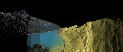
Bild: 3D-Panoptikum bestehend aus Fotografien, Videos und Point Clouds / Professur Girot.

Institut für Landschaftsarchitektur ILA (D-ARCH):
Christophe Girot, Professor für Landschaftsarchitektur,
Pia Fricker,
Alexandre Kapellos,
James Melsom,
Pascal Werner.

Institut für Raum- und Landschaftsentwicklung IRL (D-BAUG):
Adrienne Grêt-Regamey, Professorin für Landschafts- und Umweltplanung PLUS,
Ulrike Wissen Hayek.

Share this...
  • Facebook
  • Twitter
  • Linkedin
  • Email
This article has been published in the following newsletter edition:

05 | März 2010: Bilder und Videos

  • Landscape Visualization and Modeling Lab – LVML
  • Blicklandschaften
  • Die Stadt als Marke – Die Rolle des Brandings in der Stadtplanung
  • Bilderfragen – zum Umgang mit Bildern in Entwurf und Forschung
Kurzmeldungen
  • Investigation of space-time structures in public transport networks and their optimization
  • Forschendes Lernen im Langstrassenquartier
  • Auszeichnung für zeitgenössische Gartenarchitektur
  • Siedlungsentwicklung nach innen – Raum+ Schwyz
Publikationen
  • Grand Urban Rules
  • Die Utopie der Planung
  • Agentenbasierte Simulation für location based services

Chairs

Prof. Dr. Bryan T. Adey
Prof. Dr. Kay W. Axhausen
Prof. Dr. Tom Avermaete
Prof. Dr. Francesco Corman
Dr. Jennifer Duyne Barenstein
Prof. Teresa Galí-Izard
Prof. Christophe Girot
Prof. Dr. Adrienne Grêt-Regamey
Prof. Dr. Guillaume Habert
Prof. Dr. David Kaufmann
Prof. Hubert Klumpner
Dr. Anastasios Kouvelas
Prof. Freek Persyn
Prof. Dr. Christian Schmid
Prof. Milica Topalovic
EiR PD Dr. Joris Van Wezemael
Prof. em Dr. h. c. Günther Vogt
ETH Wohnforum – ETH CASE

Contact

Address
ETH Zürich
NSL – Netzwerk Stadt und Landschaft
Stefano-Franscini-Platz 5
HIL H 44.2
8093 Zürich

NSL Director
Director: Prof. Hubert Klumpner
Deputy Director: Prof. Dr. David Kaufmann

NSL Coordination
Claudia Gebert
Telephone: +41 (0)44 633 36 33

Register for the NSL Newsletter

disP Publication Office

Editor-in-Chief
Dr. sc. techn. Martina Koll-Schretzenmayr, Spatial planner ETH/NDS,
Telephone +41 (0)44 633 29 47

Editorial Assistant
Telephone +41 (0)44 633 29 69

Mailing address
ETH Zürich
Redaktion disP
NSL – Netzwerk Stadt und Landschaft
Stefano-Franscini-Platz 5
HIL H 33.2
8093 Zürich
Fax +41 (0)44 633 12 15
E-Mail


NSL Archive (gta)

Research and Bequest Archive for
Swiss Landscape Architecture and Spatial Planning

Consultation Requests

Mailing address
ETH Zürich
NSL Archive (gta)
Stefano-Franscini-Platz 5
HIL C 65.2
CH-8093 Zurich