NSL – Netzwerk Stadt und Landschaft ETH Zürich
  • Progetti
      • Progetti delle cattedre
        • Prof. Dr. Bryan T. Adey | Gestione delle infrastrutture
        • Prof. Dr. Tom Avermaete | Storia e teoria dell’urbanistica
        • Prof. Dr. Kay W. Axhausen | Pianificazione dei trasporti
        • Prof. Dr. Francesco Corman | Sistemi di trasporto
        • Prof. Teresa Galí-Izard | Chair of Being Alive
        • Prof. Dr. Adrienne Grêt-Regamey | Pianificazione paesaggistica e sistemi urbani
        • Prof. Dr. Eva Heinen | Pianificazione dei trasporti e della mobilità
        • Prof. Dr. David Kaufmann | Sviluppo del territorio e politica urbana
        • Prof. Hubert Klumpner | Architettura e Urbanistica
        • Dr. Anastasios Kouvelas | Ingegneria e controllo del traffico
        • Prof. Dr. Christian Schmid | Sociologia
        • Prof. Milica Topalovic | Architettura e pianificazione territoriale
        • Dr. Jennifer Duyne Barenstein | ETH Wohnforum – ETH CASE
        • NSL-Archiv
      • Ex cattedre
      • Colloqui NSL – Il colloquio NSL è una presentazione semestrale di lavori eccellenti. Il tema viene stabilito di volta in volta dal professore che presenta l’invito.
      • Progetti NSL
          • E-Bike City
          • Future Cities Lab Global
          • Urbane Potentiale und Strategien in metropolitanen Territorien
 – am Beispiel des Metropolitanraums Zürich (NFP65)
          • Large-scale Virtualization and Modeling Lab (LVML)
      • NSL Forum
        • NSL Forum & Cycling Research Board
        • NSL Forum: Pandemie? Mitten im Klimawandel. Was bedeutet das für die räumliche Entwicklung der Schweiz? Ein Dialog.
    Close
  • Insegnamento
    • Insegnamento
        • Bachelor e Master dipartimento ARCH
        • Bachelor e master dipartimento BAUG
        • MSc in Sviluppo territoriale e sistemi infrastrutturali
        • MAS/CAS in Regenerative Materials
        • CAS ETH in Regenerative Systems: dalla sostenibilità alla rigenerazione
        • MAS/CAS Pianificazione del territorio
        • MAS Urban and Territorial Design
        • MAS ETH in edilizia abitativa
        • Doctoral Programme in Landscape and Urban Studies
      • La conoscenza delle forze decisive per lo sviluppo del territorio e la loro interazione, nonché la capacità di sviluppo di strategie risolutive per problematiche territoriali rappresentano i presupposti centrali per lo svolgimento responsabile ed efficace di funzioni di pianificazione al servizio della collettività e di imprese private. Altrettanto importanti sono la formazione, il perfezionamento e l'agggiornamento universitari nel settore della pianificazione territoriale, urbana e del paesaggio. Dal 1965 l'ETH di Zurigo offre corsi di aggiornamento e percorsi di studi post-laurea (NDS, oggi MAS) in questo ambito. I corsi sono gestiti dalla Rete Scientifica Città e Paesaggio (NSL).
    Close
  • Pubblicazioni
    • Cover NL 65Newsletter – NSL riunisce esperti dell’ETH di Zurigo e cura il dialogo con altri ambienti che si occupano o si interessano di questioni relative alla città e al paesaggio.
    • A map describing the different phases of India’s neoliberal highway programme. Source: The author.Pubblicazioni delle cattedre di NSL – Un elenco completo delle pubblicazioni con funzioni di ricerca avanzate è disponibile al seguente link:
      • ETH Zürich Research Collection
    • disP – The Planning Review – La rivista scientifica interdisciplinare tratta temi legati a sviluppo territoriale, urbanistica, pianificazione paesaggistica e ambientale, architettura del paesaggio, economia regionale e ambientale e pianificazione del traffico.
      • Istruzioni per autori / autrici
      • Types of Articles
      • Editore
      • Guida per la stesura di recensioni letterarie
      • Redazione
      • Ultimo numero
      • facebook
    • DELUS Cover Issue 1DELUS – Journal for Landscape and Urban Studies – DELUS è una pubblicazione annuale dell’Istituto di studi urbani e del paesaggio dell’ETH di Zurigo.
    Close
  • Attualità
  • Contatto
      • it
        • de
        • en
        • fr
      • Search

    • Close
      • it
        • de
        • en
        • fr

Advancing Tools and Methods for Mobility and Transportation Planning | Module VIII

The flow of people and goods within and through city areas is a fundamental dimension of contemporary urban design, planning and management. Understanding, modelling and simulating such flows in a high-density city such as Singapore was at the core of our research.

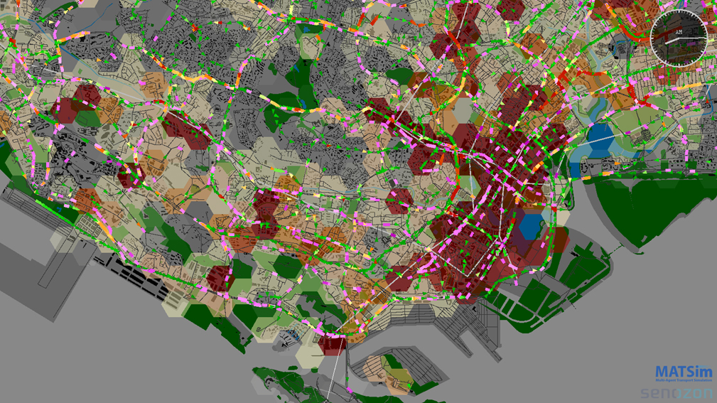
To this end, we implemented and continue to improve a full-scale implementation of the agent-based transport simulation software MATSim for the case of Singapore. We not only enhanced the performance and functionality of this open-source simulation software, but also developed new approaches to improve the use of public transport smart card data to model the spatial dynamics of work activities.

To make MATSim more accessible for practitioners, we developed a new decision support system for transport planning. At the heart of the system is a spatial database that integrates the various data sources required for modelling and manages the input and output of the transport simulation. Various visualization tools connecting to that database help both researchers and planners to better analyse and communicate their findings and plans to different stakeholders.

The availability of public transport smart card data also opened a new strand of research. First, we applied such data to better understand the impact of different bus types and occupancy levels on the time it takes for people to get on and off vehicles. Next, we described the travel time between stops as a function of various attributes of the road network and the built environment. By integrating such models and travel demand derived from smart card data into the simulation tool MATSim, we can turn Big Data into Smart Data, which allows us to predict the impact of redesigning existing or new public transport lines with regard to service reliability and crowdedness.

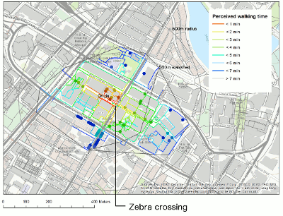
In collaboration with the Urban Redevelopment Authority, we also engaged in a research project to study pedestrian behaviour and quantify the walkability of Singapore’s city centre. With meticulous effort we mapped various characteristics of the built environment that impact the walking quality, such as availability of activated frontages, width of the walkway or cover from sun and rain. The research clearly demonstrated that such urban design qualities not only impact pedestrian’s satisfaction but also their route choice behaviour. To make those findings applicable in planning practice, we also developed a GIS tool that allows the evaluation of the impact of new pedestrian infrastructure and planning policies.

If you are interested in learning more about these three research projects, please refer to the movies:

MATSim Singapore
Big Data MATSim
Embracing Walkability

Researchers for module VIII are Prof. Dr. Kay W. Axhausen, Dr. Alexander Erath, Artem Chakirov, Pieter J. Fourie, Sergio Ordonez, Lijun Sun, Teresa Tan, Michael van Eggermond, Atizaz Ali, and Basil Vitins.


NL27: Advancing Tools and Methods for Mobility and Transportation Planning | Module VIII
Case study to evaluate the impact of replacing a pedestrian overhead bridge with a conventional zebra crossing. The walkability tool allows computing and comparing the walksheds for the different planning scenarios.
Share this...
  • Facebook
  • Linkedin
  • Whatsapp
  • Email
Questo contributo è stato pubblicato nella seguente newsletter:

27 | September 2015: Abschlussbericht Future Cities Laboratory FCL

  • ETH’s Architecture and Urbanization Outpost in Singapore: An Interdisciplinary Culture of Collaboration
  • Diverse Neighbourhoods & Airport Regions | Module IV
  • Planetary Urbanization in a Comparative Perspective | Module V
  • Territorial Organization | Module VI
  • Landscape Ecology | Module VII
  • Advancing Tools and Methods for Mobility and Transportation Planning | Module VIII
  • Prof. Dr. Adrienne Grêt-Regamey ist neue NSL-Leiterin
Kurzmeldungen
  • The Hinterland of Contemporary Cities
  • Alternative Building Materials
  • Plans and Politics
Publikationen
  • The Renaissance of Nakta Mountain
  • Gesamtwirtschaftliche Effekte des öffentlichen Verkehrs mit besonderer Berücksichtigung der Verdichtungs- und Agglomerationseffekte
  • System dynamics of urban traffic based on its parking-related-states
  • Theoretikerinnen des Städtebaus. Texte und Projekte für die Stadt
  • Generische Beschreibung von Eisenbahnbetriebsprozessen
  • radikal normal. Positionen zur Architektur der Stadt
  • Habitat Marocain Documents: Dynamics Between Formal and Informal Housing
  • Brachlandschaften / Wastelands

Cattedre

Prof. Dr. Bryan T. Adey
Prof. Dr. Kay W. Axhausen
Prof. Dr. Tom Avermaete
Prof. Maria Conen
Prof. Dr. Francesco Corman
Dr. Jennifer Duyne Barenstein
Prof. Teresa Galí-Izard
Prof. Dr. Adrienne Grêt-Regamey
Prof. Dr. Guillaume Habert
Prof. Dr. Eva Heinen
Prof. Damian Jerjen
Prof. Dr. David Kaufmann
Prof. Hubert Klumpner
Dr. Anastasios Kouvelas
Prof. Freek Persyn
Prof. Dr. Christian Schmid
Prof. Milica Topalovic
Prof. Martina Voser

Contatto

Indirizzo
ETH Zürich
NSL – Netzwerk Stadt und Landschaft
Stefano-Franscini-Platz 5
HIL H 44.2
8093 Zürich

Direzione NSL
Direttore: Prof. Dr. David Kaufmann
Vicedirettrice: Prof. Milica Topalovic

Ufficio di coordinamento NSL
Claudia Gebert
Telefono: +41 (0)44 633 36 33


Iscriviti alla newsletter della NSL

Redazione disP

Caporedattrice
Dr. sc. techn. Martina Koll-Schretzenmayr, pianificatrice territoriale ETH/NDS,
Telefono +41 (0)44 633 29 47

Indirizzo
ETH Zürich
Redaktion disP
NSL – Netzwerk Stadt und Landschaft
Stefano-Franscini-Platz 5
HIL H 33.3
8093 Zürich
Fax +41 (0)44 633 12 15
E-Mail

Archivio NSL (gta)

Archivio storico e di ricerca per l’architettura
del paesaggio e la pianificazione ambientale svizzere

Richieste di consultazione

Indirizzo
ETH Zürich
NSL Archive (gta)
Stefano-Franscini-Platz 5
HIL C 65.2
CH-8093 Zurich


Protezione dei dati