NSL – Netzwerk Stadt und Landschaft ETH Zürich
  • Progetti
      • Progetti delle cattedre
        • Prof. Dr. Bryan T. Adey | Gestione delle infrastrutture
        • Prof. Dr. Tom Avermaete | Storia e teoria dell’urbanistica
        • Prof. Dr. Kay W. Axhausen | Pianificazione dei trasporti
        • Prof. Dr. Francesco Corman | Sistemi di trasporto
        • Prof. Christophe Girot | Architettura del paesaggio
        • Prof. Dr. Adrienne Grêt-Regamey | Pianificazione paesaggistica e sistemi urbani
        • Prof. Dr. David Kaufmann | Sviluppo del territorio e politica urbana
        • Prof. Hubert Klumpner | Architettura e Urbanistica
        • Dr. Anastasios Kouvelas | Ingegneria e controllo del traffico
        • Prof. Dr. Christian Schmid | Sociologia
        • Prof. Milica Topalovic | Architettura e pianificazione territoriale
        • EiR PD Dr. Joris Van Wezemael / Dr. Markus Nollert | Spatial Transformation Laboratories (STL)
        • Prof. Dr. h. c. Günther Vogt | Architettura del paesaggio
        • ETH Wohnforum – ETH CASE
        • Archivio NSL
      • Colloqui NSL – Il colloquio NSL è una presentazione semestrale di lavori eccellenti. Il tema viene stabilito di volta in volta dal professore che presenta l’invito.
      • Progetti NSL
        • Future Cities Lab Global
        • Urbane Potentiale und Strategien in metropolitanen Territorien
 – am Beispiel des Metropolitanraums Zürich (NFP65)
        • Landscape Visualization and Modeling Lab (LVML)
      • NSL Forum
      • Ex cattedre
    Close
  • Insegnamento
    • Insegnamento
      • Bachelor e Master dipartimento ARCH
      • Bachelor e master dipartimento BAUG
      • MSc in Sviluppo territoriale e sistemi infrastrutturali
      • DAS/CAS in ingegneria dei trasporti
      • MAS/DAS/CAS Pianificazione del territorio
      • MAS Urban and Territorial Design
      • MAS ETH in edilizia abitativa
      • Dottorato di ricerca in Studi urbani e del paesaggio
      • La conoscenza delle forze decisive per lo sviluppo del territorio e la loro interazione, nonché la capacità di sviluppo di strategie risolutive per problematiche territoriali rappresentano i presupposti centrali per lo svolgimento responsabile ed efficace di funzioni di pianificazione al servizio della collettività e di imprese private. Altrettanto importanti sono la formazione, il perfezionamento e l'agggiornamento universitari nel settore della pianificazione territoriale, urbana e del paesaggio. Dal 1965 l'ETH di Zurigo offre corsi di aggiornamento e percorsi di studi post-laurea (NDS, oggi MAS) in questo ambito. I corsi sono gestiti dalla Rete Scientifica Città e Paesaggio (NSL).
    Close
  • Pubblicazioni
    • Cover NL 54Newsletter – NSL riunisce esperti dell’ETH di Zurigo e cura il dialogo con altri ambienti che si occupano o si interessano di questioni relative alla città e al paesaggio.
    • 220411_p_25_cover_print.inddPubblicazioni delle cattedre di NSL – Un elenco completo delle pubblicazioni con funzioni di ricerca avanzate è disponibile al seguente link:
      • ETH Zürich Research Collection
    • Cover disP 58_1 March 2022disP – The Planning Review – La rivista scientifica interdisciplinare tratta temi legati a sviluppo territoriale, urbanistica, pianificazione paesaggistica e ambientale, architettura del paesaggio, economia regionale e ambientale e pianificazione del traffico.
      • Pubblicare su disP – The Planning Review
      • Editore
      • Guida per la stesura di recensioni letterarie
      • Redazione
      • Ultimo numero
      • facebook
    Close
  • Attualità
  • Contatto
      • it
        • de
        • en
        • fr
      • Search

    • Close

The Aerial Gaze: Iterative Aerial Site Scanning for Landscape Analysis, Planning, and Design

The aerial view allows a vantage point from which to capture photographs, video, and non-visual sensor data of diverse landscape locations. A flexible, fast and simple means of landscape surveying, it has made possible the repeated capture of sites under constant change, whether environmental, cultural, programatic, or land-use.

The mobile Landscape Visualisation and Modeling Lab (LVML) unit ensures all sites are accessible through lightweight UAV platforms (unpiloted aerial vehicle platforms), the entire process is now refined and automated into an efficient on and offsite workflow.

The Landscape Visualisation and Modeling Lab (LVML) has been developing methods for the aerial capture of landscapes and territories since its inauguration in 2010. Founded by Prof. Christophe Girot and Prof. Adrienne Grêt Regamey, this interdisciplinary laboratory works from the territorial planning scale to the micro-climatic site detail. The use of various UAV aerial platforms have formed a key part of this research, landscape analysis, and project use.

The process of aerial site capture has been refined in research projects within the MAS Landscape Architecture course, in which students focus for 12 months on one site and associated design issues. This has allowed previous students to scan their landscape site, and repeat the procedure over the course of the year, generating a nuanced dataset of land-use and ecology. The integration of photogrammetry techniques also generate a highly detailed terrain and object model of each flight, allowing physical change, however temporary, to be mapped in detail.

The Potential of On-Site Data Collection and the Aerial Perspective

The resulting data included repeated seasonal territorial scanning, generating various levels of site information. The scans of the Linth Plain, south of the lake of Zurich, resulted in clear seasonal shifts in colour, vegetation, and agricultural use. The types, density, diversity and heights of the various crops and forested areas could be measured and quantified, revealing the local agricultural cycles. The materiality of the landscape, including changes in areas of asphalt, concrete, bare earth and areas of erosion can be measured.

The influence of weather events such as snow and torrential rains can be measured in area and depths, through comparison with previous site models. Specific cultural events, land use change, and temporary built structures can be detected, through automated model comparison.

Through developing and implementing these techniques within the landscape design process, the reliance on officially and commonly available site data has been alleviated, allowing a deeper understanding of the dynamics of landscape sites. Whether in data-rich Switzerland, or in the home countries of many of our international students, the massive potential of on-site data collection and the aerial perspective is clear.

James Melsom is scientific collaborator and coordinator of the LVML at the chair of Christophe Girot for landscape architecture.

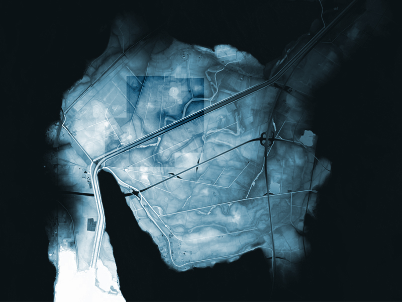
Top Image: Swisstopo Data of the Linth Plain, supplemented and compared with detailed seasonal aerial data: surface model, vegetation, and materialisation (centre).
NL30: The Aerial Gaze: Iterative Aerial Site Scanning for Landscape Analysis, Planning, and Design
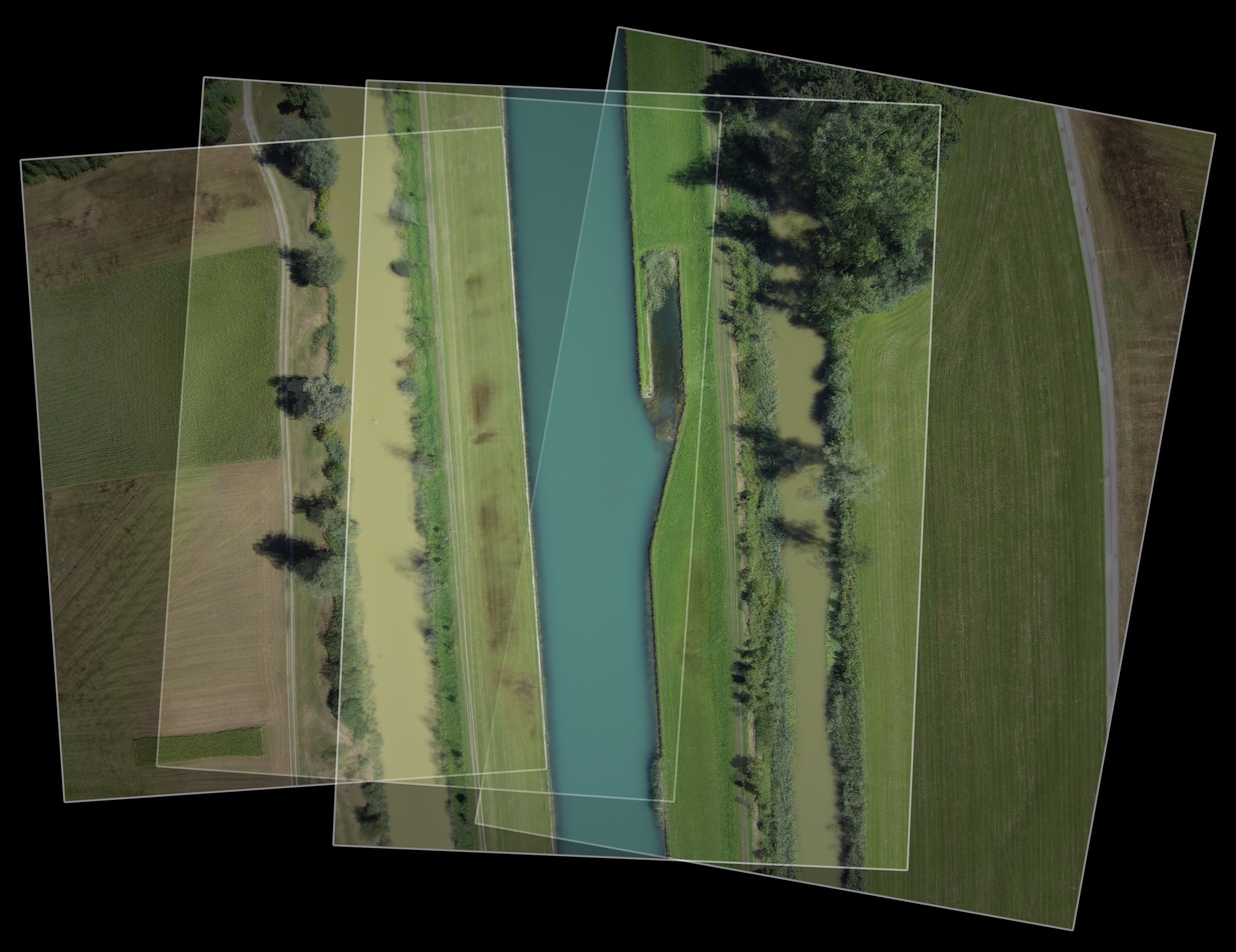
Image: An excerpt of the overlapping aerial images acquired during summer by UAV on the Linth Plain site.
NL30: The Aerial Gaze: Iterative Aerial Site Scanning for Landscape Analysis, Planning, and Design
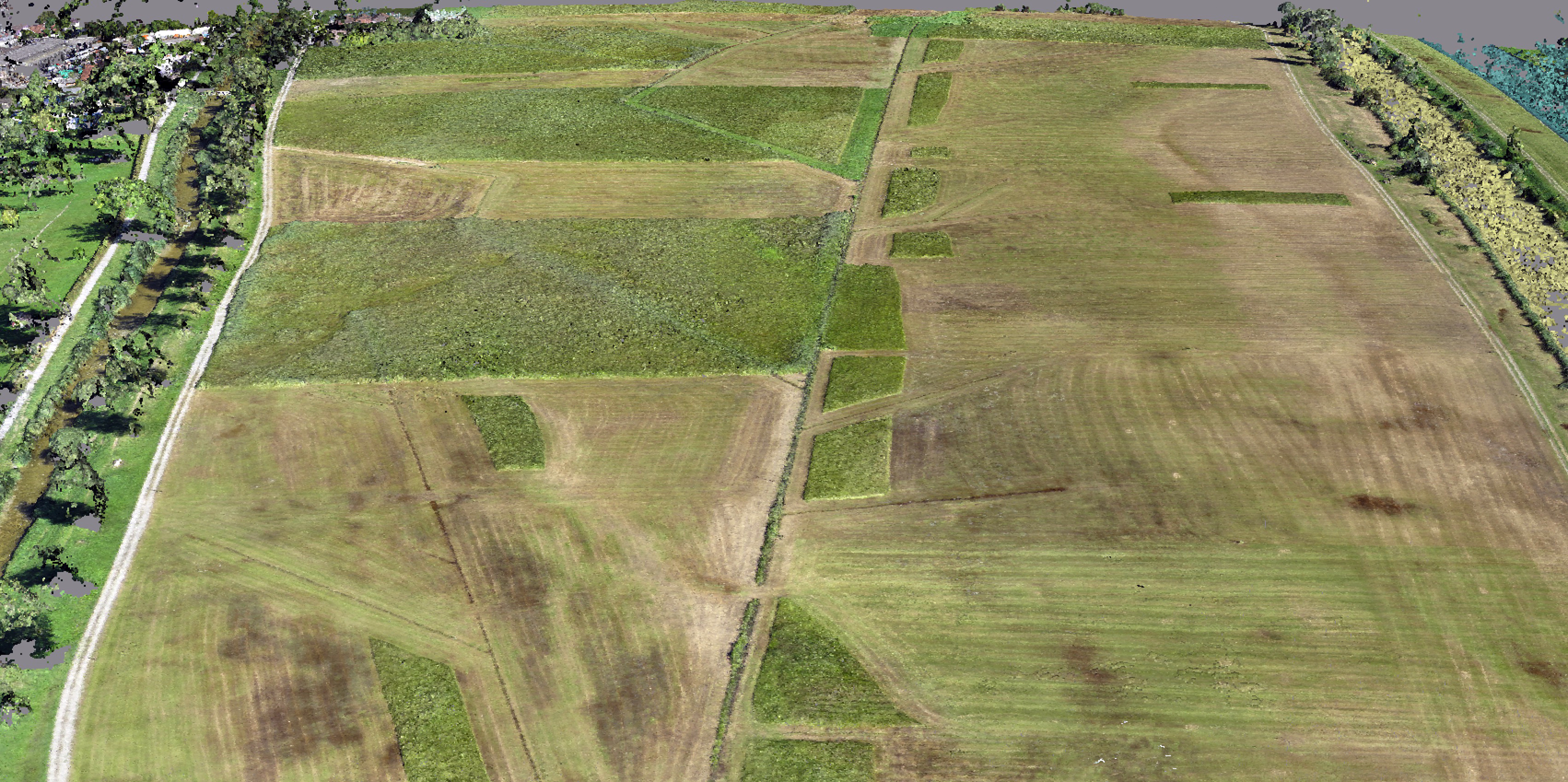
Image: Detail of the 18 million point-cloud resulting from the photogrammetric processing of aerial images along the Linth Canal.
Share on Facebook
Facebook
Tweet about this on Twitter
Twitter
Share on LinkedIn
Linkedin
Email this to someone
email
Questo contributo è stato pubblicato nella seguente newsletter:

30 | Juni 2016: Vogelperspektive

  • Gotthard Landscape – Neue Perspektiven für eine verschollene Landschaft
  • «Wohnforschung wird an Bedeutung noch weiter zunehmen»
  • The Noise Landscape: an Emerging Urban Landscape
  • The Aerial Gaze: Iterative Aerial Site Scanning for Landscape Analysis, Planning, and Design
  • Bad for Traffic: Swiss Drivers Change Lanes too Early in Weaving Areas
  • Modeling Future Urban Scenarios for Switzerland
Kurzmeldungen
  • Ecopotential
Publikationen
  • NEAT – AlpTransit Lötschberg und Gotthard
  • Exploring the choice between in-store and online shopping
  • The Course of Landscape Architecture. A History of our Designs on the Natural World, from Prehistory to the Present
  • Urban Breeding Grounds
  • The effects of on-street parking on the service rate of nearby intersections

Cattedre

Prof. Dr. Bryan T. Adey
Prof. Dr. Kay W. Axhausen
Prof. Dr. Tom Avermaete
Prof. Dr. Francesco Corman
Prof. Teresa Galí-Izard
Prof. Christophe Girot
Prof. Dr. Adrienne Grêt-Regamey
Prof. Dr. Guillaume Habert
Prof. Dr. David Kaufmann
Prof. Hubert Klumpner
Dr. Anastasios Kouvelas
Dr. Markus Nollert
Prof. Freek Persyn
Prof. Dr. Christian Schmid
Prof. Milica Topalovic
EiR PD Dr. Joris Van Wezemael
Prof. Dr. h. c. Günther Vogt
ETH Wohnforum – ETH CASE

Contatto

Indirizzo
ETH Zürich
NSL – Netzwerk Stadt und Landschaft
Stefano-Franscini-Platz 5
HIL H 44.2
8093 Zürich

Direzione NSL
Direttore: Prof. Hubert Klumpner
Vicedirettore: Prof. Dr. David Kaufmann

Ufficio di coordinamento NSL
Claudia Gebert
Telefono: +41 (0)44 633 36 33

Iscriviti alla newsletter della NSL 

Redazione disP

Caporedattrice
Dr. sc. techn. Martina Koll-Schretzenmayr, pianificatrice territoriale ETH/NDS,
Telefono +41 (0)44 633 29 47

Assistente di redazione
Telefono +41 (0)44 633 29 69

Indirizzo
ETH Zürich
Redaktion disP
NSL – Netzwerk Stadt und Landschaft
Stefano-Franscini-Platz 5
HIL H 33.2
8093 Zürich
Fax +41 (0)44 633 12 15
E-Mail

Archivio NSL (gta)

Archivio storico e di ricerca per l’architettura
del paesaggio e la pianificazione ambientale svizzere

Richieste di consultazione

Indirizzo
ETH Zürich
NSL Archive (gta)
Stefano-Franscini-Platz 5
HIL C 65.2
CH-8093 Zurich