NSL – Netzwerk Stadt und Landschaft ETH Zürich
  • Progetti
      • Progetti delle cattedre
        • Prof. Dr. Bryan T. Adey | Gestione delle infrastrutture
        • Prof. Dr. Tom Avermaete | Storia e teoria dell’urbanistica
        • Prof. Dr. Kay W. Axhausen | Pianificazione dei trasporti
        • Prof. Dr. Francesco Corman | Sistemi di trasporto
        • Prof. Teresa Galí-Izard | Chair of Being Alive
        • Prof. Dr. Adrienne Grêt-Regamey | Pianificazione paesaggistica e sistemi urbani
        • Prof. Dr. Eva Heinen | Pianificazione dei trasporti e della mobilità
        • Prof. Dr. David Kaufmann | Sviluppo del territorio e politica urbana
        • Prof. Hubert Klumpner | Architettura e Urbanistica
        • Dr. Anastasios Kouvelas | Ingegneria e controllo del traffico
        • Prof. Dr. Christian Schmid | Sociologia
        • Prof. Milica Topalovic | Architettura e pianificazione territoriale
        • Dr. Jennifer Duyne Barenstein | ETH Wohnforum – ETH CASE
        • NSL-Archiv
      • Ex cattedre
      • Colloqui NSL – Il colloquio NSL è una presentazione semestrale di lavori eccellenti. Il tema viene stabilito di volta in volta dal professore che presenta l’invito.
      • Progetti NSL
          • E-Bike City
          • Future Cities Lab Global
          • Urbane Potentiale und Strategien in metropolitanen Territorien
 – am Beispiel des Metropolitanraums Zürich (NFP65)
          • Large-scale Virtualization and Modeling Lab (LVML)
      • NSL Forum
        • NSL Forum & Cycling Research Board
        • NSL Forum: Pandemie? Mitten im Klimawandel. Was bedeutet das für die räumliche Entwicklung der Schweiz? Ein Dialog.
    Close
  • Insegnamento
    • Insegnamento
        • Bachelor e Master dipartimento ARCH
        • Bachelor e master dipartimento BAUG
        • MSc in Sviluppo territoriale e sistemi infrastrutturali
        • MAS/CAS in Regenerative Materials
        • CAS ETH in Regenerative Systems: dalla sostenibilità alla rigenerazione
        • MAS/CAS Pianificazione del territorio
        • MAS Urban and Territorial Design
        • MAS ETH in edilizia abitativa
        • Doctoral Programme in Landscape and Urban Studies
      • La conoscenza delle forze decisive per lo sviluppo del territorio e la loro interazione, nonché la capacità di sviluppo di strategie risolutive per problematiche territoriali rappresentano i presupposti centrali per lo svolgimento responsabile ed efficace di funzioni di pianificazione al servizio della collettività e di imprese private. Altrettanto importanti sono la formazione, il perfezionamento e l'agggiornamento universitari nel settore della pianificazione territoriale, urbana e del paesaggio. Dal 1965 l'ETH di Zurigo offre corsi di aggiornamento e percorsi di studi post-laurea (NDS, oggi MAS) in questo ambito. I corsi sono gestiti dalla Rete Scientifica Città e Paesaggio (NSL).
    Close
  • Pubblicazioni
    • Cover NL 65Newsletter – NSL riunisce esperti dell’ETH di Zurigo e cura il dialogo con altri ambienti che si occupano o si interessano di questioni relative alla città e al paesaggio.
    • A map describing the different phases of India’s neoliberal highway programme. Source: The author.Pubblicazioni delle cattedre di NSL – Un elenco completo delle pubblicazioni con funzioni di ricerca avanzate è disponibile al seguente link:
      • ETH Zürich Research Collection
    • disP – The Planning Review – La rivista scientifica interdisciplinare tratta temi legati a sviluppo territoriale, urbanistica, pianificazione paesaggistica e ambientale, architettura del paesaggio, economia regionale e ambientale e pianificazione del traffico.
      • Istruzioni per autori / autrici
      • Types of Articles
      • Editore
      • Guida per la stesura di recensioni letterarie
      • Redazione
      • Ultimo numero
      • facebook
    • DELUS Cover Issue 1DELUS – Journal for Landscape and Urban Studies – DELUS è una pubblicazione annuale dell’Istituto di studi urbani e del paesaggio dell’ETH di Zurigo.
    Close
  • Attualità
  • Contatto
      • it
        • de
        • en
        • fr
      • Search

    • Close
      • it
        • de
        • en
        • fr

Thinking Through People: The Potential of Volunteered Geographic Information for Mobility and Urban Studies

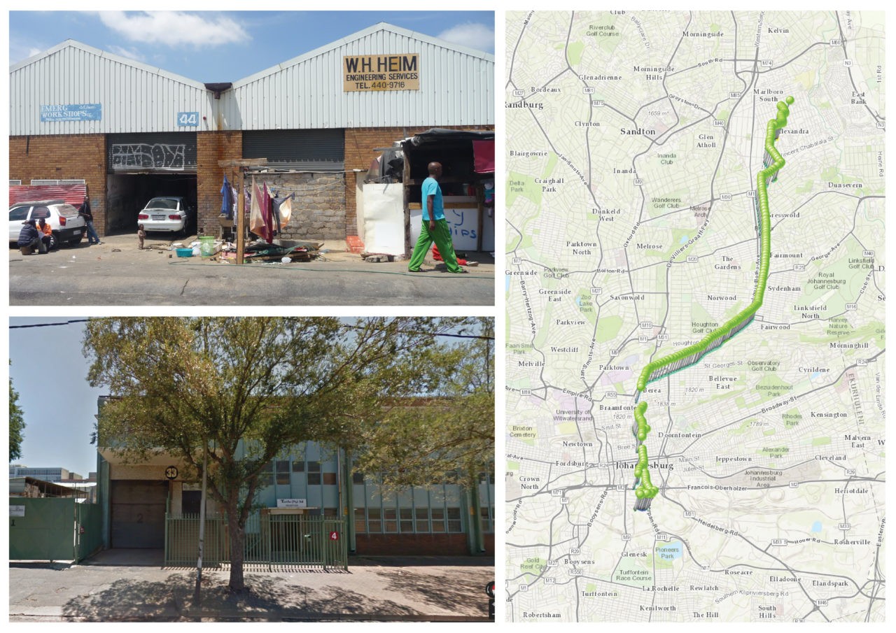
Place of residence in a «residential factory,» pathway to work on a weekday in July, and place of work for study participant «Amusa,» an employed woman in her late thirties (clockwise from top left). © Lindsay Blair Howe, ETH Zurich

Lindsay Blair Howe
2021
Full text

Despite the ‘mobility turn’ in urban studies, there is surprisingly little research into the role people’s everyday movements play in driving urbanisation processes.

As this paper discusses, one reason this has not occurred is because understanding this relationship requires both quantitative and qualitative knowledge, including geospatial locations and patterns as well as why people choose to move the way they do.

Few studies employ mixed methods to this end; instead, many quantitative approaches focus on the use of big data and many qualitative approaches remain focused on sites themselves rather than the movements between them. This methodological gap can preclude operationalising findings and proves particularly detrimental when research is conducted into areas with high levels of poverty and inequality. In response, this paper presents a mixed-methods approach to studying urbanisation, using volunteered geographic information (VGI) to map regional-scale movements in the Gauteng City-Region (GCR). Exploiting the potential of smartphone technology, this methodology operates at the interstice of quantitative and qualitative research, describing both macro-scale mobility patterns and the micro-scale decisions behind them. Using the case study of the GCR, it highlights movement as a strategy for those living in poverty, who can utilise the entire region as a resource to subvert entrenched inequality. ‘Thinking through people’ suggests that a new ontology of categories describing urbanisation processes in terms of movement could connect empirical research into poverty and inequality to theory, and be used to create an epistemology of the urban from below. Thus, this paper contributes to advances in urban studies methods as well as to debates on urbanisation, relational poverty and socio-spatial inequality.
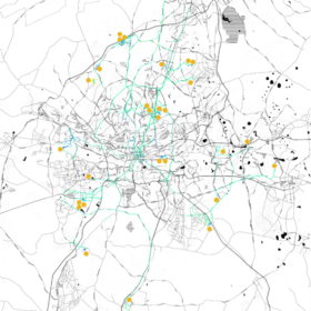
One week mapping the movements of all thirty participants in the first VGI smartphone study in the greater Johannesburg area from 8 July – 14 July 2015. Modes of transportation are indicated by polyline colors; primarily visible are green for vehicular transportation and blue for walking. The home locations of the participants are indicated with orange dots. © Lindsay Blair Howe, ETH Zurich

×
Share this...
  • Facebook
  • Linkedin
  • Whatsapp
  • Email
Questo contributo è stato pubblicato nella seguente newsletter:

52 | Dezember 2021: Risiko / Risk

  • Towards the Unfinished – Dynamic Design for Landscapes at Risk
  • Investing in Water Supply Resilience Considering Future Uncertainty and Management Flexibility
  • Mountain Forest Ecosystem Services at Risk
  • Irrigation Commons: What Lessons for Sustainable Risk Mitigation?
  • «The NSL provides a great platform.»
Kurzmeldungen
  • Gründung upZ (urban publics Zürich)
  • Verkehrs-Pricing im Feldversuch
  • NSL Forum: Pandemie? Mitten im Klimawandel. Was bedeutet das für die räumliche Entwicklung der Schweiz? Ein Dialog.
  • Co-opolis: The Collective Production of the City
  • Urban Transformation Project Sarajevo (UTPS)
Publikationen
  • Thinking Through People: The Potential of Volunteered Geographic Information for Mobility and Urban Studies
  • Robotic Landscapes – Designing the Unfinished
  • Urban Design in the 20th Century: A History
  • Fest, Flüssig, Biotisch. Alpine Landschaften im Wandel
  • Ride Comfort Assessment for Automated Vehicles Utilizing a Road Surface Model and Monte Carlo Simulations
  • disP 57/2, June 2021
Aktuell
  • Urbane Räume: 4 Positionen
  • MAS ETH in Housing
  • Alpine Landschaften im Wandel: Infrastruktur, Kultur und Klima
  • Urbane Transformationen

Cattedre

Prof. Dr. Bryan T. Adey
Prof. Dr. Kay W. Axhausen
Prof. Dr. Tom Avermaete
Prof. Maria Conen
Prof. Dr. Francesco Corman
Dr. Jennifer Duyne Barenstein
Prof. Teresa Galí-Izard
Prof. Dr. Adrienne Grêt-Regamey
Prof. Dr. Guillaume Habert
Prof. Dr. Eva Heinen
Prof. Damian Jerjen
Prof. Dr. David Kaufmann
Prof. Hubert Klumpner
Dr. Anastasios Kouvelas
Prof. Freek Persyn
Prof. Dr. Christian Schmid
Prof. Milica Topalovic
Prof. Martina Voser

Contatto

Indirizzo
ETH Zürich
NSL – Netzwerk Stadt und Landschaft
Stefano-Franscini-Platz 5
HIL H 44.2
8093 Zürich

Direzione NSL
Direttore: Prof. Dr. David Kaufmann
Vicedirettrice: Prof. Milica Topalovic

Ufficio di coordinamento NSL
Claudia Gebert
Telefono: +41 (0)44 633 36 33


Iscriviti alla newsletter della NSL

Redazione disP

Caporedattrice
Dr. sc. techn. Martina Koll-Schretzenmayr, pianificatrice territoriale ETH/NDS,
Telefono +41 (0)44 633 29 47

Indirizzo
ETH Zürich
Redaktion disP
NSL – Netzwerk Stadt und Landschaft
Stefano-Franscini-Platz 5
HIL H 33.3
8093 Zürich
Fax +41 (0)44 633 12 15
E-Mail

Archivio NSL (gta)

Archivio storico e di ricerca per l’architettura
del paesaggio e la pianificazione ambientale svizzere

Richieste di consultazione

Indirizzo
ETH Zürich
NSL Archive (gta)
Stefano-Franscini-Platz 5
HIL C 65.2
CH-8093 Zurich


Protezione dei dati