NSL – Netzwerk Stadt und Landschaft ETH Zürich
  • Projekte
      • Projekte der Professuren
        • Prof. Dr. Bryan T. Adey | Infrastrukturmanagement
        • Prof. Dr. Tom Avermaete | Geschichte und Theorie des Städtebaus
        • Prof. Dr. Kay W. Axhausen | Verkehrsplanung
        • Prof. Dr. Francesco Corman | Verkehrssysteme
        • Prof. Dr. Adrienne Grêt-Regamey | Planung von Landschaft und Urbanen Systemen
        • Prof. Dr. David Kaufmann | Raumentwicklung und Stadtpolitik
        • Prof. Hubert Klumpner | Architektur und Städtebau
        • Dr. Anastasios Kouvelas | Strassenverkehrstechnik
        • Prof. Dr. Christian Schmid | Soziologie
        • Prof. Milica Topalovic | Architektur und Territorialplanung
        • EiR PD Dr. Joris Van Wezemael | Spatial Transformation Laboratories (STL)
        • Prof. em Dr. h. c. Günther Vogt | Landschaftsarchitektur
        • ETH Wohnforum – ETH CASE
        • NSL-Archiv
      • NSL Kolloquienreihe – Präsentation herausragender Arbeit zu einem von der einladenden Professur festgelegten Thema.
      • NSL Projekte
        • Future Cities Lab Global
        • Urbane Potentiale und Strategien in metropolitanen Territorien
 – am Beispiel des Metropolitanraums Zürich (NFP65)
        • Landscape Visualization and Modeling Lab (LVML)
      • NSL Forum: Pandemie? Mitten im Klimawandel. Was bedeutet das für die räumliche Entwicklung der Schweiz? Ein Dialog.
      • Ehemalige Lehrstühle
    Close
  • Lehre
    • Lehrangebote
      • Bachelor- und Masterstudium Departement ARCH
      • Bachelor- und Masterstudium Departement BAUG
      • MSc Raumentwicklung und Infrastruktursysteme
      • MAS/CAS Raumentwicklung
      • MAS Urban and Territorial Design
      • MAS in Housing
      • Doctoral Programme in Landscape and Urban Studies
      • Die Kenntnis der für die räumlichen Entwicklungen massgebenden Kräfte und deren Zusammenwirken wie auch die Fähigkeit zur Entwicklung von Lösungsstrategien für räumliche Problemstellungen sind zentrale Voraussetzungen für verantwortungsvolles und erfolgreiches Ausüben planerischer Funktionen im Dienste öffentlicher Gemeinwesen und privater Unternehmen. Entsprechend bedeutend ist die universitäre Aus-, Weiter- und Fortbildung im Bereich der Raum-, Stadt- und Landschaftsplanung. An der ETH Zürich werden in diesem Bereich seit 1965 Fortbildungs-Kurse und Nachdiplom-Studiengänge (NDS, heute MAS) angeboten. Träger ist das NSL (Netzwerk Stadt und Landschaft).
    Close
  • Publikationen
    • Newsletter – Das NSL führt Fachleute der ETH Zürich zusammen und pflegt den Dialog mit weiteren Kreisen, die sich mit Fragen rund um Stadt und Landschaft befassen oder sich dafür interessieren.
    • Cover der Publikation: Erkenntnisse zum aktuellen WohnungsnotstandAusgewählte Publikationen der NSL–Professuren – Eine vollständige Publikationsliste mit erweiterten Suchfunktionen ist über den folgenden Link zu erreichen:
      • ETH Zürich Research Collection
    • DISP_58/3_CoverdisP – The Planning Review – Die interdisziplinäre wissenschaftliche Zeitschrift behandelt Themen aus den Bereichen Raumentwicklung, Stadtplanung/Städtebau, Landschafts- und Umweltplanung, Landschaftsarchitektur, Regional- und Umweltökonomie sowie Verkehrsplanung.
      • In disP – The Planning Review publizieren
      • Verlag
      • Richtlinien für Buchbesprechungen
      • Redaktion
      • Aktuelle Ausgabe
    Close
  • Aktuell
  • Kontakt
      • de
        • en
        • fr
        • it
      • Search

    • Close

Thinking Through People: The Potential of Volunteered Geographic Information for Mobility and Urban Studies

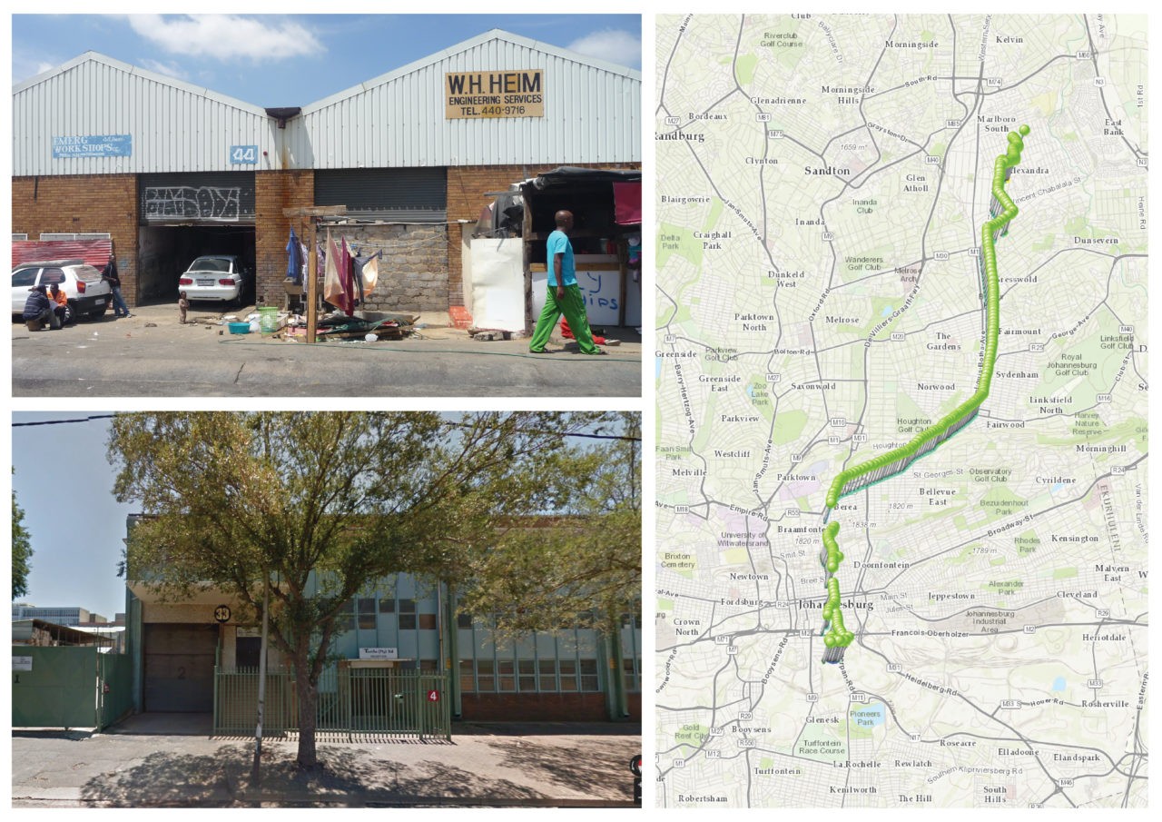
Place of residence in a «residential factory,» pathway to work on a weekday in July, and place of work for study participant «Amusa,» an employed woman in her late thirties (clockwise from top left). © Lindsay Blair Howe, ETH Zurich

Lindsay Blair Howe
2021
Full text

Despite the ‘mobility turn’ in urban studies, there is surprisingly little research into the role people’s everyday movements play in driving urbanisation processes.

As this paper discusses, one reason this has not occurred is because understanding this relationship requires both quantitative and qualitative knowledge, including geospatial locations and patterns as well as why people choose to move the way they do.

Few studies employ mixed methods to this end; instead, many quantitative approaches focus on the use of big data and many qualitative approaches remain focused on sites themselves rather than the movements between them. This methodological gap can preclude operationalising findings and proves particularly detrimental when research is conducted into areas with high levels of poverty and inequality. In response, this paper presents a mixed-methods approach to studying urbanisation, using volunteered geographic information (VGI) to map regional-scale movements in the Gauteng City-Region (GCR). Exploiting the potential of smartphone technology, this methodology operates at the interstice of quantitative and qualitative research, describing both macro-scale mobility patterns and the micro-scale decisions behind them. Using the case study of the GCR, it highlights movement as a strategy for those living in poverty, who can utilise the entire region as a resource to subvert entrenched inequality. ‘Thinking through people’ suggests that a new ontology of categories describing urbanisation processes in terms of movement could connect empirical research into poverty and inequality to theory, and be used to create an epistemology of the urban from below. Thus, this paper contributes to advances in urban studies methods as well as to debates on urbanisation, relational poverty and socio-spatial inequality.
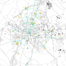
One week mapping the movements of all thirty participants in the first VGI smartphone study in the greater Johannesburg area from 8 July – 14 July 2015. Modes of transportation are indicated by polyline colors; primarily visible are green for vehicular transportation and blue for walking. The home locations of the participants are indicated with orange dots. © Lindsay Blair Howe, ETH Zurich

×
Share this...
  • Facebook
  • Twitter
  • Linkedin
  • Email
Dieser Artikel wurde im folgenden Newsletter publiziert:

52 | Dezember 2021: Risiko / Risk

  • Towards the Unfinished – Dynamic Design for Landscapes at Risk
  • Investing in Water Supply Resilience Considering Future Uncertainty and Management Flexibility
  • Mountain Forest Ecosystem Services at Risk
  • Irrigation Commons: What Lessons for Sustainable Risk Mitigation?
  • «The NSL provides a great platform.»
Kurzmeldungen
  • Gründung upZ (urban publics Zürich)
  • Verkehrs-Pricing im Feldversuch
  • NSL Forum: Pandemie? Mitten im Klimawandel. Was bedeutet das für die räumliche Entwicklung der Schweiz? Ein Dialog.
  • Co-opolis: The Collective Production of the City
  • Urban Transformation Project Sarajevo (UTPS)
Publikationen
  • Thinking Through People: The Potential of Volunteered Geographic Information for Mobility and Urban Studies
  • Robotic Landscapes – Designing the Unfinished
  • Urban Design in the 20th Century: A History
  • Fest, Flüssig, Biotisch. Alpine Landschaften im Wandel
  • Ride Comfort Assessment for Automated Vehicles Utilizing a Road Surface Model and Monte Carlo Simulations
  • disP 57/2, June 2021
Aktuell
  • Urbane Räume: 4 Positionen
  • MAS ETH in Housing
  • Alpine Landschaften im Wandel: Infrastruktur, Kultur und Klima
  • Urbane Transformationen

Professuren

Prof. Dr. Bryan T. Adey
Prof. Dr. Kay W. Axhausen
Prof. Dr. Tom Avermaete
Prof. Maria Conen
Prof. Dr. Francesco Corman
Dr. Jennifer Duyne Barenstein
Prof. Teresa Galí-Izard
Prof. Dr. Adrienne Grêt-Regamey
Prof. Dr. Guillaume Habert
Prof. Dr. David Kaufmann
Prof. Hubert Klumpner
Dr. Anastasios Kouvelas
Prof. Freek Persyn
Prof. Dr. Christian Schmid
Prof. Milica Topalovic
EiR PD Dr. Joris Van Wezemael
Prof. em Dr. h.c. Günther Vogt
ETH Wohnforum – ETH CASE

Kontakt

Adresse
ETH Zürich
NSL – Netzwerk Stadt und Landschaft
Stefano-Franscini-Platz 5
HIL H 44.2
8093 Zürich

Leitung NSL
Leiter: Prof. Hubert Klumpner
Stv. Leiter: Prof. Dr. David Kaufmann

Koordinationsstelle NSL
Claudia Gebert
Telefon: +41 (0)44 633 36 33

Für den NSL Newsletter anmelden

Redaktion disP

Leitende Redaktorin
Dr. sc. techn. Martina Koll-Schretzenmayr, Raumplanerin ETH/NDS,
Telefon +41 (0)44 633 29 47

Redaktionsassistenz
Telefon +41 (0)44 633 29 69

Adresse
ETH Zürich
Redaktion disP
NSL – Netzwerk Stadt und Landschaft
Stefano-Franscini-Platz 5
HIL H 33.2
8093 Zürich
Fax +41 (0)44 633 12 15
E-Mail


NSL Archiv (gta)

Forschungs- und Nachlassarchiv für
Schweizer Landschaftsarchitektur und Raumplanung

Nutzungsanfragen

Adresse
ETH Zürich
NSL Archive (gta)
Stefano-Franscini-Platz 5
HIL C 65.2
CH-8093 Zurich