NSL – Netzwerk Stadt und Landschaft ETH Zürich
  • Progetti
      • Progetti delle cattedre
        • Prof. Dr. Bryan T. Adey | Gestione delle infrastrutture
        • Prof. Dr. Tom Avermaete | Storia e teoria dell’urbanistica
        • Prof. Dr. Kay W. Axhausen | Pianificazione dei trasporti
        • Prof. Dr. Francesco Corman | Sistemi di trasporto
        • Prof. Dr. Adrienne Grêt-Regamey | Pianificazione paesaggistica e sistemi urbani
        • Prof. Dr. David Kaufmann | Sviluppo del territorio e politica urbana
        • Prof. Hubert Klumpner | Architettura e Urbanistica
        • Dr. Anastasios Kouvelas | Ingegneria e controllo del traffico
        • Prof. Dr. Christian Schmid | Sociologia
        • Prof. Milica Topalovic | Architettura e pianificazione territoriale
        • EiR PD Dr. Joris Van Wezemael | Spatial Transformation Laboratories (STL)
        • Prof. em Dr. h. c. Günther Vogt | Architettura del paesaggio
        • ETH Wohnforum – ETH CASE
        • Archivio NSL
      • Colloqui NSL – Il colloquio NSL è una presentazione semestrale di lavori eccellenti. Il tema viene stabilito di volta in volta dal professore che presenta l’invito.
      • Progetti NSL
        • Future Cities Lab Global
        • Urbane Potentiale und Strategien in metropolitanen Territorien
 – am Beispiel des Metropolitanraums Zürich (NFP65)
        • Landscape Visualization and Modeling Lab (LVML)
      • NSL Forum
      • Ex cattedre
    Close
  • Insegnamento
    • Insegnamento
      • Bachelor e Master dipartimento ARCH
      • Bachelor e master dipartimento BAUG
      • MSc in Sviluppo territoriale e sistemi infrastrutturali
      • MAS/CAS Pianificazione del territorio
      • MAS Urban and Territorial Design
      • MAS ETH in edilizia abitativa
      • Doctoral Programme in Landscape and Urban Studies
      • La conoscenza delle forze decisive per lo sviluppo del territorio e la loro interazione, nonché la capacità di sviluppo di strategie risolutive per problematiche territoriali rappresentano i presupposti centrali per lo svolgimento responsabile ed efficace di funzioni di pianificazione al servizio della collettività e di imprese private. Altrettanto importanti sono la formazione, il perfezionamento e l'agggiornamento universitari nel settore della pianificazione territoriale, urbana e del paesaggio. Dal 1965 l'ETH di Zurigo offre corsi di aggiornamento e percorsi di studi post-laurea (NDS, oggi MAS) in questo ambito. I corsi sono gestiti dalla Rete Scientifica Città e Paesaggio (NSL).
    Close
  • Pubblicazioni
    • Newsletter – NSL riunisce esperti dell’ETH di Zurigo e cura il dialogo con altri ambienti che si occupano o si interessano di questioni relative alla città e al paesaggio.
    • Pubblicazioni delle cattedre di NSL – Un elenco completo delle pubblicazioni con funzioni di ricerca avanzate è disponibile al seguente link:
      • ETH Zürich Research Collection
    • DISP_58/3_CoverdisP – The Planning Review – La rivista scientifica interdisciplinare tratta temi legati a sviluppo territoriale, urbanistica, pianificazione paesaggistica e ambientale, architettura del paesaggio, economia regionale e ambientale e pianificazione del traffico.
      • Pubblicare su disP – The Planning Review
      • Editore
      • Guida per la stesura di recensioni letterarie
      • Redazione
      • Ultimo numero
      • facebook
    Close
  • Attualità
  • Contatto
      • it
        • de
        • en
        • fr
      • Search

    • Close

Visualization as Experimentation

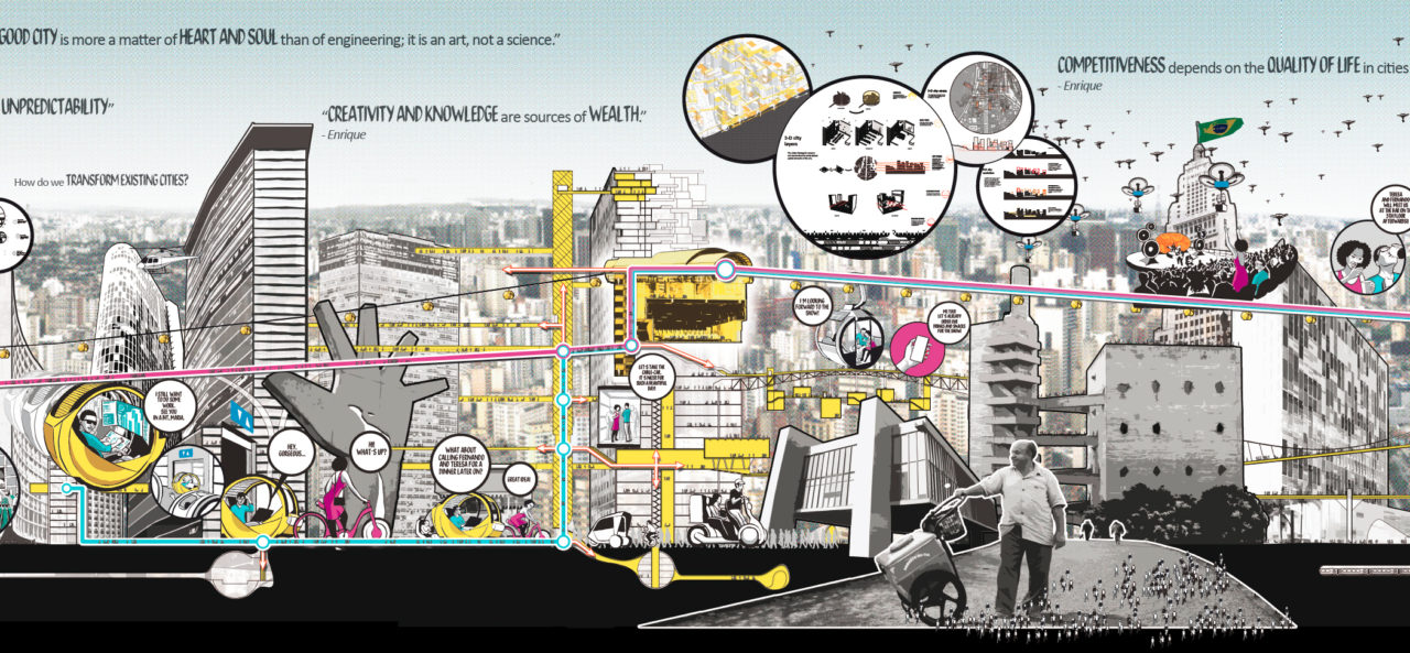
«As a creative practice, mapping precipitates its most productive effects through a finding that is also a founding; its agency lies in neither reproduction nor imposition but rather in uncovering realities previously unseen or unimagined, even across seemingly exhausted grounds. Thus, mapping ‘unfolds’ potential; it re-makes territory over and over again, each time with new and diverse consequences.»

Visualization is a dynamic action, not a static product, and it is through this action that we can develop new understandings of place and alternative models of social design. Beyond the conventional role of representing a final design image, visualization plays the far more important role of allowing us to construct alternative urban futures of process-based design – through critical mapping and communicating ideas.

A critical mapping does not simply redraw what exists – it is not a survey – instead a critical mapping must read, interpret and represent the visible and invisible challenges and potentials on site. Mapping is an extremely creative process that blends empirical data with aesthetic imagery, fact with fiction, reality with imagination. It is a process that builds knowledge in order to create a deeper understanding of place.

Likewise, project drawings are more than simple representations of proposals – they are products of the rigorous process of design through making. Designers must invent, develop, and improve innovative modes of representation that can effectively and provocatively communicate ideas beyond conventional models. Representation should achieve more than the arrangement of elements or components – it is a tool to explore the possibilities of visual communication and the dynamics of design.

Visualization is experimentation, a necessary tool that can bridge design and public action.

Citation: James Corner

Michael Contento & Lindsey Sherman

NL20: Visualization as Experimentation
Metro Cable, La Ceiba Station
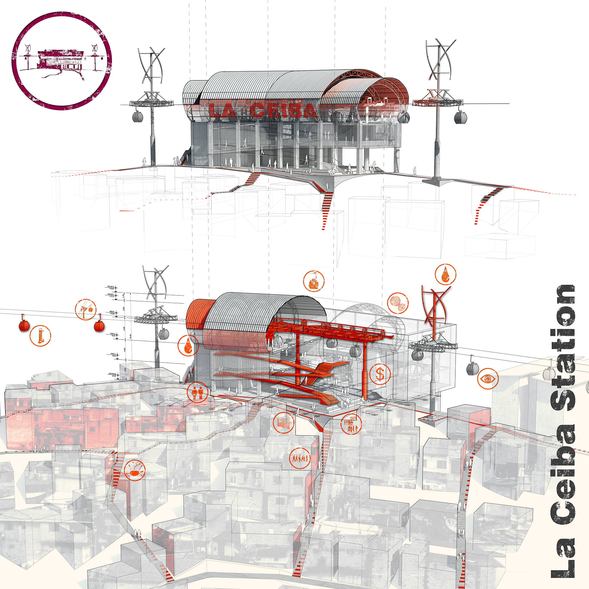
Each station consists of a number of catalysts that provide layers of social infrastructure and public space in addition to mobility infrastructure. Caracas, Venezuela. By: Urban-Think Tank
Share this...
  • Facebook
  • Twitter
  • Linkedin
  • Email
Questo contributo è stato pubblicato nella seguente newsletter:

20 | Dezember 2013: Visualisierungen

  • «Digital Landscape Architecture» Konferenz an der ETH Zürich: DLA 2014
  • Visualization as Experimentation
  • Video, Audio, Moveo: sinnlich erweiterter Landschaftsraum
  • Sind Politikmassnahmen oder das Landschaftsbild wichtiger für Entscheidungen zur partizipativen Landschaftsentwicklung?
Kurzmeldungen
  • Effect of Resource Endowments and Limited State Capacity on Political Conflict
  • VisAsim: Visuell‐Akustische Simulation zur Bewertung der Landschaftsverträglichkeit von Windparks
  • Visualisierung Gewässerraum
Publikationen
  • Topical Thoughts on the Contemporary Landscape
  • Methodik zur Effizienzbeurteilung der Kapazitätsnutzung und -entwicklung von Bahnnetzen
  • Grossräumige Evakuierung – Agenten-basierte Analyse
  • Methodology to Evaluate Cost and Accuracy of Parking Patrol Surveys
  • The School, The Book, The Town. Logbook – Ethiopia in a Timeline

Cattedre

Prof. Dr. Bryan T. Adey
Prof. Dr. Kay W. Axhausen
Prof. Dr. Tom Avermaete
Prof. Maria Conen
Prof. Dr. Francesco Corman
Dr. Jennifer Duyne Barenstein
Prof. Teresa Galí-Izard
Prof. Dr. Adrienne Grêt-Regamey
Prof. Dr. Guillaume Habert
Prof. Dr. David Kaufmann
Prof. Hubert Klumpner
Dr. Anastasios Kouvelas
Prof. Freek Persyn
Prof. Dr. Christian Schmid
Prof. Milica Topalovic
EiR PD Dr. Joris Van Wezemael
Prof. em Dr. h. c. Günther Vogt
ETH Wohnforum – ETH CASE

Contatto

Indirizzo
ETH Zürich
NSL – Netzwerk Stadt und Landschaft
Stefano-Franscini-Platz 5
HIL H 44.2
8093 Zürich

Direzione NSL
Direttore: Prof. Hubert Klumpner
Vicedirettore: Prof. Dr. David Kaufmann

Ufficio di coordinamento NSL
Claudia Gebert
Telefono: +41 (0)44 633 36 33

Iscriviti alla newsletter della NSL

Redazione disP

Caporedattrice
Dr. sc. techn. Martina Koll-Schretzenmayr, pianificatrice territoriale ETH/NDS,
Telefono +41 (0)44 633 29 47

Assistente di redazione
Telefono +41 (0)44 633 29 69

Indirizzo
ETH Zürich
Redaktion disP
NSL – Netzwerk Stadt und Landschaft
Stefano-Franscini-Platz 5
HIL H 33.2
8093 Zürich
Fax +41 (0)44 633 12 15
E-Mail

Archivio NSL (gta)

Archivio storico e di ricerca per l’architettura
del paesaggio e la pianificazione ambientale svizzere

Richieste di consultazione

Indirizzo
ETH Zürich
NSL Archive (gta)
Stefano-Franscini-Platz 5
HIL C 65.2
CH-8093 Zurich