NSL – Netzwerk Stadt und Landschaft ETH Zürich
  • Progetti
      • Progetti delle cattedre
        • Prof. Dr. Bryan T. Adey | Gestione delle infrastrutture
        • Prof. Dr. Tom Avermaete | Storia e teoria dell’urbanistica
        • Prof. Dr. Kay W. Axhausen | Pianificazione dei trasporti
        • Prof. Dr. Francesco Corman | Sistemi di trasporto
        • Prof. Teresa Galí-Izard | Chair of Being Alive
        • Prof. Dr. Adrienne Grêt-Regamey | Pianificazione paesaggistica e sistemi urbani
        • Prof. Dr. Eva Heinen | Pianificazione dei trasporti e della mobilità
        • Prof. Dr. David Kaufmann | Sviluppo del territorio e politica urbana
        • Prof. Hubert Klumpner | Architettura e Urbanistica
        • Dr. Anastasios Kouvelas | Ingegneria e controllo del traffico
        • Prof. Dr. Christian Schmid | Sociologia
        • Prof. Milica Topalovic | Architettura e pianificazione territoriale
        • Dr. Jennifer Duyne Barenstein | ETH Wohnforum – ETH CASE
        • NSL-Archiv
      • Ex cattedre
      • Colloqui NSL – Il colloquio NSL è una presentazione semestrale di lavori eccellenti. Il tema viene stabilito di volta in volta dal professore che presenta l’invito.
      • Progetti NSL
          • E-Bike City
          • Future Cities Lab Global
          • Urbane Potentiale und Strategien in metropolitanen Territorien
 – am Beispiel des Metropolitanraums Zürich (NFP65)
          • Large-scale Virtualization and Modeling Lab (LVML)
      • NSL Forum
        • NSL Forum & Cycling Research Board
        • NSL Forum: Pandemie? Mitten im Klimawandel. Was bedeutet das für die räumliche Entwicklung der Schweiz? Ein Dialog.
    Close
  • Insegnamento
    • Insegnamento
        • Bachelor e Master dipartimento ARCH
        • Bachelor e master dipartimento BAUG
        • MSc in Sviluppo territoriale e sistemi infrastrutturali
        • MAS/CAS in Regenerative Materials
        • CAS ETH in Regenerative Systems: dalla sostenibilità alla rigenerazione
        • MAS/CAS Pianificazione del territorio
        • MAS Urban and Territorial Design
        • MAS ETH in edilizia abitativa
        • Doctoral Programme in Landscape and Urban Studies
      • La conoscenza delle forze decisive per lo sviluppo del territorio e la loro interazione, nonché la capacità di sviluppo di strategie risolutive per problematiche territoriali rappresentano i presupposti centrali per lo svolgimento responsabile ed efficace di funzioni di pianificazione al servizio della collettività e di imprese private. Altrettanto importanti sono la formazione, il perfezionamento e l'agggiornamento universitari nel settore della pianificazione territoriale, urbana e del paesaggio. Dal 1965 l'ETH di Zurigo offre corsi di aggiornamento e percorsi di studi post-laurea (NDS, oggi MAS) in questo ambito. I corsi sono gestiti dalla Rete Scientifica Città e Paesaggio (NSL).
    Close
  • Pubblicazioni
    • Cover NL 65Newsletter – NSL riunisce esperti dell’ETH di Zurigo e cura il dialogo con altri ambienti che si occupano o si interessano di questioni relative alla città e al paesaggio.
    • A map describing the different phases of India’s neoliberal highway programme. Source: The author.Pubblicazioni delle cattedre di NSL – Un elenco completo delle pubblicazioni con funzioni di ricerca avanzate è disponibile al seguente link:
      • ETH Zürich Research Collection
    • disP – The Planning Review – La rivista scientifica interdisciplinare tratta temi legati a sviluppo territoriale, urbanistica, pianificazione paesaggistica e ambientale, architettura del paesaggio, economia regionale e ambientale e pianificazione del traffico.
      • Istruzioni per autori / autrici
      • Types of Articles
      • Editore
      • Guida per la stesura di recensioni letterarie
      • Redazione
      • Ultimo numero
      • facebook
    • DELUS Cover Issue 1DELUS – Journal for Landscape and Urban Studies – DELUS è una pubblicazione annuale dell’Istituto di studi urbani e del paesaggio dell’ETH di Zurigo.
    Close
  • Attualità
  • Contatto
      • it
        • de
        • en
        • fr
      • Search

    • Close
      • it
        • de
        • en
        • fr

When the Dog is Dead, Throw it in the River – Mapping and the Challenges of the Ciliwung

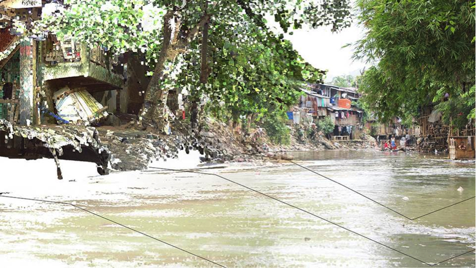
Urban rivers facing pressure from rapid urbanisation often take on multiple roles beyond their natural ecological function. The Ciliwung River flows through the megacity of Jakarta and is located in West Java, Indonesia. Along with many rivers in Southeast Asia it has become an environmental buffer to Jakarta’s poorly managed waste. A popular Javanese jingle from the 1990’s includes the phrase: «…when the dog is dead, throw it in the river», and serves to illustrate some of the complex cultural factors behind the long-compromised role of Indonesia’s rivers.

The Future Cities Laboratory’s (FCL) Landscape Ecology team has been researching the Ciliwung River since 2011. The cumulative research efforts within this challenging context often required the use of unconventional methods to obtain what is generally considered base knowledge. A variety of simulations and design scenarios have been produced as a result of the work.

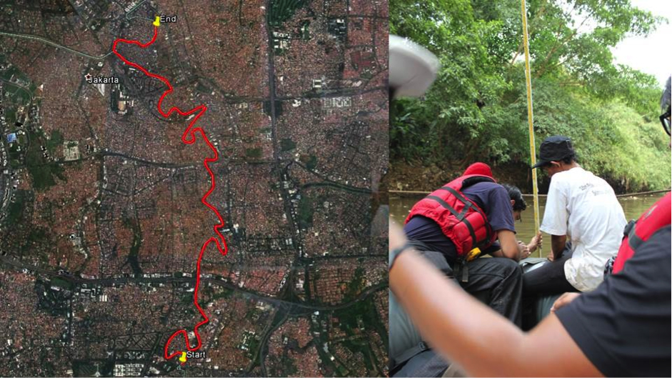
In October 2013 four members of the FCL’s Landscape Ecology team travelled the Ciliwung River by boat. The objective of the journey was to ground-truth bathymetric information along the river against official measurements which were provided by local ministries. This field checking was essential to constructing a digital model of the river, and required documenting its physical attributes including the depth and width of key cross-sections using spatially referenced measurements.

A series of collaborations with community groups were essential to the success of the expedition, as they provided necessary local knowledge and were more resilient to unexpected events that befell the team. For example, a garbage blockage meant that the boat itself needed to be lifted out of the river and carried some 50-meters overland before the expedition could continue. Meanwhile, an initial attempt to measure the depths of the river was thwarted by the strength of the current, which destroyed some equipment and meant that the measurement tools also had to adapt.

This anecdotal attempt to map the Ciliwung River provided a foundational understanding and context to the physical attributes of the site. The information sourced during the mapping exercise has since been valuable in the material investigation of specific site elements. Thus these new methods of mapping, a result of the collaboration between locals and researchers, have been  essential in furthering the team’s work on the Ciliwung River.

Results

The work was presented in a conference and exhibition in Jakarta, in November 2014, and was recently exhibited at Singapore’s Urban Redevelopment Authority in ‘Future Cities: Research in Action’, from January to March 2015. It is also scheduled to be included in the Shenzhen Biennale at the end of the year. The research of the Landscape Ecology team will be compiled in a series of journal articles and published as a Special Issue in the journal of Sustainable Cities and Society titled ‘Rehabilitating urban rivers: merging science with design’. 

Expedition Team

Ervine Lin, Yazid Ninsalam, Michaela F. Prescott, Federica Remondi, Kashif Shaad 

Principal Investigators, Research Module Landscape Ecology 

Prof. Christophe Girot (PI), Prof. Dr. Paolo Burlando (Co PI), Prof. Dr. Adrienne Grêt-Regamey (Co PI), Associate Prof. Dr. Jörg Rekittke (NUS) and Prof. Dr. Liong Shie Yui (NUS) 

Researchers

Dr. Senthil Gurusamy, Dr. Rita Padawangi, Diogo Costa, Ervine Lin, Yazid Ninsalam, Michaela F. Prescott, Federica Remondi, Kashif Shaad, Derek Vollmer 

Community Group

Relawan Peduli Ciliwung   

NL25: When the Dog is Dead, Throw it in the River – Mapping and the Challenges of the Ciliwung
Map illustrating the 12-kilometers travelled along the Ciliwung River from Condet to Kampung Melayu (left side). A researcher and a member of a community group working together to take a depth measurement (right side). Source: Federica Remondi
Share this...
  • Facebook
  • Linkedin
  • Whatsapp
  • Email
Questo contributo è stato pubblicato nella seguente newsletter:

25 | März 2015: Mapping

  • Mapping Everything
  • «Explorative Data-Mapping – Experimental Teaching Tools» innerhalb des MAS in Landscape Architecture
  • Verkehrsinfrastruktur, Macht, Staat
  • Geographies of Opportunity
  • When the Dog is Dead, Throw it in the River – Mapping and the Challenges of the Ciliwung
Kurzmeldungen
  • Workshops zur Kartierung von Ökosystemleistungen
  • Improving Pedestrian Mobility Through Bottom-Up Strategies, ETH-EiABC Workshop 2014 Addis Ababa Ethiopia
  • NSM – Advancing the Model for Safety Improvement of the Road Network in the City of Zurich
  • Effiziente Flughafenerschliessungssysteme im Hinblick auf die Landnutzung an Flughäfen
  • Neue Studienleitung des MAS, CAS, DAS Raumplanung
  • Teilnehmende für Eye-Tracking-Studie gesucht
Publikationen
  • Young-Old: Urban Utopias of an Aging Society.
  • From absolute protection to controlled disaster: New perspectives on flood management in times of climate change
  • Analysis of the Network Exit Functions for different urban grid network configurations
  • Forget About Utopia
  • Integrated Transport and Land Use Modeling for Sustainable Cities
  • How international borders affect local public transport: Analyses and evaluations of cross-border agglomerations in Switzerland. France and Germany

Cattedre

Prof. Dr. Bryan T. Adey
Prof. Dr. Kay W. Axhausen
Prof. Dr. Tom Avermaete
Prof. Maria Conen
Prof. Dr. Francesco Corman
Dr. Jennifer Duyne Barenstein
Prof. Teresa Galí-Izard
Prof. Dr. Adrienne Grêt-Regamey
Prof. Dr. Guillaume Habert
Prof. Dr. Eva Heinen
Prof. Damian Jerjen
Prof. Dr. David Kaufmann
Prof. Hubert Klumpner
Dr. Anastasios Kouvelas
Prof. Freek Persyn
Prof. Dr. Christian Schmid
Prof. Milica Topalovic
Prof. Martina Voser

Contatto

Indirizzo
ETH Zürich
NSL – Netzwerk Stadt und Landschaft
Stefano-Franscini-Platz 5
HIL H 44.2
8093 Zürich

Direzione NSL
Direttore: Prof. Dr. David Kaufmann
Vicedirettrice: Prof. Milica Topalovic

Ufficio di coordinamento NSL
Claudia Gebert
Telefono: +41 (0)44 633 36 33


Iscriviti alla newsletter della NSL

Redazione disP

Caporedattrice
Dr. sc. techn. Martina Koll-Schretzenmayr, pianificatrice territoriale ETH/NDS,
Telefono +41 (0)44 633 29 47

Indirizzo
ETH Zürich
Redaktion disP
NSL – Netzwerk Stadt und Landschaft
Stefano-Franscini-Platz 5
HIL H 33.3
8093 Zürich
Fax +41 (0)44 633 12 15
E-Mail

Archivio NSL (gta)

Archivio storico e di ricerca per l’architettura
del paesaggio e la pianificazione ambientale svizzere

Richieste di consultazione

Indirizzo
ETH Zürich
NSL Archive (gta)
Stefano-Franscini-Platz 5
HIL C 65.2
CH-8093 Zurich


Protezione dei dati