NSL – Netzwerk Stadt und Landschaft ETH Zürich
  • Projekte
      • Projekte der Professuren
        • Prof. Dr. Bryan T. Adey | Infrastrukturmanagement
        • Prof. Dr. Tom Avermaete | Geschichte und Theorie des Städtebaus
        • Prof. Dr. Kay W. Axhausen | Verkehrsplanung
        • Prof. Dr. Francesco Corman | Verkehrssysteme
        • Prof. Teresa Galí-Izard | Professur Being Alive
        • Prof. Dr. Adrienne Grêt-Regamey | Planung von Landschaft und Urbanen Systemen
        • Prof. Dr. Eva Heinen | Verkehrs- und Mobilitätsplanung
        • Prof. Dr. David Kaufmann | Raumentwicklung und Stadtpolitik
        • Prof. Hubert Klumpner | Architektur und Städtebau
        • Dr. Anastasios Kouvelas | Strassenverkehrstechnik
        • Prof. Dr. Christian Schmid | Soziologie
        • Prof. Milica Topalovic | Architektur und Territorialplanung
        • Dr. Jennifer Duyne Barenstein | ETH Wohnforum – ETH CASE
        • NSL-Archiv
      • Ehemalige Professuren
      • NSL Kolloquienreihe – Präsentation herausragender Arbeit zu einem von der einladenden Professur festgelegten Thema.
      • NSL Projekte
          • E-Bike City
          • Future Cities Lab Global
          • Urbane Potentiale und Strategien in metropolitanen Territorien
 – am Beispiel des Metropolitanraums Zürich (NFP65)
          • Large-scale Virtualization and Modeling Lab (LVML)
      • NSL Foren
        • NSL Forum & Cycling Research Board
        • NSL Forum: Pandemie? Mitten im Klimawandel. Was bedeutet das für die räumliche Entwicklung der Schweiz? Ein Dialog.
    Close
  • Lehre
    • Lehrangebote
      • Bachelor- und Masterstudium Departement ARCH
      • Bachelor- und Masterstudium Departement BAUG
      • MSc Raumentwicklung und Infrastruktursysteme
      • MAS/CAS in Regenerative Materials
      • CAS in Regenerative Systems: Sustainability to Regeneration
      • MAS/CAS Raumentwicklung
      • MAS Urban and Territorial Design
      • MAS in Housing
      • Doctoral Programme in Landscape and Urban Studies
      • Die Kenntnis der für die räumlichen Entwicklungen massgebenden Kräfte und deren Zusammenwirken wie auch die Fähigkeit zur Entwicklung von Lösungsstrategien für räumliche Problemstellungen sind zentrale Voraussetzungen für verantwortungsvolles und erfolgreiches Ausüben planerischer Funktionen im Dienste öffentlicher Gemeinwesen und privater Unternehmen. Entsprechend bedeutend ist die universitäre Aus-, Weiter- und Fortbildung im Bereich der Raum-, Stadt- und Landschaftsplanung. An der ETH Zürich werden in diesem Bereich seit 1965 Fortbildungs-Kurse und Nachdiplom-Studiengänge (NDS, heute MAS) angeboten. Träger ist das NSL (Netzwerk Stadt und Landschaft).
    Close
  • Publikationen
    • Cover NL 65Newsletter – Das NSL führt Fachleute der ETH Zürich zusammen und pflegt den Dialog mit weiteren Kreisen, die sich mit Fragen rund um Stadt und Landschaft befassen oder sich dafür interessieren.
    • A map describing the different phases of India’s neoliberal highway programme. Source: The author.Ausgewählte Publikationen der NSL–Professuren – Eine vollständige Publikationsliste mit erweiterten Suchfunktionen ist über den folgenden Link zu erreichen:
      • ETH Zürich Research Collection
    • disP – The Planning Review – Die interdisziplinäre wissenschaftliche Zeitschrift behandelt Themen aus den Bereichen Raumentwicklung, Stadtplanung/Städtebau, Landschafts- und Umweltplanung, Landschaftsarchitektur, Regional- und Umweltökonomie sowie Verkehrsplanung.
      • Angaben für Autor:innen
      • Types of Articles
      • Verlag
      • Richtlinien für Buchbesprechungen
      • Redaktion
      • Aktuelle Ausgabe
    • DELUS Cover Issue 1DELUS – Journal for Landscape and Urban Studies – DELUS ist eine jährliche Publikation des Instituts für Stadt- und Landschaftsforschung der ETH Zürich
    Close
  • Aktuell
  • Kontakt
      • de
        • en
        • fr
        • it
      • Search

    • Close
      • de
        • en
        • fr
        • it

Settlement Relationships and their Morphological Homogeneity Across Time and Scale

Example of the settlement network evolution between 1899 and 2020. This depiction shows the same area in the north-east of the study area, between Winterthur (ZH) and St. Gallen (SG), at two different time steps. The settlement links represent pairs of settlements that are reachable within 10 min of travel time (tt). The size of the settlements has changed over time, as they have sprawled and merged with one another. Hill-shade map source: ESRI, CGIAR, and USGS

Yves M. Räth, Adrienne Grêt-Regamey, Chenjing Jiao, Sidi Wu, Maarten J. van Strien
2023
Full text

Homogeneous settlement morphologies negatively impact urban vibrancy, the environment, and emotions. Mainly resulting from the separation of functions such as work and living, homogeneous settlements have often been found around large cities.

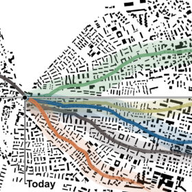
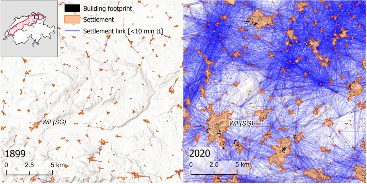
However, it remains unknown whether this phenomenon occurs in settlements of any size and persisted over time. In this study, we investigated the relationship between the internal structures of settlements and their location within a settlement network at a large spatial scale and a fine resolution, over seven time steps covering 120 years of settlement development. Using building footprints and road geometries from historical maps of the Swiss Plateau in combination with historical travel speeds, we analyzed networks at both the local- (building networks) and the regional-scale (settlement networks). Our findings show that particularly small settlements located near larger settlements exhibit a high degree of morphological homogeneity, and that this pattern persisted since the early twentieth century despite strong changes in mobility. These results suggest that the position of a settlement within a settlement network can have an impact on its morphological homogeneity, which in turn can have consequences for the functionality and livability of the settlement and provides useful insight to the development of settlements.

Lesen Sie auch

Beispiel für die Zeitreihe des Verkehrsvolumens auf ländlichen Strassen (rote Linien) in der Region um die Stadt Peking in China. Das Jahr für jeden Zeitschritt steht unterhalb der Abbildung. Die Breite des Strassenabschnitts ist proportional zum Verkehrsvolumen auf der Strasse. Die Ausdehnung des Stadtgebiets ist in Dunkelrot dargestellt. Es ist deutlich zu erkennen, dass der Strassenverkehr im ländlichen Gebiet dieser Region zwischen 1975 und 2015 stark zugenommen hat. © ETH Zürich

Globale Modellierung des ländlichen Strassenverkehrs ausserhalb der Städte
» Newsletter-Artikel

Conceptualisation of Urban Development Pathways: Navigating Towards Resilient and Adaptive Urban Landscapes © ETH Zürich

Escape Determinism – Unlocking Desirable Urban Development Pathways
» Newsletter-Artikel

×
Share this...
  • Facebook
  • Linkedin
  • Whatsapp
  • Email
Dieser Artikel wurde im folgenden Newsletter publiziert:

60 | Dezember 2023: Resiliente Urbane Systeme / Resilient Urban Systems

  • Wie verändert sich das Verkehrsgleichgewicht durch Home office?
  • City of Codes
  • Adaptive Urban Planning for an Uncertain Future: Infrastructure Interventions for the Technological Shift in Transportation
  • Antifragile Urban Mobility: Traffic Control Beyond Resilience
  • Zwischen Wolkenkratzern und Zustimmung? Über Akzeptanz für urbane Verdichtung aus raumplanerischer Perspektive
  • Escape Determinism – Unlocking Desirable Urban Development Pathways
  • Verfechter des öffentlichen Raums
Kurzmeldungen
  • NSL Colloquium Planetary Urbanisation: Video now Online!
  • Prof. Maria Conen und Prof. Dr. Elli Mosayebi erneuern das Direktorium des ETH Wohnforum
  • Community-led Landscape Restoration 2024: Call for Applications
  • Martina Voser zur ordentlichen Professorin für Landschaftsarchitektur ernannt
  • Prof. Dr. Eva Heinen zur ordentlichen Professorin für Verkehrs-​ und Mobilitätsplanung ernannt
Publikationen
  • Vocabularies for an Urbanising Planet: Theory Building through Comparison NOW OPEN ACCESS DOWNLOAD
  • Extended Urbanisation. Tracing Planetary Struggles NOW OPEN ACCESS DOWNLOAD!
  • Settlement Relationships and their Morphological Homogeneity Across Time and Scale
  • Listening In: Conversations on Architectures, Cities and Landscapes, 1700-1900 – Programme and Abstracts
  • disP 59/2, June 2023
Weiterbildung / Studiengänge
  • EPFL ETH MAS Urban and Territorial Design
  • MAS ETH in Housing
Aktuell
  • LUS Doctoral Crits
  • Planetary Urbanisation – Aufruf zur Tat | Agrifutures Zürich – Agrarökologisches Gestalten
  • Reflective Practitioners

Professuren

Prof. Dr. Bryan T. Adey
Prof. Dr. Kay W. Axhausen
Prof. Dr. Tom Avermaete
Prof. Maria Conen
Prof. Dr. Francesco Corman
Dr. Jennifer Duyne Barenstein
Prof. Teresa Galí-Izard
Prof. Dr. Adrienne Grêt-Regamey
Prof. Dr. Guillaume Habert
Prof. Dr. Eva Heinen
Prof. Damian Jerjen
Prof. Dr. David Kaufmann
Prof. Hubert Klumpner
Dr. Anastasios Kouvelas
Prof. Freek Persyn
Prof. Dr. Christian Schmid
Prof. Milica Topalovic
Prof. Martina Voser

Kontakt

Adresse
ETH Zürich
NSL – Netzwerk Stadt und Landschaft
Stefano-Franscini-Platz 5
HIL H 44.2
8093 Zürich

Leitung NSL
Leiter: Prof. Dr. David Kaufmann
Stv. Leiterin: Prof. Milica Topalovic

Koordinationsstelle NSL
Claudia Gebert
Telefon: +41 (0)44 633 36 33


Für den NSL Newsletter anmelden

Redaktion disP

Leitende Redaktorin
Dr. sc. techn. Martina Koll-Schretzenmayr, Raumplanerin ETH/NDS,
Telefon +41 (0)44 633 29 47

Adresse
ETH Zürich
Redaktion disP
NSL – Netzwerk Stadt und Landschaft
Stefano-Franscini-Platz 5
HIL H 33.3
8093 Zürich
Fax +41 (0)44 633 12 15
E-Mail


NSL Archiv (gta)

Forschungs- und Nachlassarchiv für
Schweizer Landschaftsarchitektur und Raumplanung

Nutzungsanfragen

Adresse
ETH Zürich
NSL Archive (gta)
Stefano-Franscini-Platz 5
HIL C 65.2
CH-8093 Zurich


Datenschutz (Privacy Policy)