NSL – Netzwerk Stadt und Landschaft ETH Zürich
  • Projects
      • Projects of the Chairs
        • Prof. Dr. Bryan T. Adey | Infrastructure Management
        • Prof. Dr. Tom Avermaete | History and Theory of Urban Design
        • Prof. Dr. Kay W. Axhausen | Traffic and Transport Planning
        • Prof. Dr. Francesco Corman | Transport Systems
        • Prof. Dr. Adrienne Grêt-Regamey | Planning of Landscape and Urban Systems (PLUS)
        • Prof. Dr. David Kaufmann | Spatial Development and Urban Policy
        • Prof. Hubert Klumpner | Architecture and Urban Design
        • Dr. Anastasios Kouvelas | Traffic Engineering and Control
        • Prof. Dr. Christian Schmid | Sociology
        • Prof. Milica Topalovic | Architecture and Territorial Planning
        • EiR PD Dr. Joris Van Wezemael | Spatial Transformation Laboratories (STL)
        • Prof. em Dr. h. c. Günther Vogt | Landscape Architecture
        • ETH Wohnforum – ETH CASE
        • NSL Archive
      • NSL Colloquia – The NSL Colloquia are a bi-annual presentation of exceptional work under a rotating theme determined by the inviting professor.
      • NSL Projects
        • Future Cities Lab Global
        • Urban Potential and Strategies in Metropolitan Territories
 – The Zurich Metropolitan Region as an Example (NFP65)
        • Landscape Visualization and Modeling Lab (LVML)
      • NSL Forum: Pandemie? Mitten im Klimawandel. Was bedeutet das für die räumliche Entwicklung der Schweiz? Ein Dialog.
      • Former Chairs
    Close
  • Teaching
    • Teaching
      • Bachelor and Master Degree Programmes, Department ARCH
      • Bachelor and Master Degree Programmes, Department BAUG
      • MSc in Spatial Development and Infrastructure Systems
      • MAS/CAS Spatial Development
      • MAS Urban and Territorial Design
      • MAS in Housing
      • Doctoral Programme in Landscape and Urban Studies
      • The teaching component of the NSL seeks to impart the knowledge and skills needed to develop the standard strengths of spatial planning and their interaction as well as the ability to develop strategies for the solution of spatial problems. These are central prerequisites for a responsible and successful exercise of planning functions in the service of the public commonwealth and of private companies. Especially important in fufilling these prerequisites is the quality of university-level education: graduate and post-graduate work as well as professional development in spatial, urban and landscape planning. The ETH Zurich has offered programmes such as continuing education courses and post-graduate programmes (NDS, now MAS) since 1965. The NSL (Network City and Landscape) is responsible for these courses and programmes.
    Close
  • Publications
    • NSL Newsletter – The NSL brings the experts at ETH Zurich together and also maintains a dialogue with other groups that deal with or are interested in issues relating to cities and landscapes.
    • Cover der Publikation: Erkenntnisse zum aktuellen WohnungsnotstandPublications of NSL Chairs – A complete list of publications can be reached via the following link, which also includes advanced search capabilities:
      • ETH Zürich Research Collection
    • DISP_58/3_CoverdisP – The Planning Review – The interdisciplinary scientific journal covers the topics of spatial development, urban planning, landscape and environmental planning, landscape architecture, traffic planning, and regional and environmental economics, as well as special issues on specific themes.
      • Publishing in disP – The Planning Review
      • Publisher
      • Book Review Guidelines
      • Editorial Staff
      • Latest Issue
      • facebook
    Close
  • Current
  • Contact
      • en
        • de
        • fr
        • it
      • Search

    • Close

Gotthard Landscape – Neue Perspektiven für eine verschollene Landschaft

Seit jeher wird das Gotthardmassiv als das Herz der Alpen verstanden. Stückweise wurde die Landschaft in den vergangenen 150 Jahren durch die Infrastrukturbauten ergänzt. Mit dem neuen Gotthard-Basistunnel verändert sich die Wahrnehmung dieses Raumes erneut. Das interdisziplinäre Forschungsprojekt Gotthard Landscape Infrastructure untersuchte unsere Wahrnehmung dieser für die Schweiz so bedeutsamen Landschaft.

Das interdisziplinäre Forschungsprojekt Gotthard Landscape Infrastructure der Accademia di Architettura Mendrisio (Lehrstuhl Sumi Burkhalter) und der ETH Zürich (Lehrstuhl Girot) untersuchte die Auswirkungen von Infrastrukturbauten auf die Wahrnehmung der Gotthardregion. Mit der Möglichkeit diese Landschaft nun im Basistunnel zu durchqueren, verändert sich unsere Sinneserfahrung grundlegend. Für die Reisenden im Tunnel entrückt die überirdische Landschaft mit ihren Pässen und Tälern, ihren Geschichten und Mythen, aus dem Wahrnehmungsfeld. Demgegenüber verschwinden die Reisenden im unterirdischen Hochgeschwindigkeitskanal des Tunnels von der Oberfläche dieser Alpenregion.

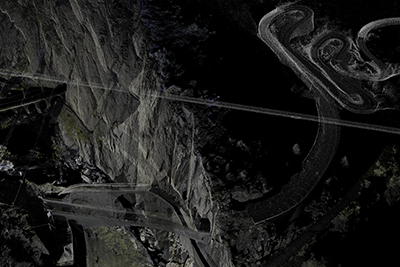
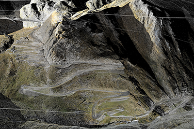
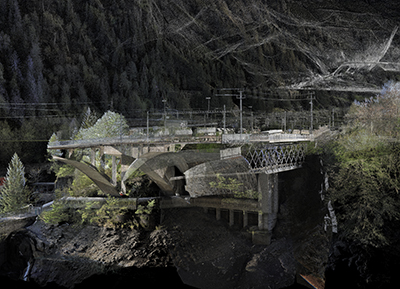
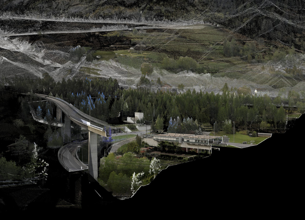
Die Visualisierungen der Professur Girot für Gotthard Landscape Infrastructure vermögen mit neuen Darstellungstechniken überirdische Felsformationen und unterirdische Tunnel in ein und dasselbe Bild zu setzten. Durch Terrestrial Laser Scanning (TLS) wurden für das Projekt grosse Teile des Gotthardraumes sowie die Tunnel darin aufgenommen und im Landscape Visualization and Modeling Lab (LVML) zu einem digitalen Modell zusammengesetzt. Mit Überflügen von Nord nach Süd und umgekehrt, der alten Passstrasse folgend, wird die Landschaft mitunter aus der Vogelperspektive gezeigt. Das Hinweggleiten über die Gotthardregion eröffnet die Wahrnehmung des Territoriums aus gänzlich neuen Blickwinkeln: mal aus der Höhe, mal nah am Boden, mal von unten dem Tunnel folgend.

Gotthardröhre und Teufelsbrücke gleichzeitig sehen

Durch die Punktwolken-Technik, in der einzelne Punkte in einem dreidimensionalen Koordinatensystem verortet sind, wird die Darstellung der Oberfläche durchlässig. Das durchlässige Modell erlaubt es Schnitte zu legen und unter die Oberfläche zu tauchen, wodurch sich neue Blicke auf die Landschaft entwickeln lassen. Objekte wie die Teufelsbrücke und die Gotthardröhre erscheinen beispielsweise im selben Bild. Verschiedene Ebenen lassen sich gleichzeitig lesen und der Raum wird mit all seinen Elementen fassbar.

Im Zuge der Eröffnung der NEAT wird das Modell im neuen Audiovisual Lab (AVL) noch um eine wesentliche Ebene erweitert: durch eine klangliche Kartierung des Raumes wird es als sogenanntes «Virtual Reality Erlebnis» erfahrbar. Dadurch entsteht das Gefühl in die Landschaft einzutauchen, vollständig von ihr umgeben zu sein: Die eigene Kopf- und Körperbewegung wird Teil des Prozesses und steht im Verhältnis zur Bewegung im virtuellen Raum. Im komplexen Zusammenspiel der Sinneswahrnehmung von Bild und Klang entsteht ein kontinuierliches und umgreifendes Raumerlebnis. Das sich in steter Weiterentwicklung befindliche Modell Gotthard Landscape möchte die Besuchenden ins Zentrum setzen und die vielschichtige, für die Schweiz so bedeutsame Gotthardlandschaft mit den neuesten audiovisuellen Technologien erfahrbar machen.

Matthias Vollmer ist wissenschaftlicher Mitarbeiter und Leiter am MediaLab der Professur Christophe Girot für Landschaftsarchitektur.

Teufelsbrücke
Tremola
Goeschenen
Share this...
  • Facebook
  • Twitter
  • Linkedin
  • Email
This article has been published in the following newsletter edition:

30 | Juni 2016: Vogelperspektive

  • Gotthard Landscape – Neue Perspektiven für eine verschollene Landschaft
  • «Wohnforschung wird an Bedeutung noch weiter zunehmen»
  • The Noise Landscape: an Emerging Urban Landscape
  • The Aerial Gaze: Iterative Aerial Site Scanning for Landscape Analysis, Planning, and Design
  • Bad for Traffic: Swiss Drivers Change Lanes too Early in Weaving Areas
  • Modeling Future Urban Scenarios for Switzerland
Kurzmeldungen
  • Ecopotential
Publikationen
  • NEAT – AlpTransit Lötschberg und Gotthard
  • Exploring the choice between in-store and online shopping
  • The Course of Landscape Architecture. A History of our Designs on the Natural World, from Prehistory to the Present
  • Urban Breeding Grounds
  • The effects of on-street parking on the service rate of nearby intersections

Chairs

Prof. Dr. Bryan T. Adey
Prof. Dr. Kay W. Axhausen
Prof. Dr. Tom Avermaete
Prof. Maria Conen
Prof. Dr. Francesco Corman
Dr. Jennifer Duyne Barenstein
Prof. Teresa Galí-Izard
Prof. Dr. Adrienne Grêt-Regamey
Prof. Dr. Guillaume Habert
Prof. Dr. David Kaufmann
Prof. Hubert Klumpner
Dr. Anastasios Kouvelas
Prof. Freek Persyn
Prof. Dr. Christian Schmid
Prof. Milica Topalovic
EiR PD Dr. Joris Van Wezemael
Prof. em Dr. h. c. Günther Vogt
ETH Wohnforum – ETH CASE

Contact

Address
ETH Zürich
NSL – Netzwerk Stadt und Landschaft
Stefano-Franscini-Platz 5
HIL H 44.2
8093 Zürich

NSL Director
Director: Prof. Hubert Klumpner
Deputy Director: Prof. Dr. David Kaufmann

NSL Coordination
Claudia Gebert
Telephone: +41 (0)44 633 36 33

Register for the NSL Newsletter

disP Publication Office

Editor-in-Chief
Dr. sc. techn. Martina Koll-Schretzenmayr, Spatial planner ETH/NDS,
Telephone +41 (0)44 633 29 47

Editorial Assistant
Telephone +41 (0)44 633 29 69

Mailing address
ETH Zürich
Redaktion disP
NSL – Netzwerk Stadt und Landschaft
Stefano-Franscini-Platz 5
HIL H 33.2
8093 Zürich
Fax +41 (0)44 633 12 15
E-Mail


NSL Archive (gta)

Research and Bequest Archive for
Swiss Landscape Architecture and Spatial Planning

Consultation Requests

Mailing address
ETH Zürich
NSL Archive (gta)
Stefano-Franscini-Platz 5
HIL C 65.2
CH-8093 Zurich