NSL – Netzwerk Stadt und Landschaft ETH Zürich
  • Projekte
      • Projekte der Professuren
        • Prof. Dr. Bryan T. Adey | Infrastrukturmanagement
        • Prof. Dr. Tom Avermaete | Geschichte und Theorie des Städtebaus
        • Prof. Dr. Kay W. Axhausen | Verkehrsplanung
        • Prof. Dr. Francesco Corman | Verkehrssysteme
        • Prof. Dr. Adrienne Grêt-Regamey | Planung von Landschaft und Urbanen Systemen
        • Prof. Dr. David Kaufmann | Raumentwicklung und Stadtpolitik
        • Prof. Hubert Klumpner | Architektur und Städtebau
        • Dr. Anastasios Kouvelas | Strassenverkehrstechnik
        • Prof. Dr. Christian Schmid | Soziologie
        • Prof. Milica Topalovic | Architektur und Territorialplanung
        • EiR PD Dr. Joris Van Wezemael | Spatial Transformation Laboratories (STL)
        • Prof. em Dr. h. c. Günther Vogt | Landschaftsarchitektur
        • ETH Wohnforum – ETH CASE
        • NSL-Archiv
      • NSL Kolloquienreihe – Präsentation herausragender Arbeit zu einem von der einladenden Professur festgelegten Thema.
      • NSL Projekte
        • Future Cities Lab Global
        • Urbane Potentiale und Strategien in metropolitanen Territorien
 – am Beispiel des Metropolitanraums Zürich (NFP65)
        • Landscape Visualization and Modeling Lab (LVML)
      • NSL Forum: Pandemie? Mitten im Klimawandel. Was bedeutet das für die räumliche Entwicklung der Schweiz? Ein Dialog.
      • Ehemalige Lehrstühle
    Close
  • Lehre
    • Lehrangebote
      • Bachelor- und Masterstudium Departement ARCH
      • Bachelor- und Masterstudium Departement BAUG
      • MSc Raumentwicklung und Infrastruktursysteme
      • MAS/CAS Raumentwicklung
      • MAS Urban and Territorial Design
      • MAS in Housing
      • Doctoral Programme in Landscape and Urban Studies
      • Die Kenntnis der für die räumlichen Entwicklungen massgebenden Kräfte und deren Zusammenwirken wie auch die Fähigkeit zur Entwicklung von Lösungsstrategien für räumliche Problemstellungen sind zentrale Voraussetzungen für verantwortungsvolles und erfolgreiches Ausüben planerischer Funktionen im Dienste öffentlicher Gemeinwesen und privater Unternehmen. Entsprechend bedeutend ist die universitäre Aus-, Weiter- und Fortbildung im Bereich der Raum-, Stadt- und Landschaftsplanung. An der ETH Zürich werden in diesem Bereich seit 1965 Fortbildungs-Kurse und Nachdiplom-Studiengänge (NDS, heute MAS) angeboten. Träger ist das NSL (Netzwerk Stadt und Landschaft).
    Close
  • Publikationen
    • Newsletter – Das NSL führt Fachleute der ETH Zürich zusammen und pflegt den Dialog mit weiteren Kreisen, die sich mit Fragen rund um Stadt und Landschaft befassen oder sich dafür interessieren.
    • Cover der Publikation: Erkenntnisse zum aktuellen WohnungsnotstandAusgewählte Publikationen der NSL–Professuren – Eine vollständige Publikationsliste mit erweiterten Suchfunktionen ist über den folgenden Link zu erreichen:
      • ETH Zürich Research Collection
    • DISP_58/3_CoverdisP – The Planning Review – Die interdisziplinäre wissenschaftliche Zeitschrift behandelt Themen aus den Bereichen Raumentwicklung, Stadtplanung/Städtebau, Landschafts- und Umweltplanung, Landschaftsarchitektur, Regional- und Umweltökonomie sowie Verkehrsplanung.
      • In disP – The Planning Review publizieren
      • Verlag
      • Richtlinien für Buchbesprechungen
      • Redaktion
      • Aktuelle Ausgabe
    Close
  • Aktuell
  • Kontakt
      • de
        • en
        • fr
        • it
      • Search

    • Close

Big Data for Assessing Ecosystem Services

Laser-scanned point-cloud model of the Green Corridor in Singapore © Philipp Urech at the ETH Chair of Prof. Christophe Girot, FCL2 Module for Ecosystem Services in Urban Environments. Visualised in Singapore Views.

The amount of spatial data about earth systems is growing, opening new doors to evaluate and quantify complex processes involving both humans and nature. Nature in cities is, for example, a key to economic performance and liveability. While the new technologies provide many new opportunities to understand and plan socio-ecological systems, it is unclear how these new technologies can successfully be implemented to shape landscapes that provide societally valued and needed qualities.

Ecosystem services (ES) provided by nature in cities are receiving increasing attention by planners and authorities. From health benefits to energy bill reductions, they contribute directly to the well-being of citizens and provide habitat for many species supporting biodiversity. 

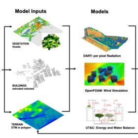
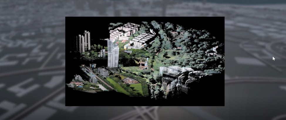
Thanks to the development of Earth Observation technologies, an increasing amount of spatial data about the planet’s physical, chemical, and biological systems is becoming available on platforms like the USGS Earth Explorer, the NASA Earth Observation, or the European spatial agency’s Sentinel, among others. From high resolution satellite images to twitter data, big data can be used to map the demand for and supply of ecosystem services. The same datasets, particularly LIDAR (light detection and ranging) can also be used by landscape architects to design changes in the landscapes or by hydrologists to understand hydrological processes. Such datasets thus provide a means for interdisciplinary workflows to shape landscapes that provide societally valued and needed qualities.

Within the Singapore Natural Capital Project that aims to assess ecosystem services in the megacity of Singapore, we carried out a pre-study to analyse the state and trends of ES using big data from satellites and global databases. General results are promising and the interdisciplinary potential of the data has been proven by assessing the cooling effect of various landscape designs.

The generation and use of these vast datasets of our environment also come along with important challenges. On one hand, many datasets are collected without a clear research aim (e.g., geotagged Twitter was never produced to provide answers with respect to the spatial distribution of people neither the drivers of such processes). The data is reflective of the technique used to generate it and holds certain characteristics. Details about the production of the dataset and the validation of the data are thus crucial to avoid mistakes in the results and interpretations. On the other hand, some datasets are not accessible to the general public or data is filtered out to provide only a selected area or a defined resolution to the user. Attention needs to be paid to secure the access to data and enhance the ability of the public to understand not only what is presented to them, but also what are the assumptions of the new technologies to generate information and choice. Another important challenge is the large computer power needed to process big data and the requirement of specific software, in addition to man power and technical skills.

While the opportunities of big data to support humans to intentionally transform landscapes are thus tremendous, the question remains on how this new data will change the way we understand and design landscapes and how we will interact with them. In particular, we will need to better understand how the use of such data can create a knowledge-driven rather than a data-driven design and planning process.

Dr. Marcelo Galleguillos is research associate at IRL-PLUS; Prof. Dr. Adrienne Grêt-Regamey is professor at IRL-PLUS.

Lesen Sie auch

Abb. 1: Konzeptueller Überblick über unseren Deep-Learning-Ansatz. Aus den sechs Eingaberastern identifizierte der Deep-Learning-Ansatz 45 Landschaftstypen. © PLUS, ETH Zürich

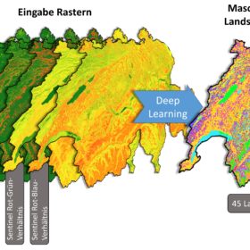
Eine neue Schweizer Landschaftstypologie mit Deep Learning
» Newsletter-Artikel

Figure 1 Ecosystem Services-Design Loop (Credit: Ecosystem Services in Urban Landscapes Project).

Introducing Ecosystem Services-Design Loop
» Newsletter-Artikel

Share this...
  • Facebook
  • Twitter
  • Linkedin
  • Email
Dieser Artikel wurde im folgenden Newsletter publiziert:

38 | Juni 2018: Big Data in der Forschung / Big Data in Research

  • Connecting Large Scale Transport Models and Mobility Trace Data
  • The New Science of Cities
  • Big Data for Assessing Ecosystem Services
  • To Exploit Big Data for the Management of Infrastructure
  • Using Macroscopic Fundamental Diagrams to Estimate Traffic Heterogeneity
Kurzmeldungen
  • NSL Kolloquium Schmelzende Landschaften: Der Film ist online!
  • Alternative Energien für Fitness- und Wellnessangebote als Beitrag zu einem nachhaltigen urbanen Lebensstil
Publikationen
  • Rift – 7.5 Views on the Jordan Valley. Pamphlet 22
  • Estimations of the Potential and the Impact of Rail Freight in Urban Areas
Aktuell
  • The Disappearance of Robin Hood
  • 1. Schweizer Landschaftskongress | 1er congrès suisse sur le paysage
  • NSL Colloquium: Re-Thinking the 21st Century City
  • Prof. Günther Vogt erhält den Ehrendoktortitel der Universität Liechtenstein
  • Ein Planer mit Herz für die Schweizer Demokratie
  • DAS Verkehrsingenieurwesen

Professuren

Prof. Dr. Bryan T. Adey
Prof. Dr. Kay W. Axhausen
Prof. Dr. Tom Avermaete
Prof. Maria Conen
Prof. Dr. Francesco Corman
Dr. Jennifer Duyne Barenstein
Prof. Teresa Galí-Izard
Prof. Dr. Adrienne Grêt-Regamey
Prof. Dr. Guillaume Habert
Prof. Dr. David Kaufmann
Prof. Hubert Klumpner
Dr. Anastasios Kouvelas
Prof. Freek Persyn
Prof. Dr. Christian Schmid
Prof. Milica Topalovic
EiR PD Dr. Joris Van Wezemael
Prof. em Dr. h.c. Günther Vogt
ETH Wohnforum – ETH CASE

Kontakt

Adresse
ETH Zürich
NSL – Netzwerk Stadt und Landschaft
Stefano-Franscini-Platz 5
HIL H 44.2
8093 Zürich

Leitung NSL
Leiter: Prof. Hubert Klumpner
Stv. Leiter: Prof. Dr. David Kaufmann

Koordinationsstelle NSL
Claudia Gebert
Telefon: +41 (0)44 633 36 33

Für den NSL Newsletter anmelden

Redaktion disP

Leitende Redaktorin
Dr. sc. techn. Martina Koll-Schretzenmayr, Raumplanerin ETH/NDS,
Telefon +41 (0)44 633 29 47

Redaktionsassistenz
Telefon +41 (0)44 633 29 69

Adresse
ETH Zürich
Redaktion disP
NSL – Netzwerk Stadt und Landschaft
Stefano-Franscini-Platz 5
HIL H 33.2
8093 Zürich
Fax +41 (0)44 633 12 15
E-Mail


NSL Archiv (gta)

Forschungs- und Nachlassarchiv für
Schweizer Landschaftsarchitektur und Raumplanung

Nutzungsanfragen

Adresse
ETH Zürich
NSL Archive (gta)
Stefano-Franscini-Platz 5
HIL C 65.2
CH-8093 Zurich