NSL – Netzwerk Stadt und Landschaft ETH Zürich
  • Projects
      • Projects of the Chairs
        • Prof. Dr. Bryan T. Adey | Infrastructure Management
        • Prof. Dr. Tom Avermaete | History and Theory of Urban Design
        • Prof. Dr. Kay W. Axhausen | Traffic and Transport Planning
        • Prof. Dr. Francesco Corman | Transport Systems
        • Prof. Teresa Galí-Izard | Chair of Being Alive
        • Prof. Dr. Adrienne Grêt-Regamey | Planning of Landscape and Urban Systems (PLUS)
        • Prof. Dr. Eva Heinen | Transportation and Mobility Planning
        • Prof. Dr. David Kaufmann | Spatial Development and Urban Policy
        • Prof. Hubert Klumpner | Architecture and Urban Design
        • Dr. Anastasios Kouvelas | Traffic Engineering and Control
        • Prof. Dr. Christian Schmid | Sociology
        • Prof. Milica Topalovic | Architecture and Territorial Planning
        • Dr. Jennifer Duyne Barenstein | ETH Wohnforum – ETH CASE
        • NSL-Archiv
      • Former Chairs
      • NSL Colloquia – The NSL Colloquia are a bi-annual presentation of exceptional work under a rotating theme determined by the inviting professor.
      • NSL Projects
          • E-Bike City
          • Future Cities Lab Global
          • Urban Potential and Strategies in Metropolitan Territories
 – The Zurich Metropolitan Region as an Example (NFP65)
          • Large-scale Virtualization and Modeling Lab (LVML)
      • NSL Forum
        • NSL Forum & Cycling Research Board
        • NSL Forum: Pandemie? Mitten im Klimawandel. Was bedeutet das für die räumliche Entwicklung der Schweiz? Ein Dialog.
    Close
  • Teaching
    • Teaching
      • Bachelor and Master Degree Programmes, Department ARCH
      • Bachelor and Master Degree Programmes, Department BAUG
      • MSc in Spatial Development and Infrastructure Systems
      • MAS/CAS in Regenerative Materials
      • CAS in Regenerative Systems: Sustainability to Regeneration
      • MAS/CAS Spatial Development
      • MAS Urban and Territorial Design
      • MAS in Housing
      • Doctoral Programme in Landscape and Urban Studies
      • The teaching component of the NSL seeks to impart the knowledge and skills needed to develop the standard strengths of spatial planning and their interaction as well as the ability to develop strategies for the solution of spatial problems. These are central prerequisites for a responsible and successful exercise of planning functions in the service of the public commonwealth and of private companies. Especially important in fufilling these prerequisites is the quality of university-level education: graduate and post-graduate work as well as professional development in spatial, urban and landscape planning. The ETH Zurich has offered programmes such as continuing education courses and post-graduate programmes (NDS, now MAS) since 1965. The NSL (Network City and Landscape) is responsible for these courses and programmes.
    Close
  • Publications
    • Cover NL 65NSL Newsletter – The NSL brings the experts at ETH Zurich together and also maintains a dialogue with other groups that deal with or are interested in issues relating to cities and landscapes.
    • A map describing the different phases of India’s neoliberal highway programme. Source: The author.Publications of NSL Chairs – A complete list of publications can be reached via the following link, which also includes advanced search capabilities:
      • ETH Zürich Research Collection
    • disP – The Planning Review – The interdisciplinary scientific journal covers the topics of spatial development, urban planning, landscape and environmental planning, landscape architecture, traffic planning, and regional and environmental economics, as well as special issues on specific themes.
      • Instructions for Authors
      • Types of Articles
      • Publisher
      • Book Review Guidelines
      • Editorial Staff
      • Latest Issue
      • facebook
    • DELUS Cover Issue 1DELUS – Journal for Landscape and Urban Studies – DELUS is an annual publication by the Institute of Landscape and Urban Studies at ETH Zürich.
    Close
  • News
  • Contact
      • en
        • de
        • fr
        • it
      • Search

    • Close
      • en
        • de
        • fr
        • it

Mapping Urban Ecosystem Services with Google

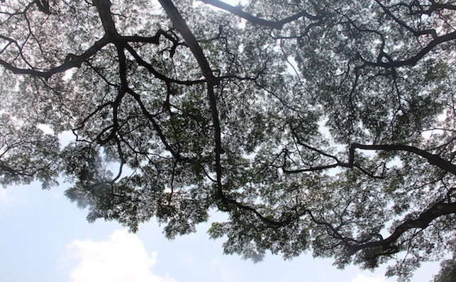
Researchers in the Future Cities Laboratory at the Singapore-ETH Centre developed a new and relatively inexpensive method to rapidly estimate the amount of shade provided by street trees. Using nearly 100,000 images from Google Street View, the study helps further our understanding on how green spaces contribute to urban sustainability. 

While it is generally accepted that trees benefit urban environments, until now researchers have had very little data to quantify the extent that street trees deliver ecosystem services. Most of the research has been conducted in temperate zones of Europe and North America, and little is known about how trees contribute to urban ecosystems in tropical regions such as Singapore, which experience high solar radiation on a daily basis.

Researchers in the Future Cities Laboratory (FCL) at the Singapore-ETH Centre developed a method to map and quantify how street trees may contribute to regulating the temperature. Using nearly 100,000 images from Google Street View, they analysed hemispherical photographs using an algorithm to quantify green canopy coverage at 50 metre intervals across more than 80% of Singapore’s road network.

Google Street View’s technology allows researchers to tap a standard dataset of panoramic photographs and streetscapes that use a global positioning system (GPS) to map images to specific locations at high spatial resolution.

Reducing Flash Floods and Cleaning Air

«In addition to cooling urban microclimates, these trees, which are integrated within dense urban street networks, also provide benefits such as reducing flash floods and cleaning the air,» says Peter Edwards, Principal Investigator at the FCL. Researchers on the project stated that increasing street tree canopy coverage could reduce ground surface and air temperatures on Singapore’s streets. In addition, the relative quantity of the canopy may also serve as an indicator of evaporative cooling from leaves and rainfall interception.

«Providing trees to help cool the environment and improve thermal comfort for people is particularly important in tropical cities like Singapore, which suffers heavily from the urban heat island effect,» says Dan Richards, a postdoctoral researcher at the FCL and the project’s coordinator.

This new and relatively inexpensive method of rapidly estimating the amount of shade provided by street trees could help urban planners to identify areas of a city with low shade and prioritise the planting of new trees. Since Google Street View covers many cities, the method could be readily applied to quantify canopy coverage and solar radiation in other tropical cities and even adapted to the temperate zone.

With urban populations exploding in megacities like Shenzhen, Shanghai, and Delhi to well over 20 million people, it is important to understand the contribution of greenery to urban sustainability.

The chair Planning of Landscape and Urban Systems (PLUS) of Adrienne Grêt-Regamey is part of this research ‘Ecosystem services in urban landscapes’ at the Future Cities Laboratory (FCL) in Singapore.

Richards, Daniel R.; Edwards, Peter J. (2017): Quantifying street tree regulating ecosystem services using Google Street View. In: Ecological Indicators. 77. S.31–40. More

Share this...
  • Facebook
  • Linkedin
  • Whatsapp
  • Email
This article has been published in the following newsletter edition:

33 | März 2017: Ein Blick zurück

  • Das Wissen von der Stadt
  • Die Landschaft lesen
  • Was uns historische Verkehrskarten verraten
  • Backcasting – Looking Backwards to Reach the Desired Future
  • Pathways of Post-Socialist Urban Development. The Case of Budapest
  • «Prof. Milica Topalovic: What is Territorial Planning?»
  • Mapping Urban Ecosystem Services with Google
Kurzmeldungen
  • The People’s Museum
  • ETH Zürich am WEF 2017 in Davos: «Magic through Technology»
Publikationen
  • Architecture Competition: Project Design and the Building Process.
  • Investigation of a static and a dynamic neighbourhood methodology to develop work programs for multiple close municipal infrastructure networks
  • Delta Dialogues. Heft Nr. 20 der Schriftenreihe «Pamphlet»
  • Extending Morris method for qualitative global sensitivity analysis of models with dependent inputs
  • Estimating pedestrian speed using aggregated literature data
  • Der intelligente Parkplatz: Elektronisch gesteuertes, dynamisches Preissystem

Chairs

Prof. Dr. Bryan T. Adey
Prof. Dr. Kay W. Axhausen
Prof. Dr. Tom Avermaete
Prof. Maria Conen
Prof. Dr. Francesco Corman
Dr. Jennifer Duyne Barenstein
Prof. Teresa Galí-Izard
Prof. Dr. Adrienne Grêt-Regamey
Prof. Dr. Guillaume Habert
Prof. Dr. Eva Heinen
Prof. Damian Jerjen
Prof. Dr. David Kaufmann
Prof. Hubert Klumpner
Dr. Anastasios Kouvelas
Prof. Freek Persyn
Prof. Dr. Christian Schmid
Prof. Milica Topalovic
Prof. Martina Voser

Contact

Address
ETH Zürich
NSL – Netzwerk Stadt und Landschaft
Stefano-Franscini-Platz 5
HIL H 44.2
8093 Zürich

NSL Director
Director: Prof. Dr. David Kaufmann
Deputy Director: Prof. Milica Topalovic

NSL Coordination
Claudia Gebert
Telephone: +41 (0)44 633 36 33


Register for the NSL Newsletter

disP Publication Office

Editor-in-Chief
Dr. sc. techn. Martina Koll-Schretzenmayr, Spatial planner ETH/NDS,
Telephone +41 (0)44 633 29 47

Mailing address
ETH Zürich
Redaktion disP
NSL – Netzwerk Stadt und Landschaft
Stefano-Franscini-Platz 5
HIL H 33.3
8093 Zürich
Fax +41 (0)44 633 12 15
E-Mail


NSL Archive (gta)

Research and Bequest Archive for
Swiss Landscape Architecture and Spatial Planning

Consultation Requests

Mailing address
ETH Zürich
NSL Archive (gta)
Stefano-Franscini-Platz 5
HIL C 65.2
CH-8093 Zurich


Privacy Policy