From Design to Research to Play: A Co-creative Process for Designing a Serious Game on Flood Management
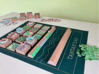
TANTAN’EAU – a wordplay merging «Tantano» (to manage in Malagasy) and «Eau» (water in French) – is a serious game that helps decision-makers explore flood risk management. Designed to balance playability, realism, and the incorporation of architectural propositions, it immerses players in the challenges of peri-urban development in More
Venice Biennale: Designs of Resilient Landscapes for Flood-Prone Areas of Antananarivo
10 May – 23 November 2025 | 19th International Architecture Exhibition of La Biennale di Venezia.
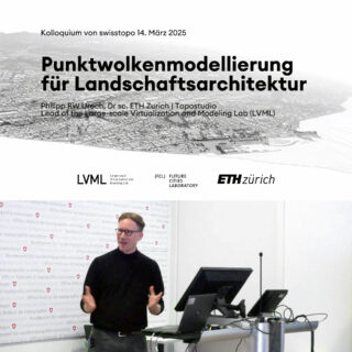
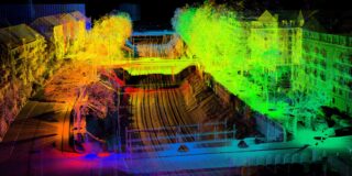
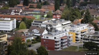
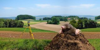
Swisstopo-Kolloquium: Präzisionsmodellierung auf grossem Massstab in der Landschaftsarchitektur
Nach sechs Jahren LiDAR-Vermessung aus der Luft ist nun die klassifizierte Punktwolke der Schweiz – swissSURFACE3D – für das gesamte Schweizer Territorium verfügbar. Zu diesem Anlass präsentierte Dr. Philipp Urech Forschungsarbeiten aus dem Large-scale Virtualization and Modeling Lab (LVML), ergänzt durch praktische Beispiele seiner wegweisenden Methode für die More

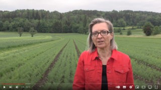
Den Lebensraum der Zukunft gestalten
Der ETH Master-Studiengang Raumentwicklung und Infrastruktursysteme bietet eine fundierte, interdisziplinäre Ausbildung in Stadtplanung, Mobilität und Infrastrukturmanagement. Durch die Verbindung von Theorie und Praxis entwickeln Studierende nachhaltige Lösungen für aktuelle Herausforderungen. In Kooperation mit Professorinnen, Professoren und Studierenden ist ein kurzes Video entstanden, um Studieninteressierte für diesen Fachbereich und More
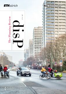
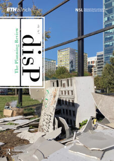
disP 60/3, September 2024
disP – The Planning Review, Volume 60, Issue 3, September 2024 is now available online on Taylor & Francis Online.

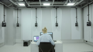
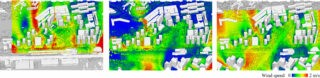
Developing a Unity-based Tool to Integrate Sound into Landscape Design and Evaluation
The acoustic quality of outdoor spaces is receiving increasing attention in planning and design disciplines. Yet, it is very difficult for non-experts in acoustics to include the effects of landscape changes on the so-called soundscape in their daily work. In the Innovedum project «Unity App for Soundscape Design More
disP 60/2, June 2024
disP – The Planning Review, Volume 60, Issue 2, June 2024 is now available online on Taylor & Francis Online.
Tagung Landmanagement 2025: Klimaresilientes Wassermanagement im ländlichen Raum
23. Januar 2025 | ETH Zürich, Audimax, HG F 30, Rämistrasse 101.

How Ukraine can rebuild its energy system
Researchers at ETH Zurich have been working with researchers from Ukraine and Germany to investigate how to rebuild Ukraine’s destroyed energy infrastructure based on renewable energy. They have determined that solar and wind energy would quickly deliver a distributed power supply system and prevent corruption. Article at the More
Renewable energies in the field of tension between social demands
The Swiss energy system is set to undergo a significant transformation through the integration of photovoltaic (PV) and wind energy installations, as outlined in the Energy Strategy 2050. However, these installations impact public perception of the landscape and may lead to conflicts with various socio-economic or ecological interests. More
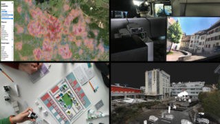
Virtualizing Urban Transition
At a time of global anthropogenic paroxysms, initiatives for urban transition are multiplying to ensure quality and resilience of life in cities. In particular, public open space holds immense potential for rapid adaptation to mitigate the severe risks to human health arising from global warming, pollution and pandemics. More

Planungstools zur besseren Integration von Biodiversität und Ökosystemleistungen in raumrelevante Entscheidungen
Der Aktionsplan Biodiversität soll den Zustand der Biodiversität in der Schweiz verbessern. Ein wichtiger Faktor ist der Einbezug von Ökosystemleistungen/Biodiversität in Raumentscheidungen. In einem Bundesmandat wurde eine Übersicht zu Planungstools erstellt, die dabei helfen können. Es wurden planungsinvolvierte Personen interviewt, um Hindernisse und Nachfrage nach Planungstools zu identifizieren.
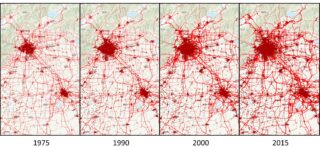
Globale Modellierung des ländlichen Strassenverkehrs ausserhalb der Städte
Der Verkehr auf ländlichen Strassen ausserhalb der Städte kann erhebliche negative Auswirkungen auf die Ökologie und Umwelt von Natur- und Agrarlandschaften haben. Der Umfang dieser Auswirkungen kann jedoch nicht bestimmt werden, da in vielen Ländern keine Daten zum Verkehrsvolumen auf ländlichen Strassen verfügbar sind. Deshalb haben wir einen More

In Gedenken an Willy A. Schmid
Willy A. Schmid war von 1978 bis 2008 Professor für Landschafts- und Umweltplanung am Institut für Raum- und Landschaftsentwicklung (IRL), der heutigen Professur für Planung von Landschaft und Urbanen Systemen (PLUS) und Mitbegründer des Netzwerk Stadt und Landschaft (NSL) an der ETH Zürich. Er hat Generationen von Raum- und Landschaftsplaner:innen More
MAS ETH in Regenerative Systems
CAS#2 Beyond Systems Thinking. Applications: 11 March to 7 April 2024, Duration: May-September 2024. The new MAS in Regenerative Systems (DRRS) is a systemic programme for designerly enacting complex systems in a highly innovative didactic setting.
disP 59/3, September 2023
disP – The Planning Review, Volume 59, Issue 3, September 2023 is now available online on Taylor & Francis Online.
Escape Determinism – Unlocking Desirable Urban Development Pathways
Look around you – what do you see? Unique urban landscapes with specific characteristics, identities, and landmarks? Or homogenous urban landscapes repeating similar shapes, materials, colours, and functions? Currently, homogeneity dominates the day-to-day realities of the European population, of which 74% already lives in urban landscapes. Homogeneity is More

Adrienne Grêt-Regamey ist Dandelion Award Winner 2023
17 Professor:innen für Start-up-Förderung geehrt.

NSL Veranstaltungsplakat Herbstsemester 2023
Das neue NSL Veranstaltungsplakat Herbstsemester 2023 ist da!
Designing Resilient Regenerative Systems (DRRS)
Registration: MOOC anytime; next CAS/MAS planned from November 2023.
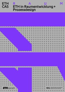
CAS in Raumentwicklung und Prozessdesign
Im Kontext der urbanen Transformation verschwimmen die Grenzen unserer Stadt-, Quartiers-, und Immobilienentwicklung zunehmend. Es braucht neue Verfahrenskombinationen, um die Ziele einer nachhaltigen Stadtentwicklung zu erreichen.
BAB – Intercantonal Coordinated Monitoring of Construction Outside Building Zones
Pilot regions, the federal government and the Chair of Planning of Landscape and Urban Systems (PLUS) are jointly drafting which questions and indicators related to building outside building zones should be answered or recorded in the cantons in the future in the scope of a monitoring (BAB). The More
LVML-Integration into Design++ at the ETH Zurich
The Large-Scale Virtualization and Modeling Lab (LVML) becomes part of Design++, the Center for Augmented Computational Design in Architecture, Engineering and Construction. It opens its usage to Design++ members to foster interdisciplinary collaboration and supports knowledge integration and co-creation to advance planning and design tools and workflows. Contact: More
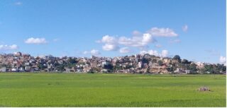
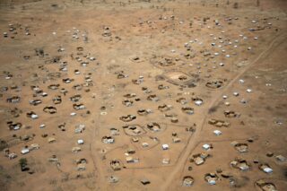
Documenting and Promoting Multifunctional Agro-urban Landscape for Resilient Cities: a Case Study in Antananarivo
Antananarivo serves as a prominent example of how urban agriculture can effectively provide essential services for creating sustainable and resilient cities, specifically addressing food security and flood control challenges. The FCL Global research project has made significant contributions through landscape designs that prioritise and advance these crucial services, More
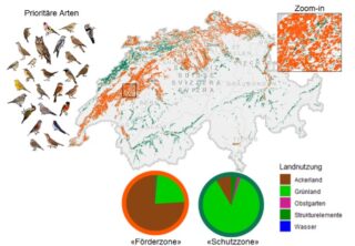
Fokusgebiete für den Schutz und die Förderung von Vogelarten der Schweizer Landwirtschaft
Die landwirtschaftliche Nutzung beeinflusst die Artenvielfalt, die zu schützen eine Herausforderung darstellt. Eine Studie hat potenzielle Verbreitungsgebiete prioritärer Vogelarten (Artverbreitungsmodelle) mit der landwirtschaftlichen Nutzungsauswirkung (Ökobilanzierung) verbunden. Basierend darauf wurde eine räumlich explizite Karte mit Fokusgebieten für den Erhalt und die Förderung dieser Arten produziert.
10 Jahre RPG 1
2. November, 14:00 – 17:00 | ETH Zürich, Zentrum, HG E3. Das Inkrafttreten der Revision des Raumplanungsgesetzes jährt 2024 zum zehnten Mal.
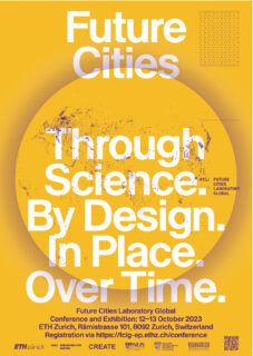
Future Cities Laboratory Global Conference and Exhibition
12 – 13 October | ETH Zurich, Rämistr. 101. It is no longer enough to promote innovative science and design, we need to move from research to action. Keynotes: Peter Sloterdijk, Pierre de Meuron, Momoyo Kaijima and others.

Opening of the ‘Large-scale Virtualization and Modeling Lab – LVML’
3 October 2023, 16:00–18:00 | ETH Zürich, Hönggerberg, HIL H 40.9 (Foyer).
disP 59/1, March 2023
disP – The Planning Review, Volume 59, Issue 1, March 2023 is now available online on Taylor & Francis Online.
Wer bin ich? Die Agglo auf der Suche nach Identität
Sendung Regionaljournal Bern Freiburg Wallis, 22.05.2023, 17:30 Uhr. Was Agglomerationsgemeinden tun können, um sich nicht in der Gesichtslosigkeit zu verlieren. Zwei Beispiele.
Design Research Studios – A Research-based Design Process for Interdisciplinary Dialogue and Collaborative Thinking
Design Research Studios (DRS) are an education format directed to Bachelor and Master students in Architecture at ETH Zurich that integrate studies conducted by post-graduate researchers on complex issues like flood and urban heat. They offer an opportunity to develop landscape designs connecting people and their environment with More
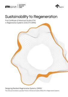
CAS in Regenerative Systems: Sustainability to Regeneration
Crises hold chances. We are finding ourselves in times of deep, nested, and accelerating ecological, social, cultural, political, economic, and personal crises. This dynamic situation is highly complex and uncertain, unpredictable, and even chaotic. Yet within chaos is creativity, and creativity leads to chances for renewal.


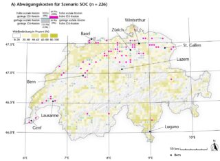
Wo sollen Windräder in der Schweiz stehen?
Eine Studie von ETH-Forschenden zeigt erstmals, wie sich die Lockerung der Raumplanung auf den Ausbau der Windenergie in der Schweiz auswirken würde. Will man möglichst wenig Windanlagen in den Alpen und in der Schweiz generell, sollte man die Nutzung von windstarken Agrarflächen im westlichen Mittelland erwägen. Artikel in More
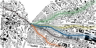
Reviewing the Resilience Concept for Designing more Adaptive and Innovative Systems
A recently published review paper on mountain resilience identifies origins of the resilience concept with earliest roots in material, infrastructure, and physical resilience. Resilience today is seen beyond shock absorption towards transforming a system for making it stronger, as both more adaptive and more innovative. Several future engagement More
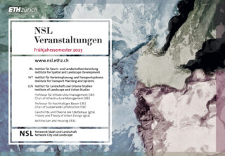
NSL Veranstaltungsplakat Frühjahrssemester 2023
Das neue NSL Veranstaltungsplakat Frühjahrssemester 2023 ist da!
Flood Risk Mitigation in Refugee Settlements
The intensity and frequency of natural hazards are on the rise. Refugee settlements face a particular risk from such disruptive events due to their precarious built environment and socio-economic situation. The SPUR and PLUS research groups at ETH Zürich, in collaboration with UNHCR and the Swiss Development Cooperation More

Schatzkammer Wald: Lebensraum, Inspirationsquelle, Ressource
4. März–26. November | Ausstellung im Museum Burghalde Lenzburg.
disP 58/3, September 2022
disP – The Planning Review, Volume 58, Issue 3, September 2022 is now available online on Taylor & Francis Online.
Difference in Urban Planning. Interdisciplinarity as an Approach to Understanding the Complexity of Contemporary Urban Societies
Cities attract people of diverse origins, religious practices, socioeconomic status, and everyday practices. As a result, urban planning is challenged to respond adequately to this demographic heterogeneity. These urbanization processes highlight the importance of placing difference at the centre of the urban planning agenda.
disP 58/2, June 2022
disP – The Planning Review, Volume 58, Issue 2, June 2022 is now available online on Taylor & Francis Online.
NSL Veranstaltungsplakat Herbstsemester 2022
Das neue NSL Veranstaltungsplakat Herbstsemester 2022 ist da!
Globescape: Understanding Place, Fostering Place-making
Unprecedented urbanisation is transforming productive agricultural land into standardised settlements in which people are losing their sense of place and the motivation to initiate change. How people feel about, interact with, or want different places to be shaped, has been systematically researched through the lenses of place and More
Landmanagement – Weiterentwicklung eines Instrumentariums
18. Januar 2023, 9:00 – 17:00 | ETH Zürich (Zentrum), Auditorium Maximum HG F 30. Das Landmanagement ist im Wandel. Schon heute werden seine Instrumente zur Förderung vielfältiger Funktionen des Raumes eingesetzt.
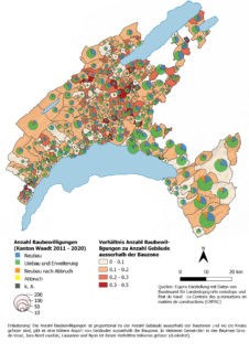
Interkantonal koordiniertes Monitoring Bauen ausserhalb Bauzonen
Am 3. Schweizer Landschaftskongress in Rapperswil hat die ETH Zürich in Kooperation mit dem Kanton Waadt das Projekt für ein interkantonal koordiniertes Monitoring zum Bauen ausserhalb der Bauzonen vorgestellt. Das Ziel des Projekts ist die partizipative Entwicklung von Indikatoren basierend auf bestehenden Datengrundlagen. Wer den Posterbeitrag verpasst hat, More
Eine kurze Geschichte des Bauens ausserhalb der Bauzone
Warum gibt es in der Schweiz eine Trennung zwischen Baugebiet und Nicht-Baugebiet? Was waren die Beweggründe, das Bauen ausserhalb der Bauzone streng zu reglementieren? Welche Akteure setzten sich für die Trennung ein und wie lief der politische Prozess ab? Antworten gibt diese kurze Geschichte des Bauens ausserhalb der More
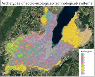
Archetypes of Socio-ecological-technological-systems for Managing Ecological Infrastructure
The Valpar.CH project assesses the current state of the ecological infrastructure (EI) as well as the basis for a functioning EI in the future. To examine EI and communicate results, we delineate archetypes by clustering socio-economic, ecological, and technological indicators using machine-learning techniques. Within the boundaries of the More
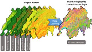
Eine neue Schweizer Landschaftstypologie mit Deep Learning
Die Identifizierung und Definition von Landschaftstypen ist nicht nur für die Übertragbarkeit von Landschaftsplanungs- und Managementstrategien unerlässlich, sondern auch eine Anforderung der von der Schweiz ratifizierten Europäischen Landschaftskonvention. Landschaftstypologien werden in der Regel von Expert:innen oder mit Hilfe sogenannter unsupervised clustering Techniken erstellt. Die letztgenannten Methoden haben jedoch More
disP 57/3, September 2021
disP – The Planning Review, Volume 57, Issue 3, September 2021 is now available online on Taylor & Francis Online.