NSL – Netzwerk Stadt und Landschaft ETH Zürich
  • Progetti
      • Progetti delle cattedre
        • Prof. Dr. Bryan T. Adey | Gestione delle infrastrutture
        • Prof. Dr. Tom Avermaete | Storia e teoria dell’urbanistica
        • Prof. Dr. Kay W. Axhausen | Pianificazione dei trasporti
        • Prof. Dr. Francesco Corman | Sistemi di trasporto
        • Prof. Teresa Galí-Izard | Chair of Being Alive
        • Prof. Dr. Adrienne Grêt-Regamey | Pianificazione paesaggistica e sistemi urbani
        • Prof. Dr. Eva Heinen | Pianificazione dei trasporti e della mobilità
        • Prof. Dr. David Kaufmann | Sviluppo del territorio e politica urbana
        • Prof. Hubert Klumpner | Architettura e Urbanistica
        • Dr. Anastasios Kouvelas | Ingegneria e controllo del traffico
        • Prof. Dr. Christian Schmid | Sociologia
        • Prof. Milica Topalovic | Architettura e pianificazione territoriale
        • Dr. Jennifer Duyne Barenstein | ETH Wohnforum – ETH CASE
        • NSL-Archiv
      • Ex cattedre
      • Colloqui NSL – Il colloquio NSL è una presentazione semestrale di lavori eccellenti. Il tema viene stabilito di volta in volta dal professore che presenta l’invito.
      • Progetti NSL
          • E-Bike City
          • Future Cities Lab Global
          • Urbane Potentiale und Strategien in metropolitanen Territorien
 – am Beispiel des Metropolitanraums Zürich (NFP65)
          • Large-scale Virtualization and Modeling Lab (LVML)
      • NSL Forum
        • NSL Forum & Cycling Research Board
        • NSL Forum: Pandemie? Mitten im Klimawandel. Was bedeutet das für die räumliche Entwicklung der Schweiz? Ein Dialog.
    Close
  • Insegnamento
    • Insegnamento
        • Bachelor e Master dipartimento ARCH
        • Bachelor e master dipartimento BAUG
        • MSc in Sviluppo territoriale e sistemi infrastrutturali
        • MAS/CAS in Regenerative Materials
        • CAS ETH in Regenerative Systems: dalla sostenibilità alla rigenerazione
        • MAS/CAS Pianificazione del territorio
        • MAS Urban and Territorial Design
        • MAS ETH in edilizia abitativa
        • Doctoral Programme in Landscape and Urban Studies
      • La conoscenza delle forze decisive per lo sviluppo del territorio e la loro interazione, nonché la capacità di sviluppo di strategie risolutive per problematiche territoriali rappresentano i presupposti centrali per lo svolgimento responsabile ed efficace di funzioni di pianificazione al servizio della collettività e di imprese private. Altrettanto importanti sono la formazione, il perfezionamento e l'agggiornamento universitari nel settore della pianificazione territoriale, urbana e del paesaggio. Dal 1965 l'ETH di Zurigo offre corsi di aggiornamento e percorsi di studi post-laurea (NDS, oggi MAS) in questo ambito. I corsi sono gestiti dalla Rete Scientifica Città e Paesaggio (NSL).
    Close
  • Pubblicazioni
    • Cover NL 65Newsletter – NSL riunisce esperti dell’ETH di Zurigo e cura il dialogo con altri ambienti che si occupano o si interessano di questioni relative alla città e al paesaggio.
    • A map describing the different phases of India’s neoliberal highway programme. Source: The author.Pubblicazioni delle cattedre di NSL – Un elenco completo delle pubblicazioni con funzioni di ricerca avanzate è disponibile al seguente link:
      • ETH Zürich Research Collection
    • disP – The Planning Review – La rivista scientifica interdisciplinare tratta temi legati a sviluppo territoriale, urbanistica, pianificazione paesaggistica e ambientale, architettura del paesaggio, economia regionale e ambientale e pianificazione del traffico.
      • Istruzioni per autori / autrici
      • Types of Articles
      • Editore
      • Guida per la stesura di recensioni letterarie
      • Redazione
      • Ultimo numero
      • facebook
    • DELUS Cover Issue 1DELUS – Journal for Landscape and Urban Studies – DELUS è una pubblicazione annuale dell’Istituto di studi urbani e del paesaggio dell’ETH di Zurigo.
    Close
  • Attualità
  • Contatto
      • it
        • de
        • en
        • fr
      • Search

    • Close
      • it
        • de
        • en
        • fr

Simulation of complex pedestrian facilities: Case study of Lausanne main station

Pedestrian simulation software can be a powerful tool for analyzing highly complex pedestrian infrastructures. In this case it was applied to determine the effects of the planned complete redesign of Lausanne main station’s subterranean pedestrian architecture. The simulation model featured over one hundred origin and destination points as well as an intricate underground tunnel system with dozens of hallways, ramps and crossings.

Lausanne’s main railway station will be reconstructed and extended in the near future. The Swiss Federal Railways (SBB) infrastructure will be adapted to future needs, which will involve widening the train platforms. However, because of the urban situation the platforms cannot exceed 10 meters width. To address the lacking pedestrian space, three underpasses are planned to distribute passengers uniformly onto the platforms. Simultaneously, the metro system of the Transports Publics de la Région Lausannoise (TL) will be extended by moving the m2 line and implementing a new m3 line. The planned changes require the subterranean pedestrian facilities connecting the m2 and m3 platforms with SBB platforms to be completely redesigned. The aim is to achieve an optimal distribution of the vastly increased numbers of passengers across the three underpasses, whilst maintaining satisfying service and safety levels for all pedestrians.

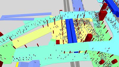
A Complex System of Subterranean Hallways

In 2015 the ETH Institute for Transport Planning and Systems analyzed the proposed construction plans in a study for the canton of Vaud, TL and SBB. The research method consisted of pedestrian simulations using PTV’s VISWALK software, as well as analytical calculations of the expected numbers of waiting passengers on the metro platforms situated directly below the station square. Because of the crowded rush hour timetable in Lausanne and the extremely limited underground space in the station vicinity, the simulation model consisted of a complex architectural system of subterranean hallways, ramps and crossings, as well as an origin-destination matrix with roughly a thousand cells.

The results show that the northbound m2 platform is expected to be the most heavily used area in the entire Lausanne train station. The high numbers of passengers in the morning rush hour will likely require special pedestrian guidance measures in order for daily operations to run smoothly and safely. Other parts of the underground facility like the pedestrian space between the m2 and m3 metro lines and the areas around the stairs leading to the SBB train platforms will also be heavily crowded. For these areas, the study recommends additional pedestrian measures like rounded corners and removing all types of obstacles from the hallways and underpasses. Lastly, the study showed that the middle underpass will be used most intensively by a large margin in the busier morning rush hour.

Ernst Bosina und Mark Meeder are scientific assistants at the Institute for Transport Planning and Systems IVT. Their main field of research is pedestrian traffic.

Share this...
  • Facebook
  • Linkedin
  • Whatsapp
  • Email
Questo contributo è stato pubblicato nella seguente newsletter:

29 | März 2016: Unter der Oberfläche

  • Güterversorgung aus dem Untergrund
  • Geomorphic Agent – Ab- und Aufbaulandschaften im Anthropozän
  • Simulation of complex pedestrian facilities: Case study of Lausanne main station
  • Soil Quality and Land Use
  • Above vs. Beneath the Surface: What Happens When a Tunnel Solution Fails?
  • Lifestyle Exercise
Kurzmeldungen
  • New AudioVisual Lab
  • Cooperative Production of Low-Cost Housing – Socio-Technological Innovation for the Provision of Housing for Low-Income Populations
  • Schenkungen der Familie Kienast an das NSL
  • Autonomous Cars – The Next Revolution in Mobility
Publikationen
  • achtung: die Landschaft. Lässt sich die Stadt anders denken? Ein erster Versuch
  • Dieter Kienast. Stadt und Landschaft lesbar machen
  • Adaptive control algorithm to provide bus priority with a pre-signal
  • Wunderlust/Wanderkammer

Cattedre

Prof. Dr. Bryan T. Adey
Prof. Dr. Kay W. Axhausen
Prof. Dr. Tom Avermaete
Prof. Maria Conen
Prof. Dr. Francesco Corman
Dr. Jennifer Duyne Barenstein
Prof. Teresa Galí-Izard
Prof. Dr. Adrienne Grêt-Regamey
Prof. Dr. Guillaume Habert
Prof. Dr. Eva Heinen
Prof. Damian Jerjen
Prof. Dr. David Kaufmann
Prof. Hubert Klumpner
Dr. Anastasios Kouvelas
Prof. Freek Persyn
Prof. Dr. Christian Schmid
Prof. Milica Topalovic
Prof. Martina Voser

Contatto

Indirizzo
ETH Zürich
NSL – Netzwerk Stadt und Landschaft
Stefano-Franscini-Platz 5
HIL H 44.2
8093 Zürich

Direzione NSL
Direttore: Prof. Dr. David Kaufmann
Vicedirettrice: Prof. Milica Topalovic

Ufficio di coordinamento NSL
Claudia Gebert
Telefono: +41 (0)44 633 36 33


Iscriviti alla newsletter della NSL

Redazione disP

Caporedattrice
Dr. sc. techn. Martina Koll-Schretzenmayr, pianificatrice territoriale ETH/NDS,
Telefono +41 (0)44 633 29 47

Indirizzo
ETH Zürich
Redaktion disP
NSL – Netzwerk Stadt und Landschaft
Stefano-Franscini-Platz 5
HIL H 33.3
8093 Zürich
Fax +41 (0)44 633 12 15
E-Mail

Archivio NSL (gta)

Archivio storico e di ricerca per l’architettura
del paesaggio e la pianificazione ambientale svizzere

Richieste di consultazione

Indirizzo
ETH Zürich
NSL Archive (gta)
Stefano-Franscini-Platz 5
HIL C 65.2
CH-8093 Zurich


Protezione dei dati