NSL – Netzwerk Stadt und Landschaft ETH Zürich
  • Projets
      • Projets des chaires
        • Prof. Dr. Bryan T. Adey | Gestion des infrastructures
        • Prof. Dr. Tom Avermaete | Histoire et théorie de l’urbanisme
        • Prof. Dr. Kay W. Axhausen | Planification des transports
        • Prof. Dr. Francesco Corman | Systèmes de transport
        • Prof. Dr. Adrienne Grêt-Regamey | Aménagement du paysage et des systèmes urbains
        • Prof. Dr. David Kaufmann | Aménagement du territoire et politique urbaine
        • Prof. Hubert Klumpner | Architecture et urbanisme
        • Dr. Anastasios Kouvelas | Ingénierie de trafic et surveillance
        • Prof. Dr. Christian Schmid | Sociologie
        • Prof. Milica Topalovic | Architecture et aménagement du territoire
        • EiR PD Dr. Joris Van Wezemael | Spatial Transformation Laboratories (STL)
        • Prof. em Dr. h. c. Günther Vogt | Architecture du paysage
        • ETH Wohnforum – ETH CASE
        • Archive NSL
      • Colloques NSL – Le colloque NSL consiste en une présentation semestrielle d’un travail remarquable. Le thème est à chaque fois défini par la chaire qui invite.
      • Projets NSL
        • Future Cities Lab Global
        • Stratégies et potentiels urbains dans des territoires métropolitains d’après l’exemple de l’espace métropolitain de Zurich (PNR 65)
        • Landscape Visualization and Modeling Lab (LVML)
      • NSL Forum: Pandemie? Mitten im Klimawandel. Was bedeutet das für die räumliche Entwicklung der Schweiz? Ein Dialog.
      • Anciennes chaires
    Close
  • Enseignement
    • Enseignement
      • Bachelor et mastère, departement ARCH
      • Bachelor et mastère département BAUG
      • MSc en Développement territorial et Systèmes d’infrastructures
      • MAS/CAS Aménagement du territoire
      • MAS Urban and Territorial Design
      • MAS ETH en logement
      • Doctoral Programme in Landscape and Urban Studies
      • La connaissance des forces déterminantes pour les développements territoriaux et de leurs concomitances, mais aussi l'aptitude au développement de stratégies de solutions pour les problématiques territoriales, sont des conditions centrales pour l'exercice responsable et efficace des missions de conception au service de collectivités publiques ou d'entreprises privées. Tout aussi décisifs sont les formations universitaires initiale et continue, et le perfectionnement dans les disciplines d'aménagements territorial, urbain et paysager. L'ETH Zurich propose dans ces disciplines depuis 1965 des cours de formation continue et des cycles d'études post-diplôme (NDS, aujourd'hui MAS). Ils sont organisés par le Réseau Ville et Paysage (NSL).
    Close
  • Publications
    • Newsletter – Le NSL rassemble des experts de l’ETH Zurich et entretient un dialogue avec d’autres milieux qui traitent ou s’intéressent à des questions liées à la ville et au paysage.
    • Cover der Publikation: Erkenntnisse zum aktuellen WohnungsnotstandPublications des chaires du NSL – La liste complète des publications avec option de recherche avancée peut être atteinte via le lien suivant:
      • ETH Zürich Research Collection
    • DISP_58/3_CoverdisP – The Planning Review – La revue scientifique interdisciplinaire traite de thèmes tirés des domaines suivants: aménagement du territoire, aménagement urbain/urbanisme, aménagement du paysage et de l’environnement, architecture du paysage, économie régionale et de l’environnement, mais aussi planification des transports.
      • Publier dans disP – The Planning
      • Editeur
      • Directives pour les comptes-rendus de livres
      • Rédaction
      • Version actuelle
      • facebook
    Close
  • Actualités
  • Contact
      • fr
        • de
        • en
        • it
      • Search

    • Close

Simulation of complex pedestrian facilities: Case study of Lausanne main station

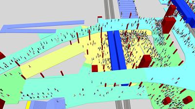
Pedestrian simulation software can be a powerful tool for analyzing highly complex pedestrian infrastructures. In this case it was applied to determine the effects of the planned complete redesign of Lausanne main station’s subterranean pedestrian architecture. The simulation model featured over one hundred origin and destination points as well as an intricate underground tunnel system with dozens of hallways, ramps and crossings.

Lausanne’s main railway station will be reconstructed and extended in the near future. The Swiss Federal Railways (SBB) infrastructure will be adapted to future needs, which will involve widening the train platforms. However, because of the urban situation the platforms cannot exceed 10 meters width. To address the lacking pedestrian space, three underpasses are planned to distribute passengers uniformly onto the platforms. Simultaneously, the metro system of the Transports Publics de la Région Lausannoise (TL) will be extended by moving the m2 line and implementing a new m3 line. The planned changes require the subterranean pedestrian facilities connecting the m2 and m3 platforms with SBB platforms to be completely redesigned. The aim is to achieve an optimal distribution of the vastly increased numbers of passengers across the three underpasses, whilst maintaining satisfying service and safety levels for all pedestrians.

A Complex System of Subterranean Hallways

In 2015 the ETH Institute for Transport Planning and Systems analyzed the proposed construction plans in a study for the canton of Vaud, TL and SBB. The research method consisted of pedestrian simulations using PTV’s VISWALK software, as well as analytical calculations of the expected numbers of waiting passengers on the metro platforms situated directly below the station square. Because of the crowded rush hour timetable in Lausanne and the extremely limited underground space in the station vicinity, the simulation model consisted of a complex architectural system of subterranean hallways, ramps and crossings, as well as an origin-destination matrix with roughly a thousand cells.

The results show that the northbound m2 platform is expected to be the most heavily used area in the entire Lausanne train station. The high numbers of passengers in the morning rush hour will likely require special pedestrian guidance measures in order for daily operations to run smoothly and safely. Other parts of the underground facility like the pedestrian space between the m2 and m3 metro lines and the areas around the stairs leading to the SBB train platforms will also be heavily crowded. For these areas, the study recommends additional pedestrian measures like rounded corners and removing all types of obstacles from the hallways and underpasses. Lastly, the study showed that the middle underpass will be used most intensively by a large margin in the busier morning rush hour.

Ernst Bosina und Mark Meeder are scientific assistants at the Institute for Transport Planning and Systems IVT. Their main field of research is pedestrian traffic.

Share this...
  • Facebook
  • Twitter
  • Linkedin
  • Email
Cet article a été publié dans le newsletter suivant:

29 | März 2016: Unter der Oberfläche

  • Güterversorgung aus dem Untergrund
  • Lifestyle Exercise
  • Above vs. Beneath the Surface: What Happens When a Tunnel Solution Fails?
  • Soil Quality and Land Use
  • Simulation of complex pedestrian facilities: Case study of Lausanne main station
  • Geomorphic Agent – Ab- und Aufbaulandschaften im Anthropozän
Kurzmeldungen
  • Cooperative Production of Low-Cost Housing – Socio-Technological Innovation for the Provision of Housing for Low-Income Populations
  • New AudioVisual Lab
  • Autonomous Cars – The Next Revolution in Mobility
  • Schenkungen der Familie Kienast an das NSL
Publikationen
  • Wunderlust/Wanderkammer
  • Adaptive control algorithm to provide bus priority with a pre-signal
  • Dieter Kienast. Stadt und Landschaft lesbar machen
  • achtung: die Landschaft. Lässt sich die Stadt anders denken? Ein erster Versuch

Chaires

Prof. Dr. Bryan T. Adey
Prof. Dr. Kay W. Axhausen
Prof. Dr. Tom Avermaete
Prof. Maria Conen
Prof. Dr. Francesco Corman
Dr. Jennifer Duyne Barenstein
Prof. Teresa Galí-Izard
Prof. Dr. Adrienne Grêt-Regamey
Prof. Dr. Guillaume Habert
Prof. Dr. David Kaufmann
Prof. Hubert Klumpner
Dr. Anastasios Kouvelas
Prof. Freek Persyn
Prof. Dr. Christian Schmid
Prof. Milica Topalovic
EiR PD Dr. Joris Van Wezemael
Prof. em Dr. h. c. Günther Vogt
ETH Wohnforum – ETH CASE

Contact

Adresse
ETH Zürich
NSL – Netzwerk Stadt und Landschaft
Stefano-Franscini-Platz 5
HIL H 44.2
8093 Zürich

Direction NSL
Directeur: Prof. Hubert Klumpner
Représentant du directeur: Prof. Dr. David Kaufmann

Bureau de coordination NSL
Claudia Gebert
Téléphone: +41 (0)44 633 36 33

Inscrivez-vous à la newsletter NSL

Rédaction disP

Rédactrice responsable
Dr. sc. techn. Martina Koll-Schretzenmayr, aménageuse territoriale ETH/NDS,
Téléphone +41 (0)44 633 29 47

Assistance de rédaction
Téléphone +41 (0)44 633 29 69

Adresse
ETH Zürich
Redaktion disP
NSL – Netzwerk Stadt und Landschaft
Stefano-Franscini-Platz 5
HIL H 33.2
8093 Zürich
Fax +41 (0)44 633 12 15
Adresse électronique

Archive NSL (gta)

Archives de recherche et posthumes pour l’architecture du paysage et l’aménagement du territoire suisses.

Recherche

Adresse
ETH Zürich
NSL Archive (gta)
Stefano-Franscini-Platz 5
HIL C 65.2
CH-8093 Zurich