NSL – Netzwerk Stadt und Landschaft ETH Zürich
  • Projects
      • Projects of the Chairs
        • Prof. Dr. Bryan T. Adey | Infrastructure Management
        • Prof. Dr. Tom Avermaete | History and Theory of Urban Design
        • Prof. Dr. Kay W. Axhausen | Traffic and Transport Planning
        • Prof. Dr. Francesco Corman | Transport Systems
        • Prof. Dr. Adrienne Grêt-Regamey | Planning of Landscape and Urban Systems (PLUS)
        • Prof. Dr. David Kaufmann | Spatial Development and Urban Policy
        • Prof. Hubert Klumpner | Architecture and Urban Design
        • Dr. Anastasios Kouvelas | Traffic Engineering and Control
        • Prof. Dr. Christian Schmid | Sociology
        • Prof. Milica Topalovic | Architecture and Territorial Planning
        • EiR PD Dr. Joris Van Wezemael | Spatial Transformation Laboratories (STL)
        • Prof. em Dr. h. c. Günther Vogt | Landscape Architecture
        • ETH Wohnforum – ETH CASE
        • NSL Archive
      • NSL Colloquia – The NSL Colloquia are a bi-annual presentation of exceptional work under a rotating theme determined by the inviting professor.
      • NSL Projects
        • Future Cities Lab Global
        • Urban Potential and Strategies in Metropolitan Territories
 – The Zurich Metropolitan Region as an Example (NFP65)
        • Landscape Visualization and Modeling Lab (LVML)
      • NSL Forum: Pandemie? Mitten im Klimawandel. Was bedeutet das für die räumliche Entwicklung der Schweiz? Ein Dialog.
      • Former Chairs
    Close
  • Teaching
    • Teaching
      • Bachelor and Master Degree Programmes, Department ARCH
      • Bachelor and Master Degree Programmes, Department BAUG
      • MSc in Spatial Development and Infrastructure Systems
      • MAS/CAS Spatial Development
      • MAS Urban and Territorial Design
      • MAS in Housing
      • Doctoral Programme in Landscape and Urban Studies
      • The teaching component of the NSL seeks to impart the knowledge and skills needed to develop the standard strengths of spatial planning and their interaction as well as the ability to develop strategies for the solution of spatial problems. These are central prerequisites for a responsible and successful exercise of planning functions in the service of the public commonwealth and of private companies. Especially important in fufilling these prerequisites is the quality of university-level education: graduate and post-graduate work as well as professional development in spatial, urban and landscape planning. The ETH Zurich has offered programmes such as continuing education courses and post-graduate programmes (NDS, now MAS) since 1965. The NSL (Network City and Landscape) is responsible for these courses and programmes.
    Close
  • Publications
    • NSL Newsletter – The NSL brings the experts at ETH Zurich together and also maintains a dialogue with other groups that deal with or are interested in issues relating to cities and landscapes.
    • Cover der Publikation: Erkenntnisse zum aktuellen WohnungsnotstandPublications of NSL Chairs – A complete list of publications can be reached via the following link, which also includes advanced search capabilities:
      • ETH Zürich Research Collection
    • DISP_58/3_CoverdisP – The Planning Review – The interdisciplinary scientific journal covers the topics of spatial development, urban planning, landscape and environmental planning, landscape architecture, traffic planning, and regional and environmental economics, as well as special issues on specific themes.
      • Publishing in disP – The Planning Review
      • Publisher
      • Book Review Guidelines
      • Editorial Staff
      • Latest Issue
      • facebook
    Close
  • Current
  • Contact
      • en
        • de
        • fr
        • it
      • Search

    • Close

25 | März 2015: Mapping

Geschätzte Leserinnen und Leser

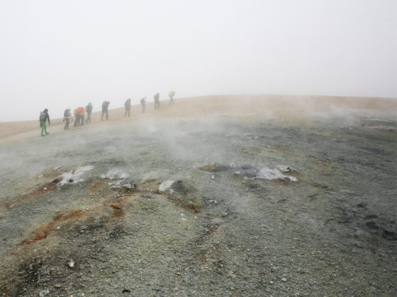
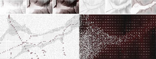
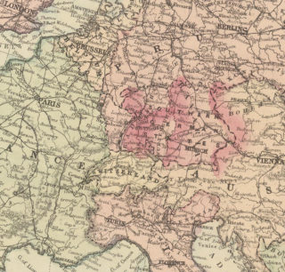
Eine abstrakte Darstellung von Raum ist nicht nur notwendiges Arbeitsinstrument, sonden auch eine zu erlernende professionelle Fähigkeit. Mapping ist so vielfältig wie deren Autorinnen und Autoren und beeinflusst Verwendungszweck und -möglichkeiten. In Zentral-Island setzten Studierende die erlernten Methoden subjektiv um; im Lehrgang MAS Landscape Architecture wird eine Fülle digitaler Daten zum Entwurf; ein Dissertationsprojekt nutzt historische Verkehrskarten, um territoriale Konflikte zu erklären; in Südafrika wird mit Hilfe der Anwohnerinnen und Anwohner ein Slum mittels diverser Mapping-Methoden aufgewertet; und in Jakarta wurde die ökologisch herausfordernde Kartierung des Ciliwung beendet.

Mapping Everything

Die Darstellung von Raum auf Karten, Plänen und in Modellen ist so vielfältig, wie es ihre spezifischen Zwecke sind, die Darstellungsformen so variabel wie die Raumwahrnehmung ihrer Autorinnen und Autoren. Im Rahmen der Summer School Mapping Everything setzen sich die Studierenden der Professur Vogt, Landschaftsarchitektur, mit der Kartographierung ortsspezifischer Interessen und Aspekten auseinander und lernen unterschiedliche Methoden und Techniken der Raumwahrnehmung. In der diesjährigen Summer School ging die Reise nach Zentral-Island wo die expeditionsmässige Annäherung an die Orte Technik und Methode des Prozesses und somit die Inhalte der Projekte bestimmte.  More

When the Dog is Dead, Throw it in the River – Mapping and the Challenges of the Ciliwung

Urban rivers facing pressure from rapid urbanisation often take on multiple roles beyond their natural ecological function. The Ciliwung River flows through the megacity of Jakarta and is located in West Java, Indonesia. Along with many rivers in Southeast Asia it has become an environmental buffer to Jakarta’s poorly managed waste. A popular Javanese jingle from the 1990’s includes the phrase: «…when the dog is dead, throw it in the river», and serves to illustrate some of the complex cultural factors behind the long-compromised role of Indonesia’s rivers. More

Geographies of Opportunity

The Urban-Think Tank Chair of Architecture and Urban Design recently launched a two-year design research project in the informal settlements of Cape Town, South Africa, with field surveys, commented walks and the design and facilitation of a series of open workshops. Referencing methods of participation from the Informal Settlement Network (ISN), the team is developing a customized and scalable methodology for the upgrade of a pilot site in BT-Section, Khayelitsha. More

Verkehrsinfrastruktur, Macht, Staat

Was haben alte Verkehrskarten mit Boko Haram zu tun? Einiges – das zeigt das Forschungsprojekt Effect of Resource Endowments and Limited State Capacity on Political Conflict. Dabei ist der Gedanke zentral, wonach staatliche Präsenz und Machtausübung eng mit der Erreichbarkeit eines Territoriums und somit letzten Endes mit der Qualität des Transportsystems verbunden sind. More

«Explorative Data-Mapping – Experimental Teaching Tools» innerhalb des MAS in Landscape Architecture

Welche Methoden sind notwendig, um innerhalb des Entwurfprozesses aus der Fülle der vorhandenen Datensätze relevante Informationen zu identifizieren? Wie lassen sich diese Daten visualisieren, um anschliessend aussagekräftige Entscheidungen für den Entwurf ableiten zu können? Dieses Thema erforschen wir experimentell innerhalb des MAS LA Moduls: «Progamming Landscape». More

Kurzmeldungen

Improving Pedestrian Mobility Through Bottom-Up Strategies, ETH-EiABC Workshop 2014 Addis Ababa Ethiopia

The transdisciplinary workshop held in Addis Ababa aimed at making pedestrian mobility safer and more convenient in an increasingly car-oriented urban environment. Framed by the workshop’s focus on advancing viable ideas for low-cost mobility, twenty students from ETH Zurich and the Ethiopian Institute of Architecture, Building Construction and City Development (EiABC) developed a range of strategies how to design pedestrian infrastructure in a more integrative and equitable manner. Basil Vitins

Workshops zur Kartierung von Ökosystemleistungen

Um Ökosysteme und ihre Leistungen zu erhalten ist es wichtig zu wissen, wo und in welcher Quantität diese erbracht werden. Je nach Fragestellung werden dazu unterschiedliche Karten erstellt. Zur Unterstützung der Umsetzung der EU-Biodiversitätsstrategie schulen Mitarbeitende der Professur PLUS zusammen mit Wissenschaftlern der Universität Wageningen in einer Serie von Workshops Fachleute aus verschiedenen EU-Ländern im Mapping von Ökoystemleistungen. Mehr

Effiziente Flughafenerschliessungssysteme im Hinblick auf die Landnutzung an Flughäfen

Das anhaltende Wachstum des Luftverkehrs und die zunehmende Entwicklung von «Airport Cities» erzeugen ein grösseres und stärker gemischtes Verkehrsaufkommen an Flughäfen. Diese Arbeit untersucht, ob dadurch das Potential besteht, aufgrund einer gleichmässigeren Nachfragestruktur als an bisherigen ÖV-Knoten Flughäfen zu natürlichen Knotenpunkten im öffentlichen Verkehr zu entwickeln. Hermann Orth

NSM – Advancing the Model for Safety Improvement of the Road Network in the City of Zurich

Network Safety Management (NSM) is a road safety tool to identify locations of the highest potential for improving road infrastructure. The aim is to test different variations of input parameters for the city of Zurich. Thereby, a prioritization of the three network elements traffic oriented roads, nodes and residential zones is made. The findings are used to further improve NSM as a road safety analysis tool. Marco Rothenfluh

Teilnehmende für Eye-Tracking-Studie gesucht

Zum Thema «Visualisierung und Kommunikation von Ökosystemleistungen» wird momentan eine Eye-Tracking-Studie durchgeführt. Anhand eines aktuellen raumplanerischen Themas werden Zusammenhänge zwischen dargestellter Information und Visualisierungen sowie aufgabenspezifischen Anforderungen an raumbezogene Kommunikation ermittelt. Interessierte sind herzlich eingeladen daran teilzunehmen (Dauer: ca. 35–45 Min, Ort: Zürich, ETH Hönggerberg). Weitere Informationen und Anmeldung

Neue Studienleitung des MAS, CAS, DAS Raumplanung

Anita Grams wird ab 1.9. 2015 neue Studienleiterin des Master of Advanced Studies (MAS) in Raumplanung und der angeschlossenen CAS/DAS Raumplanung an der ETH Zürich. Sie tritt die Nachfolge von Felix Günther an, der die Studienleitung von 2009 bis 2015 wahrgenommen hat.

Informationsblatt MASRP

Publikationen

This is a selection. Find a complete list in the ETH Zürich Research Collection.

Simpson, Deane

Young-Old: Urban Utopias of an Aging Society.

Zürich: Lars Müller Publishers.   More
Young-Old examines contemporary architectural and urban mutations that have emerged as a consequence of one of the key demographic transformations of our time: aging populations. Distinguishing between different phases of old age, the book identifies the group known as the «young old» as a remarkable petri dish for experiments in subjectivity, collectivity, and environment. 

Rossano, Frédéric

From absolute protection to controlled disaster: New perspectives on flood management in times of climate change

In: Journal of Landscape Architecture, 10 (1). S.16–25.  More
How we conceive of flood disaster and the means to protect ourselves have evolved radically through centuries. Following centuries of deluge angst and blinding technicism, current adaptation projects bring about a new perspective that reintegrates flooding into spatial perception and territorial design, but also give rise to new myths that challenge the ethics of landscape architects.

Ortigosa, Javier; Menendez, Monica; Gayah, V.

Analysis of the Network Exit Functions for different urban grid network configurations

In: Transportation Research Record: Journal of the Transportation Research Board (accepted or in press). More
This paper analyses traffic performance on an abstract grid network with different street configurations using the Network Exit Function (NEF) – an aggregate relationship between trip-completion rate and the number of vehicles circulating in a network.

Brillembourg, Alfredo; Klumpner, Hubert

Forget About Utopia

In: Hou, Jeffrey; Spencer, Benjamin; Way, Thaisa; Yocom, Ken (Hrsg.): Now Urbanism: The Future City Is Here. Routledge.  More
This book explores the intersections of critical inquiry and immediate, substantive actions. The contributions recognize the rich complexities of the present city not as barriers or obstacles but as grounds for uncovering opportunity and unleashing potential. It views city making as grounded in the imperfect, messy, yet rich reality of the existing city and the everyday purposeful agency of its dwellers.

Bierlaire, Michel; Palma, André de; Hurtubia, Ricardo; Waddell, Paul (Hrsg.)

Integrated Transport and Land Use Modeling for Sustainable Cities

Lausanne: EPFL Press, distributed by Routledge.  More
Sustainable development is a goal of planners and politicians and ever more prominent for urban areas where development agglomerates. The SustainCity consortium further developed the methodology and tools for integrated modelling and analysis of land use transport systems. The IVT implemented a microsimulation for the Canton of Zurich. 

Barth, Emanue

How international borders affect local public transport: Analyses and evaluations of cross-border agglomerations in Switzerland. France and Germany

Dissertation, IVT-Schriftenreihe Nr. 167  PDF
This dissertation report examines the various effects that international borders exert on local public transport systems in high density agglomerations with regard to demand, passenger expectations and framework conditions. Furthermore, it identifies related challenges and derives approaches and recommendations from the analysis.

Redaktionsteam

Susann Ahn, Institut für Landschaftsarchitektur

Patrick Bösch, Institut für Verkehrsplanung und Transportsysteme
Claudia Gebert, Koordinationsstelle NSL, Chefredaktion
Lukas Küng, Institut für Städtebau
Alexis Kalagas, Institut für Städtebau
Bettina Weibel, Institut für Raum- und Landschaftsentwicklung

  • 57 | März 2023: Landschafts- und Klimawandel / Landscape and Climate Change
  • 56 | Dezember 2022: Trans-disziplinarität
  • 55 | September 2022: Ort / Place
  • 54 | Juni 2022: Artificial Intelligence / Machine Learning
  • 53 | März 2022: Agency
  • 52 | Dezember 2021: Risiko / Risk
  • 51 | September 2021: Umwelt im Wandel / Transitional Environments
  • 50 | Juni 2021: Nothilfe / Emergency Aid
  • 49 | März 2021: Future Cities Lab Global
  • 48 | Dezember 2020: Communication | Mediation
  • 47 | September 2020: Umgang mit Krisen / Adaption to Crisis
  • 46 | Juni 2020: Partizipation II / Participation II
  • 45 | May 2020: Partizipation I / Participation I
  • 44 | Dezember 2019: Methoden / Methods
  • 43 | September 2019: Verdichtung / Density
  • 42 | Juni 2019: Politik und Raum / Politics and Space
  • 41 | April 2019: Urbane Qualität / Urban Quality
  • 40 | Dezember 2018: Technologie beeinflusst Verhalten / Technology Influences Behaviour
  • 39 | Oktober 2018: Öffentlicher Raum / Public Space
  • 38 | Juni 2018: Big Data in der Forschung / Big Data in Research
  • 37 | März 2018: Arbeiten im internationalen Umfeld / International Context Work
  • 36 | Dezember 2017: Geräuschkulissen
  • 35 | September 2017: Ressourcen
  • 34 | Juni 2017: Ein Blick in die Zukunft
  • 33 | März 2017: Ein Blick zurück
  • 32 | Dezember 2016: Infrastrukturen
  • 31 | September 2016: Bezahlbar wohnen
  • 30 | Juni 2016: Vogelperspektive
  • 29 | März 2016: Unter der Oberfläche
  • 28 | Dezember 2015: Stadt und Nahrung
  • 27 | September 2015: Abschlussbericht Future Cities Laboratory FCL
  • 26 | Mai 2015: Nationalfondsprojekt 65, Neue Urbane Qualität: Abschlussberichte
  • 25 | März 2015: Mapping
  • 24 | Dezember 2014: Energie(wende)
  • 23 | September 2014: Resilienz
  • 22 | Juni 2014: Aktivitäten des NSL-Mittelbaus
  • 21 | März 2014: Informelle Siedlungen
  • 20 | Dezember 2013: Visualisierungen
  • 19 | September 2013: Bahn und Raumentwicklung
  • 18 | Juni 2013: Verdichtung
  • 17 | März 2013: Weiterbildung am NSL
  • 16 | Dezember 2012: Nationalfondsprojekt 65: Neue Urbane Qualität
  • 15 | September 2012: Inter- und Transdisziplinarität
  • 14 | Juni 2012: Wissenstransfer
  • 13 | März 2012: Projekte des Future Cities Laboratory in Singapur
  • 12 | Dezember 2011: Wasser / Landschaft
  • 11 | September 2011: Infrastrukturen
  • 10 | Juni 2011: Risiko
  • 09 | März 2011: Analyse unseres Verhaltens in den Städten
  • 08 | Dez. 2010: Alpenraum und Nord-Süd Transversale
  • 07 | Sept. 2010: Daten sammeln, archivieren, zur Verfügung stellen
  • 06 | Juni 2010: Mobilität
  • 05 | März 2010: Bilder und Videos
  • 04 | Dez. 2009: Gesellschaft / Soziologie
  • 03 | Sept. 2009: Nachhaltigkeit
  • 02 | Juni 2009: Städtebau
  • 01 | März 2009: Weiterbildung am NSL

Chairs

Prof. Dr. Bryan T. Adey
Prof. Dr. Kay W. Axhausen
Prof. Dr. Tom Avermaete
Prof. Maria Conen
Prof. Dr. Francesco Corman
Dr. Jennifer Duyne Barenstein
Prof. Teresa Galí-Izard
Prof. Dr. Adrienne Grêt-Regamey
Prof. Dr. Guillaume Habert
Prof. Dr. David Kaufmann
Prof. Hubert Klumpner
Dr. Anastasios Kouvelas
Prof. Freek Persyn
Prof. Dr. Christian Schmid
Prof. Milica Topalovic
EiR PD Dr. Joris Van Wezemael
Prof. em Dr. h. c. Günther Vogt
ETH Wohnforum – ETH CASE

Contact

Address
ETH Zürich
NSL – Netzwerk Stadt und Landschaft
Stefano-Franscini-Platz 5
HIL H 44.2
8093 Zürich

NSL Director
Director: Prof. Hubert Klumpner
Deputy Director: Prof. Dr. David Kaufmann

NSL Coordination
Claudia Gebert
Telephone: +41 (0)44 633 36 33

Register for the NSL Newsletter

disP Publication Office

Editor-in-Chief
Dr. sc. techn. Martina Koll-Schretzenmayr, Spatial planner ETH/NDS,
Telephone +41 (0)44 633 29 47

Editorial Assistant
Telephone +41 (0)44 633 29 69

Mailing address
ETH Zürich
Redaktion disP
NSL – Netzwerk Stadt und Landschaft
Stefano-Franscini-Platz 5
HIL H 33.2
8093 Zürich
Fax +41 (0)44 633 12 15
E-Mail


NSL Archive (gta)

Research and Bequest Archive for
Swiss Landscape Architecture and Spatial Planning

Consultation Requests

Mailing address
ETH Zürich
NSL Archive (gta)
Stefano-Franscini-Platz 5
HIL C 65.2
CH-8093 Zurich