The Future is (the Housing) Cooperative
The future of affordable and adequate housing is one of the most urgent global challenges. UN-Habitat estimates that from 2016 until the year 2030 close to 3 billion people will have to find new shelter, which would mean to complete approximately 4000 housing units per hour. When looking Continua
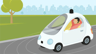
Autonome Fahrzeuge auf der Überholspur?
Die vierte industrielle Revolution, das heisst die Automatisierung der Arbeitswelt, rollt über uns hinweg. Auch und gerade im Transportsektor sind die Änderungen spürbar und noch lange nicht abgeschlossen. Schon heute sind neue Akteure im Markt, die mit Digitalisierung und Automatisierung traditionelle Strukturen unter Druck bringen – das vermutlich Continua
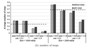
Isolated intersection control for various levels of vehicle technology: Conventional, connected, and automated vehicles
In: Transportation Research Part C: Emerging Technologies, Volume 72, November 2016. S.109-129, ISSN 0968-090X. More This paper proposes an efficient signal control algorithm under the co-existence of conventional vehicles, connected vehicles and automated vehicles. Trajectories of the automated vehicles are modified to reduce delay and stops. Simulations show that both Continua
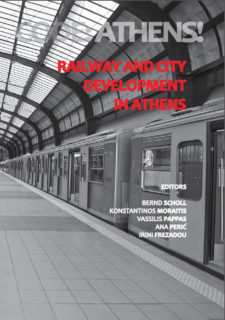
CODE: ATHENS! Railway and City Development in Athens
In: Transportation Research Part C, Emerging Technologies 71. S.382-405. More This paper reviews and classifies the traffic optimisation schemes of current mainline railway into two groups: improve efficiency of traffic management by providing resolutions for traffic conflicts; or improve trains’ driving behaviour by providing driver assistance or introducing train Continua
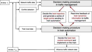
A new rail optimisation model by integration of traffic management and train automation
In: Transportation Research Part C, Emerging Technologies 71. S.382-405. More This paper reviews and classifies the traffic optimisation schemes of current mainline railway into two groups: improve efficiency of traffic management by providing resolutions for traffic conflicts; or improve trains’ driving behaviour by providing driver assistance or introducing train Continua
Impact of autonomous vehicles on the accessibility in Switzerland
Arbeitsberichte Verkehrs- und Raumplanung, 1177. Zürich: IVT, ETH Zürich. PDF More Autonomous vehicles are expected to offer higher comfort of traveling at lower prices whilst increasing road capacity. Using the Swiss national transport model, this research simulates the impact of autonomous vehicles on accessibility. The results show substantial impacts favoring urban sprawl Continua
Voreingenommene Erzählungen. Architekturgeschichte als Ideengeschichte
Zürich: gta Verlag. Mehr Die in diesem Buch versammelten Aufsätze wurden nicht als akademische Übungen verfasst, sondern aus einer genuinen Neugierde heraus. Immer spüren sie den Ideen hinter den Architekturen nach. Sie gehören einer Architekturgeschichte an, die über die Form hinaus Erkundungen anstellt nach Ideologien, politischen Verhältnissen, gesellschaftlichen Bedingungen, Continua
Thinking the Contemporary Landscape
New York: Princeton Architectural Press. More Examining our shifting perceptions of nature and place in the context of environmental challenges and how these affect urbanism and architecture, the seventeen essayists in Thinking the Contemporary Landscape argue for an all-encompassing view of landscape that integrates the scientific, intellectual, aesthetic, and Continua
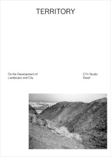
Territory – On the Development of Landscape and City
Park Books More From 2008 to 2014, ETH Studio Basel, under the guidance of Roger Diener and Marcel Meili, investigated the process of urbanization taking place outside cities. Territory brings together the results of their research in six significant locations: the Nile Valley; Rome-Adria, Italy; the Florida hinterlands; the Red River Delta Continua
![]()
Impacts of non-aeronautical development at airports on public transport
Dissertation, IVT-Schriftenreihe Nr. 175. In an increasingly intertwined world, airports are the link between local ground and global air transport. Many have grown beyond that function and have become commercial, business and leisure centres, as well as ground transport interchanges. This research showed that not only airport operators Continua

Die Stadt der Moderne. Strategien zu Erhaltung und Planung
Zürich: gta Verlag. Wie können die städtebaulichen Zeugnisse des 20. Jahrhunderts, die als Avantgarde-Produkte oft bewusst kurzlebig angelegt wurden, in Gegenwart und Zukunft erhalten werden? Wie soll die Denkmalpflege mit der modernen Stadt umgehen? Neun Fallbeispiele zu europäischen Städten, Ensembles und Siedlungen veranschaulichen die schwierige Balance zwischen Bewahren Continua
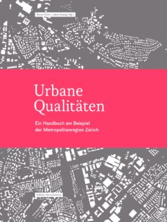
Urbane Qualitäten. Ein Handbuch am Beispiel der Metropolitanregion Zürich
Zürich: Edition Hochparterre. Unsere Siedlungsgebiete haben sich grundlegend verändert: Agglomerationen, Städte, Dörfer und Landschaften bilden metropolitane Netzwerke, neue funktionale Zusammenhänge und räumliche Strukturen sind entstanden. Dieses Handbuch verschafft Orientierung und hilft Qualitäten und Defizite in urbanen Gebieten festzustellen. Als praxisorientiertes Arbeitsinstrument richtet sich das Buch an alle, die sich mehr für Qualitäten Continua
NEAT – AlpTransit Lötschberg und Gotthard
ETR-Swiss Spezial. Hamburg: DVV Media Group. Mehr Die Sonderausgabe von ETR-Swiss vereint Artikel zu Entstehungsgeschichte, Planung, Bau, Bahntechnik und Betrieb der NEAT-Projekte und wagt einen Ausblick auf die Perspektiven, welche sie für Personen- und Güterverkehr schaffen.

Exploring the choice between in-store and online shopping
Paper to be presented at the 23rd EIRASS conference on Recent Advances in Retailing and Service Strategies, Edinburgh, July 2016. More The paper aims at explaining the choice between online and in-store shopping, applying an integrated choice and latent variable modeling approach. An increased acceptance level of online shopping Continua
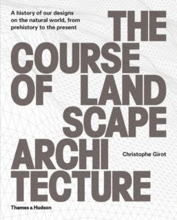
The Course of Landscape Architecture. A History of our Designs on the Natural World, from Prehistory to the Present
London: Thames & Hudson. More In many ways the history of civilization is a history of humans’ relationship with nature. Starting from the dual inclination to clear land for cultivation and to enclose space for protection, there emerges a vital and multifaceted narrative that describes our cultural relationship Continua
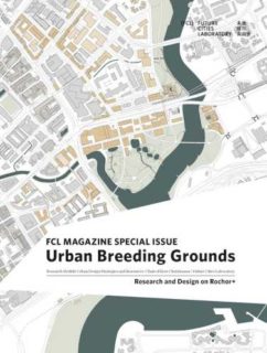
Urban Breeding Grounds
FCL magazine special issue: Urban Breeding Grounds More The FCL Magazine Special Issue presents the investigation of the mechanisms of a diverse inner city neighbourhood in Singapore termed ‘Rochor +’. The articles not only illustrate the high economic and spatial potential of urban breeding grounds, but also provide an instrumentarium Continua
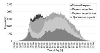
The effects of on-street parking on the service rate of nearby intersections
In: Journal of Advanced Transportation, 50 (4). S.406-420. PDF More An on-street parking maneuver often starts a temporary bottleneck, leading to additional delay endured by the following vehicles. If the maneuver occurs near a signalized intersection, the service rate of the intersection might be reduced. In this paper, a Continua

Wunderlust/Wanderkammer
Lars Müller Publishers. Mehr Eine Wunderkammer entzieht sich ausdrücklich einer Klassifizierung. Diese Sammlung, genau wie die Wunderkammer, ist weder eine Monographie, noch ein Katalog oder ein Buch. In drei Bänden – Collecting, Recording und Translating – reflektiert diese hybride Kollektion über den Inhalt und Ethos einer vom Case Studio VOGT gestalteten Wunderkammer.
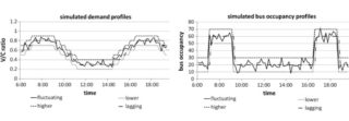
Adaptive control algorithm to provide bus priority with a pre-signal
In: Transportation Research Part C: Emerging Technologies, 64. S.28-44. More The paper establishes the first real-time control algorithm for pre-signals. The algorithm combines multiple operation strategies at the intersection. It functions well with a wide range of input values and is robust to input errors. The real-time pre-signal minimizes person Continua
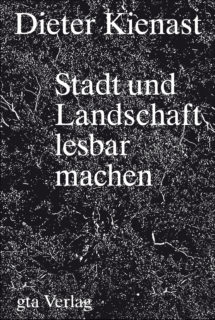
Dieter Kienast. Stadt und Landschaft lesbar machen
Zürich: gta. Mehr Mit einer markanten Ästhetik für die Natur der Stadt und der Verbindung von Gestaltung und Ökologie hat Dieter Kienast (1945–1998) die Disziplin der Landschaftsarchitektur neu orientiert. Anette Freytag geht der Entwurfshaltung und den theoretischen Positionen des unorthodoxen Denkers nach, dessen hohe Sensibilität für Material und Continua
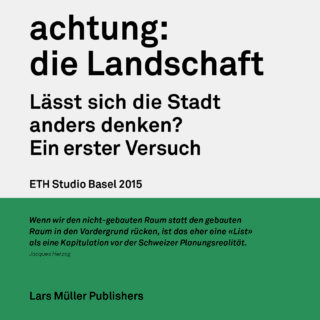
achtung: die Landschaft. Lässt sich die Stadt anders denken? Ein erster Versuch
Lars Müller Publishers. Mehr In freier Anspielung auf das Plädoyer achtung: die Schweiz von 1955 schlägt achtung: die Landschaft eine neue, radikale Sichtweise vor. Indem man sich auf die zentrale Rolle der Landschaft – Land, Landschaft und das gesamte nicht-gebaute Gebiet – als Remedium gegen die Zersiedelung zurückbesinnt, ermöglicht der Blick auf die Continua
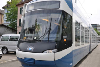
Stand des Wissens zu Schweizer Tramsystemen im Mischverkehr
Forschungsprojekt im Rahmen der COST Action TU1103: Operation and safety of tramways in interaction with public space. IVT-Schriftenreihe Nr. 174. Mehr Die Studie fasst den Stand des Wissens zur Sicherheit von Schweizer Tramsystemen im Mischverkehr zusammen. Sie beschreibt relevante regulatorische Aspekte, analysiert die aktuelle Situation der Tramsicherheit in Continua
Exploring the application of latent class cluster analysis for investigating pedestrian crash injury severities in Switzerland
In: Accident Analysis & Prevention, 85. S.219-228. Mehr One of the challenges in traffic safety analyses is the heterogeneous nature of safety data. The study suggests that latent class clustered regression approach is suitable for reducing heterogeneity and revealing important hidden relationships in traffic safety analyses.
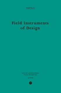
Field Instruments of Design
Heft Nr. 19 der Schriftenreihe «Pamphlet». Zürich: gta Verlag. Mehr This issue of Pamphlet argues that it is impossible to design landscapes without a thorough knowledge of field instruments – they measure the geometry of the land, observe and describe physical features, and help to conceive the «Topology» of Continua
Reclaiming Backlanes: Design Vision for Increasing Building Performance and Reprogramming Common Spaces
Singapore: Future Cities Laboratory (FCL). Mehr Based on a project at the FCL to reprogramme backlanes of shophouses into viable and high quality common spaces, while improving energy efficiency by 50%. These design visions mark the convergence of studies in energy efficiency, pedestrian movement, historic building stock analysis and Continua
Required autonomous vehicle fleet sizes to serve different levels of demand
Paper to be presented at the 95th Annual Meeting of the Transportation Research Board, Washington, D.C., January 2016. Mehr If Autonomous Vehicles (AV) are used predominantly as shared vehicles, they promise a reduction of the required total fleet size. Using a simulation approach, this paper shows that – given certain Continua
Brachlandschaften / Wastelands
In: Goldbach, Ines (Hrsg.): Lara Almarcegui. Kunsthaus Baselland. Basel: Christoph Merian Verlag. S.113–121. Mehr Die Verbrachung von grossflächigen Landschaftsräumen ist ein weltweit zunehmendes Phänomen, das speziell in Europa zu einer rasanten Transformation traditioneller Kulturlandschaften führt. Der Artikel zeigt auf, wie die Verwilderung und starke Verwaldung von ehemaligen Landwirtschaftsflächen unser Continua
Habitat Marocain Documents: Dynamics Between Formal and Informal Housing
Zurich: Park Books. Mehr Casablanca’s Habitat Marocain housing project was built between 1954 and 1956 by the Swiss architects Jean Hentsch and André Studer. The book explores the process of designing and building Habitat Marocain, as well as the increasingly informal further development of the project. Habitat Marocain Continua
radikal normal. Positionen zur Architektur der Stadt
Ostfildern: Hatje Cantz. Mehr Der Kreislauf zwischen Warenproduktion und Warenverbrauch hat auch die Architektur der Stadt ergriffen. Sowohl aus ökonomischer als auch aus ökologischer Sicht erscheint die sich daraus ergebende Verschwendung problematisch. Die zusammengetragenen Aufsätze sind Aufrufe gegen die exaltierte Globalisierung der Stadt und ihre Auflösung in gesichtslose Continua
Generische Beschreibung von Eisenbahnbetriebsprozessen
Dissertation, IVT-Schriftenreihe Nr. 171. Mehr Die Dissertation entwickelt ausgehend von den fundamentalen Eigenschaften eines Eisenbahnsystems eine Methode für die allgemeingültige Beschreibung von Eisenbahnbetriebsprozessen. Dadurch ist es möglich, unabhängig von technischen Realisierungsformen und einem historisch gewachsenen Prozessverständnis, Regeln zu definieren, mit denen Zugfahrten sicher und zuverlässig durchgeführt werden können.
Theoretikerinnen des Städtebaus. Texte und Projekte für die Stadt
Berlin: Reimer. Mehr In dieser Studie wird der Beitrag der Frauen an der konzeptionellen Erarbeitung von Städtebau präsentiert – ein bedeutendes, bis jetzt noch ungeschriebenes Kapitel der Städtebaugeschichte. Sie erweitert nicht nur den Horizont der städtebaulichen Historiographie, sondern begibt sich auch auf die Suche nach neuen und produktiven Continua
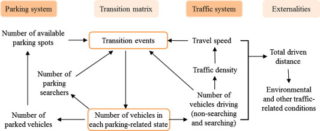
System dynamics of urban traffic based on its parking-related-states
In: Transportation Research part B: Methodological. Mehr PDF The urban parking and traffic systems are essential components of the overall urban transportation structure. The interactions between them can be highly influential to their performance. Here, we propose a methodology to model macroscopically such interactions and evaluate their effects on Continua
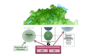
Gesamtwirtschaftliche Effekte des öffentlichen Verkehrs mit besonderer Berücksichtigung der Verdichtungs- und Agglomerationseffekte
Schlussbericht an SBB Lab, St. Gallen. Bern und Zürich: IVT, ETH Zürich und Ecoplan. Mehr Mit dieser Studie wurden zum ersten Mal für die Schweiz die Agglomerationseffekte (wider economic benefits) quantifiziert und räumlich analysiert. Eine Verbesserung der ÖV-Erreichbarkeit um 100 Prozent führt zu einer Produktivitätssteigerung von durchschnittlich 1 bis Continua
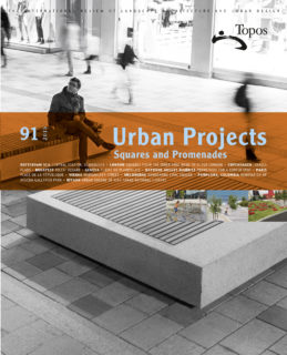
The Renaissance of Nakta Mountain
Topos, 91. Callwey, Munich. Mehr The article illustrates recent design trends in South Korea`s landscape architecture. As the country’s prosperity slowly increased after the Korean War, South Korea began to develop a design vocabulary based on its own traditions and culture. Using the example of Naksan Park, the Continua
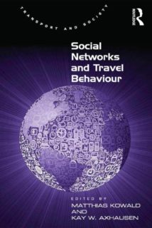
Social Networks and Travel Behaviour
Ashgate, Surray (UK). Mehr Leisure travel is increasing in importance and is more complex and variable than work-related travel. Providing an overview of selected exemplary studies, this volume addresses the overlap between transport planning and methods of social network analysis; applied methods of social network analysis and related Continua
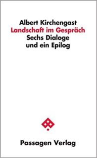
Landschaft im Gespräch. Sechs Dialoge und ein Epilog
Wien: Passagen Verlag. Mehr Fünf Dialoge mit Persönlichkeiten aus Architektur (Gion A. Caminada), Literatur (Andreas Maier, Martin Pollack) und Philosophie (Axel Honneth, Lothar Schäfer) nähern sich der «Landschaft» und legen Elemente eines ästhetischen Landschaftsverständnisses frei. Eine Bildstrecke des Fotografen Christian Vogt und ein Epilog des Naturästhetikers Jörg Zimmermann Continua
Evaluation of trade-offs between two data sources for the accurate estimation of OD matrices
In: Transportmetrica B: Transport Dynamics. DOI 10.1080/21680566.2015.1025892 Mehr The paper evaluates the trade-offs between loop detector data and floating car data for the real-time estimation of origin–destination matrices in small networks. Results are used to evaluate the trade-offs between loop detector coverage and the penetration rate of floating car Continua
Global Schindler Award 2015 Shenzhen Essays Projects
Schindler Group and ETH Zürich. Mehr As a companion to the Global Schindler Award 2015 that was curated by the Chair of Prof. Kees Christiaanse, the essays and projects in this book present possible strategies and design approaches to the challenge of rapid urbanization and the related spatial, Continua
Young-Old: Urban Utopias of an Aging Society.
Zürich: Lars Müller Publishers. More Young-Old examines contemporary architectural and urban mutations that have emerged as a consequence of one of the key demographic transformations of our time: aging populations. Distinguishing between different phases of old age, the book identifies the group known as the «young old» Continua
From absolute protection to controlled disaster: New perspectives on flood management in times of climate change
In: Journal of Landscape Architecture, 10 (1). S.16–25. More How we conceive of flood disaster and the means to protect ourselves have evolved radically through centuries. Following centuries of deluge angst and blinding technicism, current adaptation projects bring about a new perspective that reintegrates flooding into spatial perception Continua
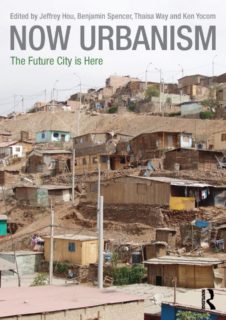
Forget About Utopia
In: Hou, Jeffrey; Spencer, Benjamin; Way, Thaisa; Yocom, Ken (Hrsg.): Now Urbanism: The Future City Is Here. Routledge. More This book explores the intersections of critical inquiry and immediate, substantive actions. The contributions recognize the rich complexities of the present city not as barriers or obstacles but as grounds for uncovering opportunity Continua
![]()
Integrated Transport and Land Use Modeling for Sustainable Cities
Lausanne: EPFL Press, distributed by Routledge. More Sustainable development is a goal of planners and politicians and ever more prominent for urban areas where development agglomerates. The SustainCity consortium further developed the methodology and tools for integrated modelling and analysis of land use transport systems. The IVT implemented Continua
![]()
How international borders affect local public transport: Analyses and evaluations of cross-border agglomerations in Switzerland. France and Germany
Dissertation, IVT-Schriftenreihe Nr. 167 PDF This dissertation report examines the various effects that international borders exert on local public transport systems in high density agglomerations with regard to demand, passenger expectations and framework conditions. Furthermore, it identifies related challenges and derives approaches and recommendations from the analysis.
![]()
Shape Grammars Overview and Assessment for Transport and Urban Design – Review, Terminology, Assessment, and Application
In: Journal of Transport and Land Use. Mehr Transport and urban planners increasingly deploy shape grammars especially in simulations and procedural models. The paper sheds light on the terminology and bridges the gap to the natural language context. An approach is suggested for standardized shape grammars definitions and Continua
Partial proportional odds model: An alternate choice for analyzing pedestrian crash injury severities
In: Accident Analysis & Prevention, 72. S.330–340. Mehr This study is based on a five-year national pedestrian safety dataset for Switzerland. It explores the application of a partial proportional odds (PPO) model to bridge the gap between conventional crash injury severity models. The study shows that PPO models Continua
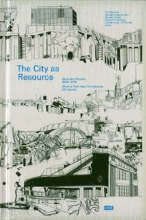
The City as Resource
Texts and Projects 2005–2014, Chair of Prof. Kees Christiaanse, ETH Zurich. Jovis, Berlin. Mehr The city itself is a resource, as it opens up a wide range of possibilities for every individual and for society as a whole. The city is not an inexhaustible resource, however. Only if Continua
![]()
Effects of non-aeronautical activities at airports on the public transport access system: A case study of Zurich Airport
In: Journal of Air Transport Management (online 9 September 2014) ISSN 0969-6997. Mehr Non-aeronautical activities at airports generate travellers that have different characteristics than air passengers or airport employees. The study investigated at the case of Zurich airport if this leads to increased public transport ridership, mode share, Continua
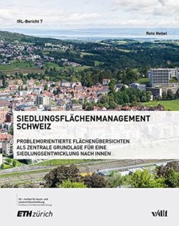
Siedlungsflächenmanagement Schweiz. Problemorientierte Flächenübersichten als zentrale Grundlage für eine Siedlungsentwicklung nach innen
Publikationen des Instituts für Raum- und Landschaftsentwicklung (IRL) der ETH Zürich, Band 7. vdf Hochschulverlag. Mehr Der haushälterische Umgang mit dem Boden kann nur durch ein wirkungsvolles Siedlungsflächenmanagement umgesetzt werden. Was darunter zu verstehen ist und wie die Operationalisierung erfolgen kann, wird in diesem Buch nachgegangen. Basierend auf Ergebnissen Continua
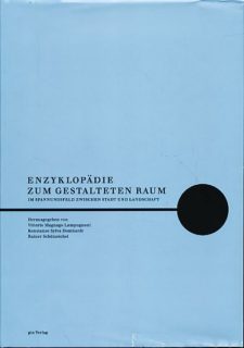
Enzyklopädie zum gestalteten Raum. Im Spannungsfeld zwischen Stadt und Landschaft
Zürich. Mehr Ausgehend von einer ganzheitlichen, synoptischen Sicht untersucht die Publikation die Mechanismen der Gestaltung des eng verwobenen Kulturraums von Stadt und Landschaft. Aus einer entschieden historischen Perspektive und einem die Planungs-, Geistes- und Kulturwissenschaften verbindenden Blickwinkel werden annähernd 40 Elemente unserer physischen Umwelt exemplarisch analysiert.
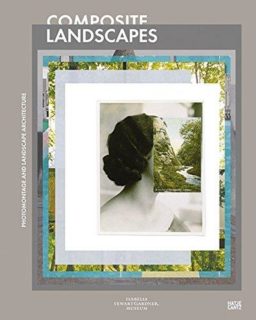
Back to Form. Landscape Architecture and Representation in Europe after the Sixties
In: Waldheim, Charles; Hansen, Andrea (Hrsg.): Composite Landscapes. Photomontage and Landscape Architecture. Ostfildern: Hatje Cantz. S.92–115. Mehr Composite Landscapes examines one of landscape architecture’s most recognizable representational forms, the montage view. The volume gathers work from a select group of influential contemporary artists and a dozen of the world’s Continua