NSL – Netzwerk Stadt und Landschaft ETH Zürich
  • Projets
      • Projets des chaires
          • Prof. Dr. Bryan T. Adey | Gestion des infrastructures
          • Prof. Dr. Tom Avermaete | Histoire et théorie de l’urbanisme
          • Prof. Dr. Kay W. Axhausen | Planification des transports
          • Prof. Dr. Francesco Corman | Systèmes de transport
          • Prof. Teresa Galí-Izard | Chair of Being Alive
          • Prof. Dr. Adrienne Grêt-Regamey | Aménagement du paysage et des systèmes urbains
          • Prof. Dr. Eva Heinen | Planification des transports et de la mobilité
          • Prof. Dr. David Kaufmann | Aménagement du territoire et politique urbaine
          • Prof. Hubert Klumpner | Architecture et urbanisme
          • Dr. Anastasios Kouvelas | Ingénierie de trafic et surveillance
          • Prof. Dr. Christian Schmid | Sociologie
          • Prof. Milica Topalovic | Architecture et aménagement du territoire
          • Dr. Jennifer Duyne Barenstein | ETH Wohnforum – ETH CASE
          • NSL-Archiv
      • Anciennes chaires
      • Colloques NSL – Le colloque NSL consiste en une présentation semestrielle d’un travail remarquable. Le thème est à chaque fois défini par la chaire qui invite.
      • Projets NSL
          • E-Bike City
          • Future Cities Lab Global
          • Stratégies et potentiels urbains dans des territoires métropolitains d’après l’exemple de l’espace métropolitain de Zurich (PNR 65)
          • Large-scale Virtualization and Modeling Lab (LVML)
      • NSL Forum
        • NSL Forum & Cycling Research Board
        • NSL Forum: Pandemie? Mitten im Klimawandel. Was bedeutet das für die räumliche Entwicklung der Schweiz? Ein Dialog.
    Close
  • Enseignement
    • Enseignement
        • Bachelor et mastère, departement ARCH
        • Bachelor et mastère département BAUG
        • MSc en Développement territorial et Systèmes d’infrastructures
        • MAS/CAS in Regenerative Materials
        • CAS ETH en Regenerative Systems: de la durabilité à la régénération
        • MAS/CAS Aménagement du territoire
        • MAS Urban and Territorial Design
        • MAS ETH en logement
        • Doctoral Programme in Landscape and Urban Studies
      • La connaissance des forces déterminantes pour les développements territoriaux et de leurs concomitances, mais aussi l'aptitude au développement de stratégies de solutions pour les problématiques territoriales, sont des conditions centrales pour l'exercice responsable et efficace des missions de conception au service de collectivités publiques ou d'entreprises privées. Tout aussi décisifs sont les formations universitaires initiale et continue, et le perfectionnement dans les disciplines d'aménagements territorial, urbain et paysager. L'ETH Zurich propose dans ces disciplines depuis 1965 des cours de formation continue et des cycles d'études post-diplôme (NDS, aujourd'hui MAS). Ils sont organisés par le Réseau Ville et Paysage (NSL).
    Close
  • Publications
    • Cover NL 65Newsletter – Le NSL rassemble des experts de l’ETH Zurich et entretient un dialogue avec d’autres milieux qui traitent ou s’intéressent à des questions liées à la ville et au paysage.
    • A map describing the different phases of India’s neoliberal highway programme. Source: The author.Publications des chaires du NSL – La liste complète des publications avec option de recherche avancée peut être atteinte via le lien suivant:
      • ETH Zürich Research Collection
    • disP – The Planning Review – La revue scientifique interdisciplinaire traite de thèmes tirés des domaines suivants: aménagement du territoire, aménagement urbain/urbanisme, aménagement du paysage et de l’environnement, architecture du paysage, économie régionale et de l’environnement, mais aussi planification des transports.
      • Instructions pour les auteur·trice·s
      • Types of Articles
      • Editeur
      • Directives pour les comptes-rendus de livres
      • Rédaction
      • Version actuelle
      • facebook
    • DELUS Cover Issue 1DELUS – Revue sur les études urbaines et paysagères – DELUS est une revue annuelle de l’Institut d’études urbaines et paysagères de l’ETH Zurich.
    Close
  • Actualités
  • Contact
      • fr
        • de
        • en
        • it
      • Search

    • Close
      • fr
        • de
        • en
        • it

Quantifying long-term evolution of intra-urban spatial interactions

Cities, as the core of modern society, are playing increasingly important roles through global urbanisation, providing people with housing, transportation, communication, and functional institutions for various social activities. Enabled by the transportation infrastructure layer, diverse social interactions among various entities shape a city’s interaction layers, creating social economic outputs, which further spur the growth of the cities themselves.

However, understanding the long-term impact that changes in a city’s transportation infrastructure have on its spatial interactions remains a challenge, as the real impact may not be revealed in static or aggregated mobility measures such as traffic flow, which are remarkably robust to perturbations. More generally, the lack of longitudinal and cross-sectional data demonstrating the evolution of spatial interactions at a meaningful urban scale further hinders evaluation of the sensitivity of movement indicators, limiting our capacity to understand the evolution of urban mobility in depth.

Lijun Sun and team from the Future Cities Laboratory of the Singapore-ETH Centre investigated ways to detect the change of urban structure using emerging big data. Using large-scale individual-based transit data over three years, the team quantified the impact of the completion of a metro line extension – the Circle Line (CCL) in Singapore on the urban structural evolution of Singapore.

In the paper Quantifying Long-term Evolution of Intra-urban Spatial Interactions published in the Journal of The Royal Society Interface, the team reported that, despite Singapore being known to be a dynamic and fast-changing city, human mobility displays robust statistical patterns invariance before and after the public transit infrastructure was completed.

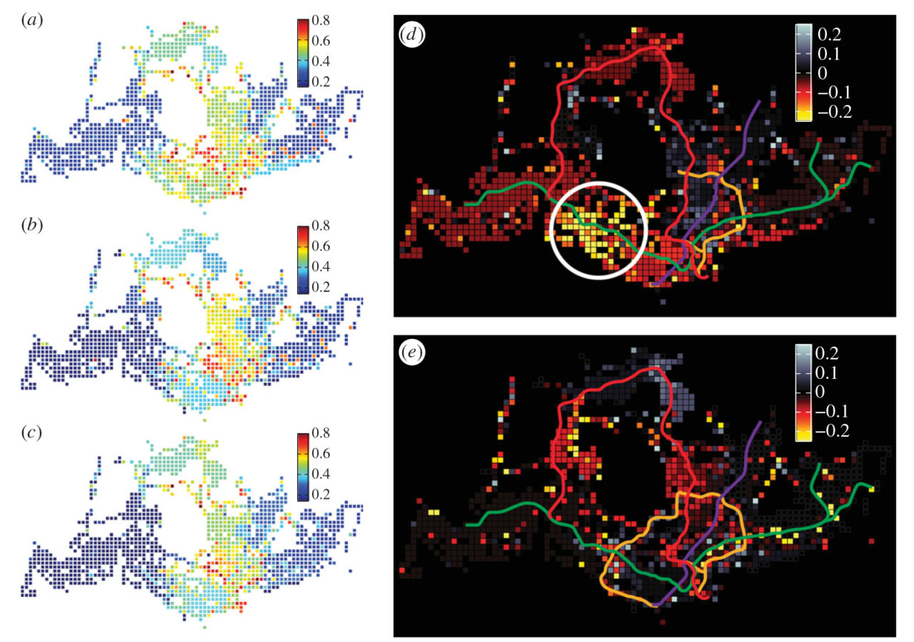
However, the team identified community mutability, which can only be measured via highly disaggregated mobility traces, as a highly sensitive measure that is able to uncover the subtle yet global effects of the infrastructure project in the evolution of spatial interactions. The team found that mutability is a highly sensitive index to detect the change in human mobility caused by major transportation infrastructure, showing the evolving borders in urban community structure and with this the way people interact to shape, sustain or transform a city.

The completion of the CCL enables travellers to re-identify their desired destinations collectively with lower transport cost, making the community structure more consistent. These changes in locality are dynamic and characterised over short time scales, offering a different approach to identify and analyse the long-term impact of new infrastructures on cities and their evolution dynamics.

The team believes that the findings and analysis framework offers analytical tools to better sense the evolution of mobility patterns in cities, providing insights for urban planning, modeling and understanding the evolution of cities through the coupling of infrastructure and interaction networks.

Lijun Sun is a researcher from the Mobility and Transportation Planning module of the Future Cities Laboratory of the Singapore-ETH Centre. His main focus lies on data-driven transport modeling, public transport, human mobility, and behaviour and cities and citizens.

Image: The figure shows spatial distribution of overall mutability index over three years: (A) 2011 (B) 2012 and (C) 2013. Panel (D) and (E) show the difference from 2011 to 2012 and from 2012 to 2013, respectively.

Share this...
  • Facebook
  • Linkedin
  • Whatsapp
  • Email
Cet article a été publié dans le newsletter suivant:

24 | Dezember 2014: Energie(wende)

  • Sharing is Saving: How collaborative mobility can reduce the impact of energy consumption for transportation
  • Die Rolle der Raumplanung bei der Transformation der elektrischen Energieversorgung
  • Visuell-akustische Simulationen zur umfassenderen Standortevaluation von Windparks
  • Strategies for energy efficiency of rail freight transportation
  • Electric Vehicle Simulation
  • Quantifying long-term evolution of intra-urban spatial interactions
Kurzmeldung
  • 3D GIS zur Planung von elektrischen Versorgungsnetzen
  • Elektrifizierung des nicht-spurgeführten städtischen öffentlichen Verkehrs – Ein betrieblicher Systemvergleich
  • Zernez Energia 2020 gewinnt Sonderpreis
  • Der Raum im Städtebau 1890–1930: Positionen in Theorie und Praxis
  • Die Systematisierung städtebaulichen Wissens: Eine wissenschaftsgeschichtliche Untersuchung städtebaulicher Manuale in der Gründungsphase der Disziplin Städtebau (1875-1930)
  • Urbane Profile
  • The Public Spectacle
Publikationen
  • Landschaft als Wunderkammer. Fragen nach einer Haltung. / Landscape as a Cabinet of Curiosities. In Search of a Position
  • Back to Form. Landscape Architecture and Representation in Europe after the Sixties
  • Enzyklopädie zum gestalteten Raum. Im Spannungsfeld zwischen Stadt und Landschaft
  • Siedlungsflächenmanagement Schweiz. Problemorientierte Flächenübersichten als zentrale Grundlage für eine Siedlungsentwicklung nach innen
  • Effects of non-aeronautical activities at airports on the public transport access system: A case study of Zurich Airport
  • The City as Resource
  • Partial proportional odds model: An alternate choice for analyzing pedestrian crash injury severities
  • Shape Grammars Overview and Assessment for Transport and Urban Design – Review, Terminology, Assessment, and Application

Chaires

Prof. Dr. Bryan T. Adey
Prof. Dr. Kay W. Axhausen
Prof. Dr. Tom Avermaete
Prof. Maria Conen
Prof. Dr. Francesco Corman
Dr. Jennifer Duyne Barenstein
Prof. Teresa Galí-Izard
Prof. Dr. Adrienne Grêt-Regamey
Prof. Dr. Guillaume Habert
Prof. Dr. Eva Heinen
Prof. Damian Jerjen
Prof. Dr. David Kaufmann
Prof. Hubert Klumpner
Dr. Anastasios Kouvelas
Prof. Freek Persyn
Prof. Dr. Christian Schmid
Prof. Milica Topalovic
Prof. Martina Voser

Contact

Adresse
ETH Zürich
NSL – Netzwerk Stadt und Landschaft
Stefano-Franscini-Platz 5
HIL H 44.2
8093 Zürich

Direction NSL
Directeur: Prof. Dr. David Kaufmann
Représentante du directeur: Prof. Milica Topalovic

Bureau de coordination NSL
Claudia Gebert
Téléphone: +41 (0)44 633 36 33


Inscrivez-vous à la newsletter NSL

Rédaction disP

Rédactrice responsable
Dr. sc. techn. Martina Koll-Schretzenmayr, aménageuse territoriale ETH/NDS,
Téléphone +41 (0)44 633 29 47

Adresse
ETH Zürich
Redaktion disP
NSL – Netzwerk Stadt und Landschaft
Stefano-Franscini-Platz 5
HIL H 33.3
8093 Zürich
Fax +41 (0)44 633 12 15
Adresse électronique

Archive NSL (gta)

Archives de recherche et posthumes pour l’architecture du paysage et l’aménagement du territoire suisses.

Recherche

Adresse
ETH Zürich
NSL Archive (gta)
Stefano-Franscini-Platz 5
HIL C 65.2
CH-8093 Zurich


Protection des données