NSL – Netzwerk Stadt und Landschaft ETH Zürich
  • Projets
      • Projets des chaires
          • Prof. Dr. Bryan T. Adey | Gestion des infrastructures
          • Prof. Dr. Tom Avermaete | Histoire et théorie de l’urbanisme
          • Prof. Dr. Kay W. Axhausen | Planification des transports
          • Prof. Dr. Francesco Corman | Systèmes de transport
          • Prof. Teresa Galí-Izard | Chair of Being Alive
          • Prof. Dr. Adrienne Grêt-Regamey | Aménagement du paysage et des systèmes urbains
          • Prof. Dr. Eva Heinen | Planification des transports et de la mobilité
          • Prof. Dr. David Kaufmann | Aménagement du territoire et politique urbaine
          • Prof. Hubert Klumpner | Architecture et urbanisme
          • Dr. Anastasios Kouvelas | Ingénierie de trafic et surveillance
          • Prof. Dr. Christian Schmid | Sociologie
          • Prof. Milica Topalovic | Architecture et aménagement du territoire
          • Dr. Jennifer Duyne Barenstein | ETH Wohnforum – ETH CASE
          • NSL-Archiv
      • Anciennes chaires
      • Colloques NSL – Le colloque NSL consiste en une présentation semestrielle d’un travail remarquable. Le thème est à chaque fois défini par la chaire qui invite.
      • Projets NSL
          • E-Bike City
          • Future Cities Lab Global
          • Stratégies et potentiels urbains dans des territoires métropolitains d’après l’exemple de l’espace métropolitain de Zurich (PNR 65)
          • Large-scale Virtualization and Modeling Lab (LVML)
      • NSL Forum
        • NSL Forum & Cycling Research Board
        • NSL Forum: Pandemie? Mitten im Klimawandel. Was bedeutet das für die räumliche Entwicklung der Schweiz? Ein Dialog.
    Close
  • Enseignement
    • Enseignement
        • Bachelor et mastère, departement ARCH
        • Bachelor et mastère département BAUG
        • MSc en Développement territorial et Systèmes d’infrastructures
        • MAS/CAS in Regenerative Materials
        • CAS ETH en Regenerative Systems: de la durabilité à la régénération
        • MAS/CAS Aménagement du territoire
        • MAS Urban and Territorial Design
        • MAS ETH en logement
        • Doctoral Programme in Landscape and Urban Studies
      • La connaissance des forces déterminantes pour les développements territoriaux et de leurs concomitances, mais aussi l'aptitude au développement de stratégies de solutions pour les problématiques territoriales, sont des conditions centrales pour l'exercice responsable et efficace des missions de conception au service de collectivités publiques ou d'entreprises privées. Tout aussi décisifs sont les formations universitaires initiale et continue, et le perfectionnement dans les disciplines d'aménagements territorial, urbain et paysager. L'ETH Zurich propose dans ces disciplines depuis 1965 des cours de formation continue et des cycles d'études post-diplôme (NDS, aujourd'hui MAS). Ils sont organisés par le Réseau Ville et Paysage (NSL).
    Close
  • Publications
    • Cover NL 65Newsletter – Le NSL rassemble des experts de l’ETH Zurich et entretient un dialogue avec d’autres milieux qui traitent ou s’intéressent à des questions liées à la ville et au paysage.
    • A map describing the different phases of India’s neoliberal highway programme. Source: The author.Publications des chaires du NSL – La liste complète des publications avec option de recherche avancée peut être atteinte via le lien suivant:
      • ETH Zürich Research Collection
    • disP – The Planning Review – La revue scientifique interdisciplinaire traite de thèmes tirés des domaines suivants: aménagement du territoire, aménagement urbain/urbanisme, aménagement du paysage et de l’environnement, architecture du paysage, économie régionale et de l’environnement, mais aussi planification des transports.
      • Instructions pour les auteur·trice·s
      • Types of Articles
      • Editeur
      • Directives pour les comptes-rendus de livres
      • Rédaction
      • Version actuelle
      • facebook
    • DELUS Cover Issue 1DELUS – Revue sur les études urbaines et paysagères – DELUS est une revue annuelle de l’Institut d’études urbaines et paysagères de l’ETH Zurich.
    Close
  • Actualités
  • Contact
      • fr
        • de
        • en
        • it
      • Search

    • Close
      • fr
        • de
        • en
        • it

When the Dog is Dead, Throw it in the River – Mapping and the Challenges of the Ciliwung

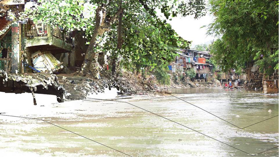
Urban rivers facing pressure from rapid urbanisation often take on multiple roles beyond their natural ecological function. The Ciliwung River flows through the megacity of Jakarta and is located in West Java, Indonesia. Along with many rivers in Southeast Asia it has become an environmental buffer to Jakarta’s poorly managed waste. A popular Javanese jingle from the 1990’s includes the phrase: «…when the dog is dead, throw it in the river», and serves to illustrate some of the complex cultural factors behind the long-compromised role of Indonesia’s rivers.

The Future Cities Laboratory’s (FCL) Landscape Ecology team has been researching the Ciliwung River since 2011. The cumulative research efforts within this challenging context often required the use of unconventional methods to obtain what is generally considered base knowledge. A variety of simulations and design scenarios have been produced as a result of the work.

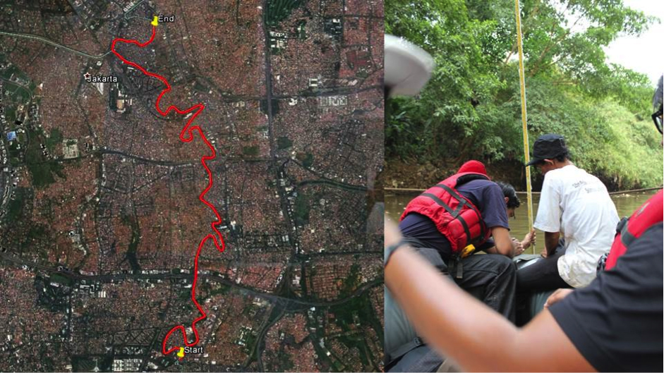
In October 2013 four members of the FCL’s Landscape Ecology team travelled the Ciliwung River by boat. The objective of the journey was to ground-truth bathymetric information along the river against official measurements which were provided by local ministries. This field checking was essential to constructing a digital model of the river, and required documenting its physical attributes including the depth and width of key cross-sections using spatially referenced measurements.

A series of collaborations with community groups were essential to the success of the expedition, as they provided necessary local knowledge and were more resilient to unexpected events that befell the team. For example, a garbage blockage meant that the boat itself needed to be lifted out of the river and carried some 50-meters overland before the expedition could continue. Meanwhile, an initial attempt to measure the depths of the river was thwarted by the strength of the current, which destroyed some equipment and meant that the measurement tools also had to adapt.

This anecdotal attempt to map the Ciliwung River provided a foundational understanding and context to the physical attributes of the site. The information sourced during the mapping exercise has since been valuable in the material investigation of specific site elements. Thus these new methods of mapping, a result of the collaboration between locals and researchers, have been  essential in furthering the team’s work on the Ciliwung River.

Results

The work was presented in a conference and exhibition in Jakarta, in November 2014, and was recently exhibited at Singapore’s Urban Redevelopment Authority in ‘Future Cities: Research in Action’, from January to March 2015. It is also scheduled to be included in the Shenzhen Biennale at the end of the year. The research of the Landscape Ecology team will be compiled in a series of journal articles and published as a Special Issue in the journal of Sustainable Cities and Society titled ‘Rehabilitating urban rivers: merging science with design’. 

Expedition Team

Ervine Lin, Yazid Ninsalam, Michaela F. Prescott, Federica Remondi, Kashif Shaad 

Principal Investigators, Research Module Landscape Ecology 

Prof. Christophe Girot (PI), Prof. Dr. Paolo Burlando (Co PI), Prof. Dr. Adrienne Grêt-Regamey (Co PI), Associate Prof. Dr. Jörg Rekittke (NUS) and Prof. Dr. Liong Shie Yui (NUS) 

Researchers

Dr. Senthil Gurusamy, Dr. Rita Padawangi, Diogo Costa, Ervine Lin, Yazid Ninsalam, Michaela F. Prescott, Federica Remondi, Kashif Shaad, Derek Vollmer 

Community Group

Relawan Peduli Ciliwung   
NL25: When the Dog is Dead, Throw it in the River – Mapping and the Challenges of the Ciliwung
Map illustrating the 12-kilometers travelled along the Ciliwung River from Condet to Kampung Melayu (left side). A researcher and a member of a community group working together to take a depth measurement (right side). Source: Federica Remondi
Share this...
  • Facebook
  • Linkedin
  • Whatsapp
  • Email
Cet article a été publié dans le newsletter suivant:

25 | März 2015: Mapping

  • Mapping Everything
  • «Explorative Data-Mapping – Experimental Teaching Tools» innerhalb des MAS in Landscape Architecture
  • Verkehrsinfrastruktur, Macht, Staat
  • Geographies of Opportunity
  • When the Dog is Dead, Throw it in the River – Mapping and the Challenges of the Ciliwung
Kurzmeldungen
  • Workshops zur Kartierung von Ökosystemleistungen
  • Improving Pedestrian Mobility Through Bottom-Up Strategies, ETH-EiABC Workshop 2014 Addis Ababa Ethiopia
  • NSM – Advancing the Model for Safety Improvement of the Road Network in the City of Zurich
  • Effiziente Flughafenerschliessungssysteme im Hinblick auf die Landnutzung an Flughäfen
  • Neue Studienleitung des MAS, CAS, DAS Raumplanung
  • Teilnehmende für Eye-Tracking-Studie gesucht
Publikationen
  • How international borders affect local public transport: Analyses and evaluations of cross-border agglomerations in Switzerland. France and Germany
  • Integrated Transport and Land Use Modeling for Sustainable Cities
  • Forget About Utopia
  • Analysis of the Network Exit Functions for different urban grid network configurations
  • From absolute protection to controlled disaster: New perspectives on flood management in times of climate change
  • Young-Old: Urban Utopias of an Aging Society.

Chaires

Prof. Dr. Bryan T. Adey
Prof. Dr. Kay W. Axhausen
Prof. Dr. Tom Avermaete
Prof. Maria Conen
Prof. Dr. Francesco Corman
Dr. Jennifer Duyne Barenstein
Prof. Teresa Galí-Izard
Prof. Dr. Adrienne Grêt-Regamey
Prof. Dr. Guillaume Habert
Prof. Dr. Eva Heinen
Prof. Damian Jerjen
Prof. Dr. David Kaufmann
Prof. Hubert Klumpner
Dr. Anastasios Kouvelas
Prof. Freek Persyn
Prof. Dr. Christian Schmid
Prof. Milica Topalovic
Prof. Martina Voser

Contact

Adresse
ETH Zürich
NSL – Netzwerk Stadt und Landschaft
Stefano-Franscini-Platz 5
HIL H 44.2
8093 Zürich

Direction NSL
Directeur: Prof. Dr. David Kaufmann
Représentante du directeur: Prof. Milica Topalovic

Bureau de coordination NSL
Claudia Gebert
Téléphone: +41 (0)44 633 36 33


Inscrivez-vous à la newsletter NSL

Rédaction disP

Rédactrice responsable
Dr. sc. techn. Martina Koll-Schretzenmayr, aménageuse territoriale ETH/NDS,
Téléphone +41 (0)44 633 29 47

Adresse
ETH Zürich
Redaktion disP
NSL – Netzwerk Stadt und Landschaft
Stefano-Franscini-Platz 5
HIL H 33.3
8093 Zürich
Fax +41 (0)44 633 12 15
Adresse électronique

Archive NSL (gta)

Archives de recherche et posthumes pour l’architecture du paysage et l’aménagement du territoire suisses.

Recherche

Adresse
ETH Zürich
NSL Archive (gta)
Stefano-Franscini-Platz 5
HIL C 65.2
CH-8093 Zurich


Protection des données