NSL – Netzwerk Stadt und Landschaft ETH Zürich
  • Projekte
      • Projekte der Professuren
        • Prof. Dr. Bryan T. Adey | Infrastrukturmanagement
        • Prof. Dr. Tom Avermaete | Geschichte und Theorie des Städtebaus
        • Prof. Dr. Kay W. Axhausen | Verkehrsplanung
        • Prof. Dr. Francesco Corman | Verkehrssysteme
        • Prof. Dr. Adrienne Grêt-Regamey | Planung von Landschaft und Urbanen Systemen
        • Prof. Dr. David Kaufmann | Raumentwicklung und Stadtpolitik
        • Prof. Hubert Klumpner | Architektur und Städtebau
        • Dr. Anastasios Kouvelas | Strassenverkehrstechnik
        • Prof. Dr. Christian Schmid | Soziologie
        • Prof. Milica Topalovic | Architektur und Territorialplanung
        • EiR PD Dr. Joris Van Wezemael | Spatial Transformation Laboratories (STL)
        • Prof. em Dr. h. c. Günther Vogt | Landschaftsarchitektur
        • ETH Wohnforum – ETH CASE
        • NSL-Archiv
      • NSL Kolloquienreihe – Präsentation herausragender Arbeit zu einem von der einladenden Professur festgelegten Thema.
      • NSL Projekte
        • Future Cities Lab Global
        • Urbane Potentiale und Strategien in metropolitanen Territorien
 – am Beispiel des Metropolitanraums Zürich (NFP65)
        • Landscape Visualization and Modeling Lab (LVML)
      • NSL Forum: Pandemie? Mitten im Klimawandel. Was bedeutet das für die räumliche Entwicklung der Schweiz? Ein Dialog.
      • Ehemalige Lehrstühle
    Close
  • Lehre
    • Lehrangebote
      • Bachelor- und Masterstudium Departement ARCH
      • Bachelor- und Masterstudium Departement BAUG
      • MSc Raumentwicklung und Infrastruktursysteme
      • MAS/CAS Raumentwicklung
      • MAS Urban and Territorial Design
      • MAS in Housing
      • Doctoral Programme in Landscape and Urban Studies
      • Die Kenntnis der für die räumlichen Entwicklungen massgebenden Kräfte und deren Zusammenwirken wie auch die Fähigkeit zur Entwicklung von Lösungsstrategien für räumliche Problemstellungen sind zentrale Voraussetzungen für verantwortungsvolles und erfolgreiches Ausüben planerischer Funktionen im Dienste öffentlicher Gemeinwesen und privater Unternehmen. Entsprechend bedeutend ist die universitäre Aus-, Weiter- und Fortbildung im Bereich der Raum-, Stadt- und Landschaftsplanung. An der ETH Zürich werden in diesem Bereich seit 1965 Fortbildungs-Kurse und Nachdiplom-Studiengänge (NDS, heute MAS) angeboten. Träger ist das NSL (Netzwerk Stadt und Landschaft).
    Close
  • Publikationen
    • Newsletter – Das NSL führt Fachleute der ETH Zürich zusammen und pflegt den Dialog mit weiteren Kreisen, die sich mit Fragen rund um Stadt und Landschaft befassen oder sich dafür interessieren.
    • Ausgewählte Publikationen der NSL–Professuren – Eine vollständige Publikationsliste mit erweiterten Suchfunktionen ist über den folgenden Link zu erreichen:
      • ETH Zürich Research Collection
    • DISP_58/3_CoverdisP – The Planning Review – Die interdisziplinäre wissenschaftliche Zeitschrift behandelt Themen aus den Bereichen Raumentwicklung, Stadtplanung/Städtebau, Landschafts- und Umweltplanung, Landschaftsarchitektur, Regional- und Umweltökonomie sowie Verkehrsplanung.
      • In disP – The Planning Review publizieren
      • Verlag
      • Richtlinien für Buchbesprechungen
      • Redaktion
      • Aktuelle Ausgabe
    Close
  • Aktuell
  • Kontakt
      • de
        • en
        • fr
        • it
      • Search

    • Close

44 | Dezember 2019: Methoden / Methods

Sehr geehrte Leserinnen und Leser

Die am NSL erforschten Methoden sind so divers wie deren Anwendungsgebiete: «Urban Commons» für neue urbane Sozialräume, «Backcasting» für partizipative Planungsprozesse, «real options» für schwer vorhersehbare städtische Infrastruktur-Anpassungen, das Gehen oder Spazieren für eine Gebietsanalyse, «Equasim» für agentenbasierte Modellierungen, «Punktwolken-Modellierungen» für die Umgestaltung von Landschaften und «virtuelle Realität» für die Planung von Radwegen…

Wir wünschen viel informatives Lesevergnügen!

Paolo Mendes da Rocha, MMBB Arquitetos. Sesc 24 de Maio, 2000-2017 © Claudia Kim

Collective Actors and the Production of the City: Urban Commons in Research

Irina Davidovici, Nicole la Hausse de Lalouviere | chair of Tom Avermaete, History and Theory of Urban Design

In her book Governing the Commons (1990), political economist and Nobel prize winner Elinor Ostrom identified spaces and infrastructures as ‘common resources’ fostered by groups of citizens in order to resist top-down governance and commodification. Today, the notion of the ‘urban commons’ appears as an index for historians to look more closely at a number of collective actors and operations that have gone beyond the dominant agencies of the state and the market to develop new types of urban spaces. Our research examines the collective actors behind urban initiatives and spatial resources conceived as a ‘common good’.

Mehr

Zukunftsbild Wauwiler Ebene. Erarbeitet in der Landwirtschaftlichen Planung (LP+), 2019 © PLUS, ETH Zürich. | Zitate: «Die Produktion von Lebensmitteln stellt den Hauptbestandteil der landwirtschaftlichen Tätigkeit dar. Die Bewirtschafter sind stolz darauf, standortangepasst zu produzieren und vielfältige Produkte anzubieten.» | «Landwirtschaftliche Bauten können im erforderlichen Umfang realisiert werden. Es findet laufend eine Koordination mit der Archäologie, der Naherholung und anderen Nutzungen statt. Eine hohe Siedlungsqualität ist auf der 2019 bestehenden Siedlungsfläche erreicht.» | «Ein vielfältiges, vernetztes Lebensraummosaik mit Feuchtgebieten ist ein Fundament der ‹Landschaftsperle Wauwiler Ebene› und der hohen Biodiversität in der Wauwiler Ebene.» | «Für Familien ist der Ausflug in die Wauwiler Ebene ein Erlebnis. Dafür bilden die Leistungen der Landwirtschaft das Fundament und die Bevölkerung schätzt diese Leistungen.» | «Die Bewirtschafter profitieren vom Wissen früherer Generationen. Dies – kombiniert mit aktuellem Know-how – ist eine Stärke der Wauwiler Ebene. So ist die Wauwiler Ebene ein Vorbild beim Umgang mit der Ressource Wasser sowie bei der Koordination der Themen Wegenetz und Freizeitnutzung.»

Backcasting – vom Übermorgen zum Heute: Modellgestützte Landschaftsplanung

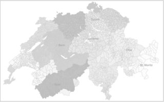
Sven-Erik Rabe, Enrico Celio | Professur Adrienne Grêt-Regamey, Planung von Landschaft und Urbanen Systemen (PLUS)

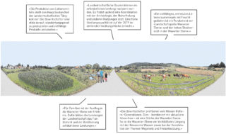
Partizipative Planungsprozesse leben von einer gemeinsamen Vision der Beteiligten. Sie hilft, den Prozess und die Diskussionen konstruktiv zu gestalten. Es bleibt jedoch offen, welche Schritte und Massnahmen zur Erreichung der Vision erforderlich sind. Am Fall Wauwiler Ebene wurden diese Fragen mit der Methode des Backcastings beantwortet und Handlungsschwerpunkte definiert.

Mehr

Figure 1 – The future in the past 1: Flying cars in Los Angeles 2019, from the film Blade Runner (1982). Source: https://www.vox.com/culture/2017/10/2/16375126/blade-runner-future-city-ridley-scott

Future-proofed Urban Areas: Real Options in Urban Planning

Dr. Claudio Martani | chair of Bryan T. Adey, Infrastructure Management

The societal needs for infrastructure change drastically over time depending on a large variety of factors, which are very difficult to predict. It is in the face of this massive uncertainty, that urban planners are expected to make infrastructure decisions. To minimize the service risks over time, the real options method is used to develop future-proofed urban areas.

Mehr

Zürich Walkabout: Roaming through the Unbuilt (photo: Nazlı Tümerdem)

Walking in the Territory

Dr. Nazlı Tümerdem | chair of Milica Topalović, Architecture and Territorial Planning

Can we, as researchers of the territory, still investigate and learn about our built and the unbuilt environments through direct experience? Can we rely merely on digital cartographies, or should we still be explorers who embark on journeys of discovery? We have tried to answer these questions by walking in the city in order to discover what is hidden, and by travelling the world of literature in order to arrive at critical insights.

Mehr

Visualisation of eqasim generated MATsim agents in action in the centre of Paris/Zurich. © Sebastian Hörl (Matsim 2019)

Eqasim: An Open-source and Extensible Platform for Building Agent-based Models

Sebastian Hörl, Miloš Balać | chair of Kay W. Axhausen, Transport Planning and Systems (IVT)

Agent-based models in transportation model individual travelers and their interaction in the transport system on a micro-level. A natural advantage of agent-based models are flexibility and the ability to model emergent behavior. Work at IVT has produced a new software package, eqasim, that drastically simplifies the design of scenarios for agent based models using open data.

Mehr

The Rail Corridor in Singapore was scanned to produce a point cloud model of the site, shown here in sections colored by height. The model is disassembled in entities and is transformed to include landscape designs, shown in white, with exact geo-location and with site-specific characteristics. © Philipp RW Urech, FCL, ETH Zurich

Designing with the Form of the Landscape

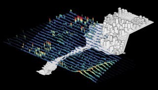
Philipp RW Urech | Future Cities Lab (FCL) | chair of Christophe Girot, Landscape Architecture

A new approach in landscape design uses point cloud modeling to integrate spatial, aesthetic and quantitative features of the landscape. The method is applicable in any location and thus makes it useful to a wide range of topics, whether in the context of cultural, agricultural or urban landscapes, with design challenges about rising water levels, flooding, forest fires, noise and air pollution, and urban heat island.

Mehr

Cycling in Virtual Reality for Improved Bike Paths

Using Virtual Reality to Evaluate Cyclist’s Perceived Safety

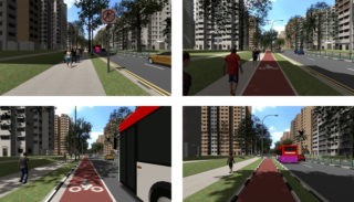
Michael van Eggermond, Mohsen Nazemi | Future Cities Lab (FCL) | chair of Kay W. Axhausen, Transport Planning and Systems (IVT)

Researchers at the Future Cities Laboratory are using virtual reality (VR) in cycling experiments to reveal users’ cycling behaviour and preferences in different environments. These insights can help planners understand and quantify the impact of infrastructure improvements in setting guidelines and prioritization of new infrastructure.

Mehr

Kurzmeldungen

Poster Master ETH in Landscape Architecture

New Master of Science ETH in Landscape Architecture

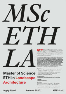
We offer a new two-year master’s programme in landscape architecture at the department of architecture of ETH Zurich with a focus on the design and planning of open spaces and landscapes. This master’s programme in landscape architecture, initiated by Prof. Teresa Galí-Izard, Prof. Christophe Girot and Prof. Günther Vogt, is the first and only such programme in Switzerland.
Mehr

Teresa Galí-Izard

Neue Professorin für Landschaftsarchitektur am LUS

Prof. Teresa Galí-Izard (*1968), zurzeit ausserordentliche Professorin an der Harvard Graduate School, Cambridge, USA, wurde zur ordentlichen Professorin für Landschaftsarchitektur am Institut für Landschaft und Urbane Studien (LUS, NSL) berufen.

Mehr

Tagung Landmanagement – Rück- und Ausblick

Der lebendige ländliche Raum ist eines der grossen Themen der Raumentwicklung. Hier treffen Tradition und wirtschaftliche Innovation, neue Rechtsgrundlagen und Emotionen aufeinander. Die 13. Landmanagement Tagung «Herausforderungen der baulichen Entwicklung im ländlichen Raum» bot den aktuellen und vielfältigen Themen aus Verwaltung, Forschung und Praxis eine Plattform.
Auch der Schwerpunkt der 14. Tagung Landmanagement ist bereits bekannt: am 10. November 2020 steht die Erschliessung und Vernetzung der multifunktionalen Landschaft im Fokus. Sven-Erik Rabe; Planung von Landschaft und Urbanen Systemen (PLUS)

Der Stadtschreiber

Marc Angélil hat die Architekturlehre an der ETH entscheidend mitgeprägt, sowohl als Professor wie auch als Vorsteher des Departements. Seit Jahren forscht er zu politischen, sozialen und ökonomischen Treibern der globalen Verstädterung. Im Rahmen seiner Emeritierung wirft er nochmals einen kritischen Blick auf aktuelle Urbanisierungstrends.

Gespräch mit Prof. Dr. Marc Angélil im ETH Life.

Publikationen

Dies ist eine Auswahl. Eine vollständige Liste finden Sie in der ETH Zürich Research Collection.

Buchcover Mutation und Morphose / Mutation and Morphosis, Professur Günther Vogt
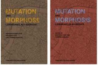
Günther Vogt, Thomas Kissling

Mutation und Morphose. Landschaft als Aggregat

Wer aus der Distanz betrachtet, was wir «Landschaft» nennen, wird erkennen, dass es sich dabei um ein Artefakt handelt, um einen Lebensraum, von Menschen geschaffen als Teil der gebauten Stadt. Die Gestaltung dieses Raums ist eine Disziplin von zunehmender Bedeutung. Günther Vogt hat sich mit VOGT Landschaftsarchitekten und der Professur an der ETH Zürich ein Instrumentarium geschaffen und eine Arbeitsweise entwickelt, welche von der grossmassstäblichen Landschaft bis zum kleingliedrigen öffentlichen Stadtraum alle Dimensionen der gestalteten Umwelt einbeziehen.

Mehr

Khiali-​Miab, Amin, van Strien, Maarten J., Axhausen, Kay W. & Adrienne Grêt-​Regamey (2019). Combining urban scaling and polycentricity to explain socio-​economic status of urban regions. PLoS ONE, 14 (6), e0218022
Amin Khiali-Miab, Maarten J. van Strien, Kay W. Axhausen, Adrienne Grêt-Regamey

Combining Urban Scaling and Polycentricity to Explain Socio-economic Status of Urban Regions

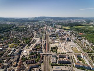
The fast pace of urbanisation may benefit or be detrimental to the socio-economic status of urban areas. Understanding how the configuration of urban areas influences the socio-economic status of their inhabitants is of crucial importance for urban planning.

Mehr

Understanding Traffic Capacity of Urban Networks: Figure 1. Traffic in urban road networks. (a) Shows the layers of urban transportation networks. The city with all streets forms the basis, where a major road network takes over the connecting functions and then the public transport system. Background map is courtesy of OpenStreetMap. (b) Time series of a single detector on a street in Zurich, and (c) the corresponding scatter plot of detector occupancy versus flow. When aggregating al measurements in the purple area in (a), smooth curves in the flow-density domain (d), and in the speed density domain (e) emerge.
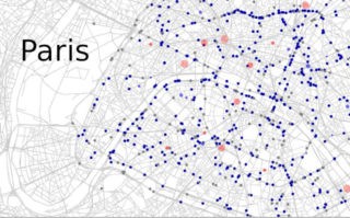
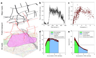
Allister Loder, Lukas Ambühl, Monica Menendez, Kay W. Axhausen

Understanding Traffic Capacity of Urban Networks

Traffic in an urban network becomes congested once there is a critical number of vehicles in the network. To improve traffic operations, develop new congestion mitigation strategies, and reduce negative traffic externalities, understanding the basic laws governing the network’s critical number of vehicles and the network’s traffic capacity is necessary.

Mehr

Stellenausschreibungen

Aktuell

Dies ist eine Auswahl. Alle Artikel finden Sie auf der Seite Aktuell.

Transformation der Stadtlandschaft in Schlieren © Timon Furrer

Urbane Transformationen

Prof. David Kaufmann, Dr. Markus Nollert, PD Joris Van Wezemael | Raum- und Landschaftsenwicklung

Politik und Planung | Raum und Technologie | Design und Raumplanung

Mehr

Biennale Public Space

Call for Papers: Public Space – the Real and the Ideal

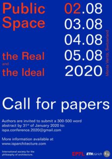
Call for papers by 6th January 2020.

The aim of the conference is to stress ideas and ideals on public space, both in architecture, landscape architecture, urban design, as well as in (political) philosophy, against the background of the continuous development of technology, from smart phone to smart city.

5th Biennial Conference of the International Society of the Philosophy of Architecture, to be held August 2nd to August 5th 2020, Monte Verità (near Locarno), Switzerland. Co-organized by the ETH Zurich, chair of Prof. Tom Avermaete, and EPFL, Laboratorium Van Gerrewey.

Redaktionsteam

Isabelle Fehlmann, Institut für Landschaft und Urbane Studien (LUS), Landschaftsarchitektur
Melanie Fessel, Institut für Landschaft und Urbane Studien (LUS), Städtebau
Claudia Gebert, Koordinationsstelle NSL, Chefredaktion
Metaxia Markaki, Institut für Landschaft und Urbane Studien (LUS), Städtebau
Joe Molloy, Institut für Verkehrsplanung und Transportsysteme (IVT)
Bettina Weibel, Institut für Raum- und Landschaftsentwicklung (IRL)

  • 56 | Dezember 2022: Trans-disziplinarität
  • 55 | September 2022: Ort / Place
  • 54 | Juni 2022: Artificial Intelligence / Machine Learning
  • 53 | März 2022: Agency
  • 52 | Dezember 2021: Risiko / Risk
  • 51 | September 2021: Umwelt im Wandel / Transitional Environments
  • 50 | Juni 2021: Nothilfe / Emergency Aid
  • 49 | März 2021: Future Cities Lab Global
  • 48 | Dezember 2020: Communication | Mediation
  • 47 | September 2020: Umgang mit Krisen / Adaption to Crisis
  • 46 | Juni 2020: Partizipation II / Participation II
  • 45 | May 2020: Partizipation I / Participation I
  • 44 | Dezember 2019: Methoden / Methods
  • 43 | September 2019: Verdichtung / Density
  • 42 | Juni 2019: Politik und Raum / Politics and Space
  • 41 | April 2019: Urbane Qualität / Urban Quality
  • 40 | Dezember 2018: Technologie beeinflusst Verhalten / Technology Influences Behaviour
  • 39 | Oktober 2018: Öffentlicher Raum / Public Space
  • 38 | Juni 2018: Big Data in der Forschung / Big Data in Research
  • 37 | März 2018: Arbeiten im internationalen Umfeld / International Context Work
  • 36 | Dezember 2017: Geräuschkulissen
  • 35 | September 2017: Ressourcen
  • 34 | Juni 2017: Ein Blick in die Zukunft
  • 33 | März 2017: Ein Blick zurück
  • 32 | Dezember 2016: Infrastrukturen
  • 31 | September 2016: Bezahlbar wohnen
  • 30 | Juni 2016: Vogelperspektive
  • 29 | März 2016: Unter der Oberfläche
  • 28 | Dezember 2015: Stadt und Nahrung
  • 27 | September 2015: Abschlussbericht Future Cities Laboratory FCL
  • 26 | Mai 2015: Nationalfondsprojekt 65, Neue Urbane Qualität: Abschlussberichte
  • 25 | März 2015: Mapping
  • 24 | Dezember 2014: Energie(wende)
  • 23 | September 2014: Resilienz
  • 22 | Juni 2014: Aktivitäten des NSL-Mittelbaus
  • 21 | März 2014: Informelle Siedlungen
  • 20 | Dezember 2013: Visualisierungen
  • 19 | September 2013: Bahn und Raumentwicklung
  • 18 | Juni 2013: Verdichtung
  • 17 | März 2013: Weiterbildung am NSL
  • 16 | Dezember 2012: Nationalfondsprojekt 65: Neue Urbane Qualität
  • 15 | September 2012: Inter- und Transdisziplinarität
  • 14 | Juni 2012: Wissenstransfer
  • 13 | März 2012: Projekte des Future Cities Laboratory in Singapur
  • 12 | Dezember 2011: Wasser / Landschaft
  • 11 | September 2011: Infrastrukturen
  • 10 | Juni 2011: Risiko
  • 09 | März 2011: Analyse unseres Verhaltens in den Städten
  • 08 | Dez. 2010: Alpenraum und Nord-Süd Transversale
  • 07 | Sept. 2010: Daten sammeln, archivieren, zur Verfügung stellen
  • 06 | Juni 2010: Mobilität
  • 05 | März 2010: Bilder und Videos
  • 04 | Dez. 2009: Gesellschaft / Soziologie
  • 03 | Sept. 2009: Nachhaltigkeit
  • 02 | Juni 2009: Städtebau
  • 01 | März 2009: Weiterbildung am NSL

Professuren

Prof. Dr. Bryan T. Adey
Prof. Dr. Kay W. Axhausen
Prof. Dr. Tom Avermaete
Prof. Maria Conen
Prof. Dr. Francesco Corman
Dr. Jennifer Duyne Barenstein
Prof. Teresa Galí-Izard
Prof. Dr. Adrienne Grêt-Regamey
Prof. Dr. Guillaume Habert
Prof. Dr. David Kaufmann
Prof. Hubert Klumpner
Dr. Anastasios Kouvelas
Prof. Freek Persyn
Prof. Dr. Christian Schmid
Prof. Milica Topalovic
EiR PD Dr. Joris Van Wezemael
Prof. em Dr. h.c. Günther Vogt
ETH Wohnforum – ETH CASE

Kontakt

Adresse
ETH Zürich
NSL – Netzwerk Stadt und Landschaft
Stefano-Franscini-Platz 5
HIL H 44.2
8093 Zürich

Leitung NSL
Leiter: Prof. Hubert Klumpner
Stv. Leiter: Prof. Dr. David Kaufmann

Koordinationsstelle NSL
Claudia Gebert
Telefon: +41 (0)44 633 36 33

Für den NSL Newsletter anmelden

Redaktion disP

Leitende Redaktorin
Dr. sc. techn. Martina Koll-Schretzenmayr, Raumplanerin ETH/NDS,
Telefon +41 (0)44 633 29 47

Redaktionsassistenz
Telefon +41 (0)44 633 29 69

Adresse
ETH Zürich
Redaktion disP
NSL – Netzwerk Stadt und Landschaft
Stefano-Franscini-Platz 5
HIL H 33.2
8093 Zürich
Fax +41 (0)44 633 12 15
E-Mail


NSL Archiv (gta)

Forschungs- und Nachlassarchiv für
Schweizer Landschaftsarchitektur und Raumplanung

Nutzungsanfragen

Adresse
ETH Zürich
NSL Archive (gta)
Stefano-Franscini-Platz 5
HIL C 65.2
CH-8093 Zurich